Enable true ground-informed design in Civil 3D Sponsored

Our understanding of ground conditions evolves with the project, so geotechnical design teams need a reliable way to work with the latest information.
Instead of relying on static imports, teams can refresh models and profiles with a click, helping reduce manual rework and improve confidence in every design decision.
The extension also brings rich geotechnical information including lithology, lab results, and groundwater data directly into Civil 3D, making it easier to understand site conditions and manage risk.
Why a true database connection changes everything
Still relying on basic connectors and static data? Manual geotechnical workflows are time-consuming, error-prone, and quickly outdated when interpretations change and new investigations are added.
When you compare a standard, disconnected workflow to a true database connection, the differences in efficiency, risk management, and data governance become obvious:
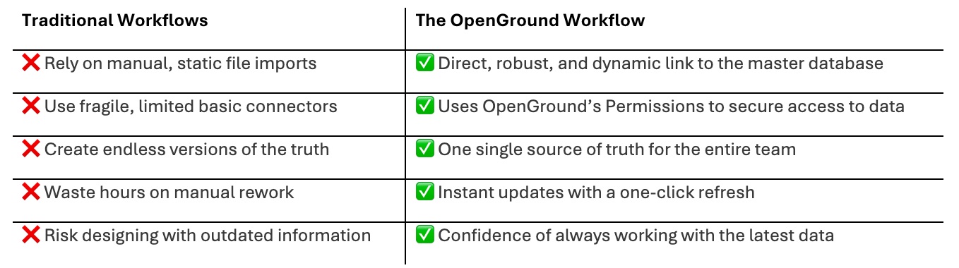
OpenGround provides a direct, dynamic connection that sets it apart from other solutions. For civil teams, this means access to current, trusted data for more confident design decisions.
For ground engineering leads, it means retaining complete control over the master database while safely sharing validated insights – no more throwing data over the wall.
Going beyond basic pins to stream rich data
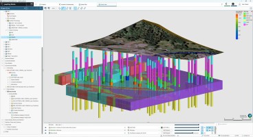
Basic tools only give you pin data. A true integration allows you to connect directly to your OpenGround cloud project and stream comprehensive geotechnical data – including lithology, lab results, and more – directly into your Civil 3D environment.
This deep visibility helps teams assess ground conditions more effectively and manage risk with greater confidence.
High-quality workflows depend on being able to visualise detailed lithology and full log strips directly in Civil 3D, so teams can understand the full geotechnical context before finalising design decisions.
Related content:- OpenGround | Cloud geotechnical data management – Seequent
- A powerful data hub for Schnabel engineering with OpenGround
- SeequentGeotechnical Data Governance Health Check Tool
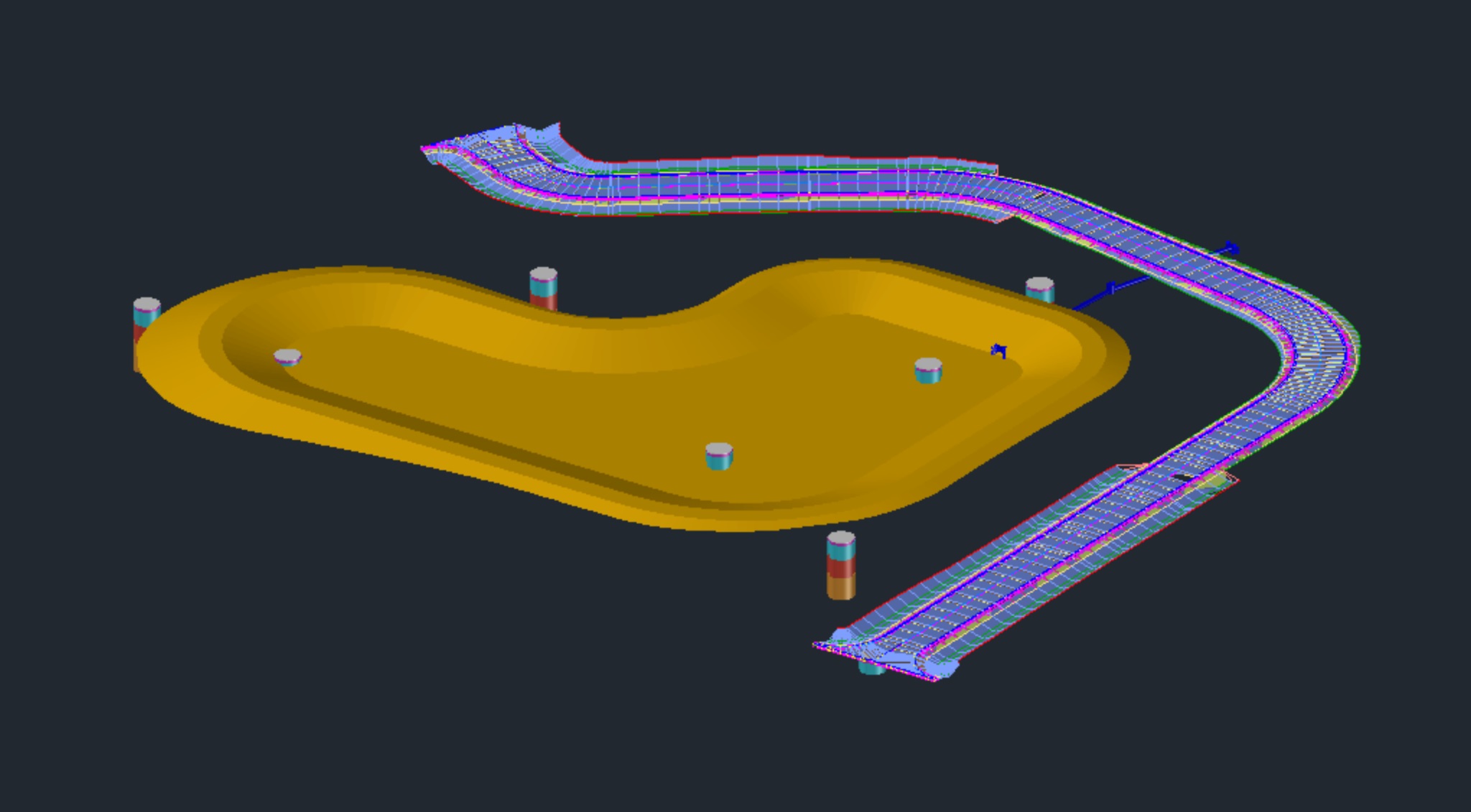
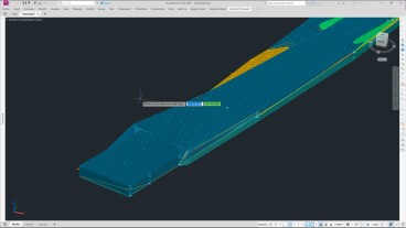
Create detailed profiles directly from interpretations
Bring database interpretations directly into Civil 3D to generate and update detailed geological profiles for complex ground conditions. This connected workflow reduces hours of manual drafting and produces clear, accurate cross-sections of your site.
When ground conditions change, a simple one-click refresh instantly syncs your profiles and models with any updates in the OpenGround database whenever you choose.
Discover what true integration looks like
See how a direct connection to your geotechnical database goes beyond basic connectors, file-based workflows, and limited API integrations.
Watch our technical session to discover how the OpenGround Civil 3D Extension helps teams work with connected, up-to-date geotechnical data and design with greater confidence.
- Move beyond static imports and work with a dynamic geotechnical model that you synchronise whenever you choose.
- Leverage rich data to de-risk your projects and design with confidence.
- Automatically draw comprehensive geotechnical profiles from your interpretations, saving hundreds of design hours.
Want to read more like this story?
Enable True Ground-Informed Design in Civil 3D with OpenGround
Jun, 12, 2026 | EventJoin us to discover how the OpenGround extension for Autodesk Civil 3D enables true ground-informed...

Bentley’s OpenGround Cloud Platform: Increase the Value of your Geotechnical Data
Jul, 21, 2020 | NewsOpenGround Cloud, Bentley's secure enterprise cloud collaboration platform for geotechnical data ma...

Bentley System announces availability of OpenGround Cloud: The secure, cloud-based collaboration platform for geotechnical data management
Sep, 17, 2020 | NewsBentley Systems, Incorporated, has announced the availability of OpenGround Cloud, a new cloud serv...

Leapfrog Works
Dec, 29, 2022 | Software
Life after gINT - Rethinking geotechnical data management for a new era
Mar, 26, 2026 | NewsA turning point for the industry gINT has long been the backbone of geotechnical data management....
Geotechnical modeler replacement: making the subsurface part of your Civil 3D design with GeoDin Ground
Jun, 30, 2026 | NewsIf you design infrastructure in Autodesk Civil 3D and you have outgrown manual borehole imports, the...

Bridging the gap between geotechnical and civil design: From OpenGround to OpenRoads
Apr, 09, 2025 | EventUnderstanding the subsurface is critical to improving infrastructure design. Join us for an insight...

Going digital: US Army Corps of Engineers turns $500k into $500m data asset
Mar, 05, 2025 | NewsDataforensics unlocked incredible value for the US Army Corps of Engineers by moving subsurface dat...

ACCELERATE: Going Digital with OpenGround
May, 26, 2020 | EventRegister for free to Bentley's upcoming webinar to learn more about OpenGround, a collection of geo...
Form
Looking for more information? Fill in the form and we will contact Seequent, The Bentley Subsurface Company for you.
On This Day
July 22nd 1869
READ MORE
Related Video

Trending

Seequent announced extended gINT support until Dec 31, 2028
New Release: GeoStudio 2025.2

Artificial Ground Freezing: Applications, Techniques, and Key Considerations
Brownfield success: Engineering excellence starts below ground
Asbestos remains a deadly infrastructure risk across the UK

Major earthquake in southern Philippines causes deaths and widespread damage