Levee Digital Twin Platform Launches for California's Yuba River Corridor
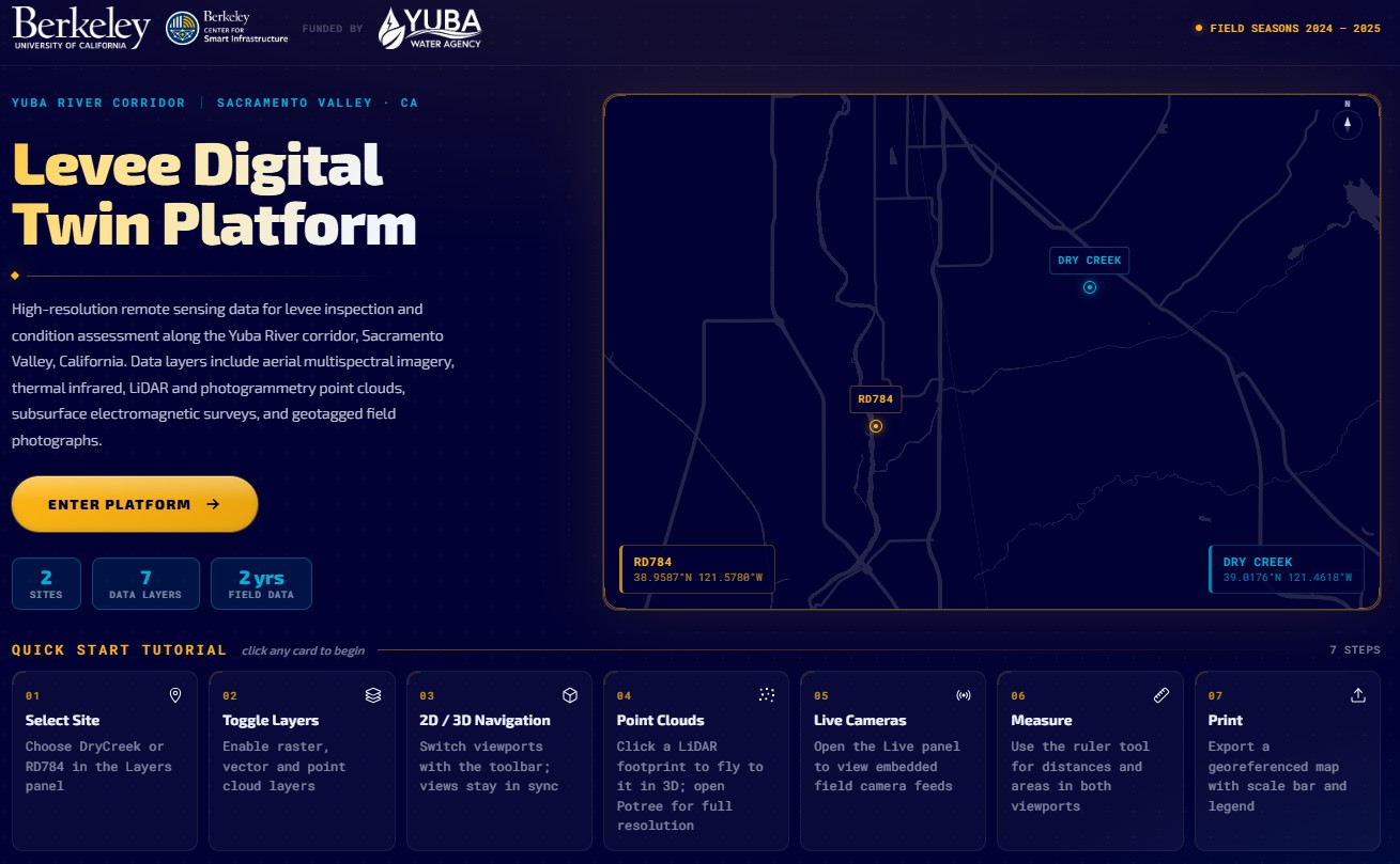
Researchers at UC Berkeley, funded by Yuba Water, have unveiled the Levee Digital Twin Platform — a comprehensive, interactive monitoring system built for levee inspection and condition assessment along the Yuba River Corridor in Sacramento Valley, California. The platform, accessible at leveedigitaltwin.org, was developed using the EZ Digital Twins service platform, which provided the geospatial data integration, visualization, and sharing infrastructure that made the project possible.
The initiative represents a significant step forward in how engineers and asset managers approach the monitoring of flood defense infrastructure. Rather than relying on periodic visual inspections and manual data collection, the Levee Digital Twin Platform unifies multiple high-resolution data streams into a single, continuously updated digital representation of the levee system.
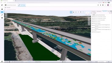
The platform integrates multiple distinct data layers collected across two field seasons between 2024 and 2025, covering two sites — RD784 and Dry Creek — along the Yuba River Corridor. Data layers include aerial multispectral imagery, thermal infrared, LiDAR and photogrammetry point clouds, subsurface electromagnetic surveys, boreholes and piezometer reading, embedded cameras and geotagged field photographs. Users can toggle between 2D and 3D viewports, fly to point cloud models, run measurements, watch cameras and sensors readings and export mapping layouts — all from within a browser-based interface.

Levees are among the most consequential and underleveraged assets in public infrastructure. The levee systems of California's Sacramento Valley protect hundreds of thousands of residents and billions of dollars in agricultural and urban property, yet monitoring has historically lagged behind other critical infrastructure categories. Digital twin technology — combining real-time sensor data, remote sensing, and predictive analytics — offers a path toward earlier detection of seepage anomalies, settlement, and structural degradation, long before conditions become critical.
The Levee Digital Twin Platform demonstrates that this approach is not only technically viable but also practically deployable using existing managed platforms.
The platform is publicly accessible at leveedigitaltwin.org and includes a seven-step quick-start tutorial guiding users through site selection, layer toggling, 2D/3D navigation, point cloud interaction, live camera/sensor feeds, measurement tools, and map export.
EZ Digital Twins as the Enabling Platform
The Levee Digital Twin Platform was built on EZ Digital Twins, a managed geospatial digital twin service designed for infrastructure professionals. EZ Digital Twins handled the integration of multi-modal data — sensors, LiDAR, imagery, and analytics — into a single, interactive environment, removing the need for the research team to build and maintain bespoke backend infrastructure.
More information on the EZ Digital Twins platform is available at ezdigitaltwins.com.
Want to read more like this story?

The Year in Infrastructure 2020: ACCELERATE - Design Integration Webinar Series
Oct, 21, 2020 | NewsJoin Bentley’s design integration leadership team as they investigate how infrastructure companies...

Bentley Systems Recognizes the Year in Infrastructure 2023 as Groundbreaking for Infrastructure Intelligence
Oct, 13, 2023 | NewsAt its annual Year in Infrastructure conference, Bentley Systems, Incorporated (Nasdaq: BSY), the i...

Digital Water Works, Inc. Receives Investment from Bentley Systems
Mar, 05, 2019 | NewsDigital Water Works, a leading global innovator of digital twin solutions for smart wet infrastruc...

Bentley Systems Announces Bentley Infrastructure Cloud, Powered by iTwin
Nov, 15, 2022 | NewsProjectWise Leads Advancement to Data-centric Digital Delivery and Digital Twin Opportunities...

The Year in Infrastructure 2020 Conference is Going Digital
Jun, 11, 2020 | NewsBentley Systems’ Year in Infrastructure Conference is Going Digital for the first time ever in 2020...

Bentley Systems Issues Call for Nominations for the 2021 Going Digital Awards in Infrastructure
Mar, 30, 2021 | NewsBentley Systems, Incorporated has announced its call for nominations for the 2021 Going Digital Awa...

Building the Future Underground: Implementation Strategies and What’s Next
Oct, 30, 2025 | NewsThe implementation of digital twins isn’t simply about adopting new software tools. It requires dev...
Bentley Systems Launches iTwin Experience, iTwin Capture, and iTwin IoT to Extend iTwin Platform
Nov, 15, 2022 | NewsiTwin to Empower Bentley Infrastructure Cloud and Advance Bentley’s Engineering Applications...

Bentley Systems Announces the Acquisition of Keynetix Software
May, 28, 2019 | NewsBentley Systems announced the acquisition of Keynetix, a UK-headquartered provider of cloud-based...
On This Day

Related Video

Trending

Dubai approves $9.2bn fully underground gold line metro
How to prevent copper wire theft from light poles
The quicksand of Morecambe Bay

Model Structures and Visualize Structural Forces
Rapid Drawdown in Dam and Levee Design: A Hydrogeologic Perspective in Slide2
Major wastewater tunnel procurement begins in southern Sweden