Artemis II Completes Lunar Geological Reconnaissance: What It Means for Geotechnical Engineering

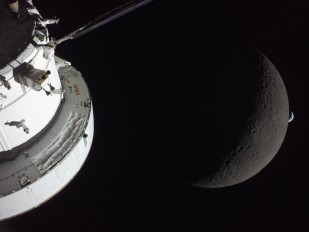
With its crew now on the return trajectory toward an April 10 splashdown, NASA's Artemis II mission has completed the geology-intensive phase of the first crewed lunar flyby in over fifty years. No boots touched the regolith. No samples were collected. Yet for the geotechnical and geological engineering communities, the ten-day mission represents a significant advance. A systematic, human-conducted geological reconnaissance from orbit that will directly shape how we plan, design, and execute surface operations on the Moon in the years ahead.
The April 6 Flyby: Orbital Geology in Practice
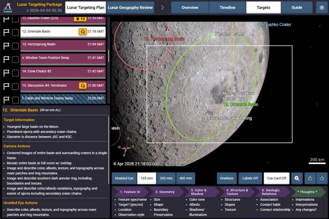
The geological centerpiece of Artemis II was the April 6 lunar flyby, during which the four-person crew carried out a structured observation campaign targeting a wide range of geological features across both the near and far sides of the Moon.
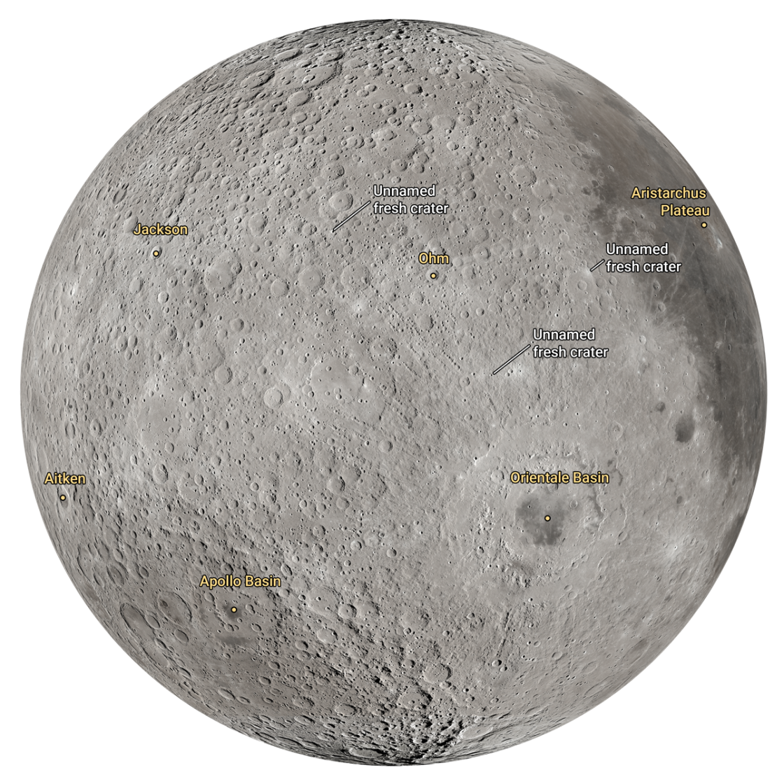
Working from a detailed lunar targeting plan developed by NASA's science team, the astronauts systematically documented impact craters, ancient lava flow structures, and large-scale geological formations. Specific observation targets included the Aristarchus Plateau, Reiner Gamma, Orientale Basin, Hertzsprung Basin, Glushko Crater, Ohm Crater, Vavilov Crater, and areas near the South Pole-Aitken and Apollo basins [10]. The observing plan was designed to enable direct comparison of near-side and far-side terrains across four key parameters: color, albedo, topography, and texture.
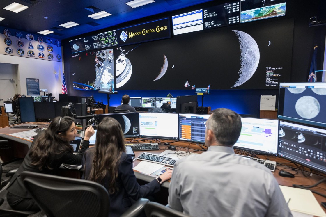
A dedicated lunar science team, with expertise spanning impact cratering, volcanism, tectonism, and lunar ice, supported the crew in real time from mission control, guiding observations and receiving geological descriptions as the flyby unfolded.
Human Observers as Geological Instruments
A defining element of the Artemis II science rationale is the premise that trained human eyes contribute geological information that remote sensing platforms cannot fully replicate. NASA's science team has emphasized that astronauts can detect subtle color and texture variations in the lunar surface, faint pinks and oranges associated with volcanic mineral deposits, three-dimensional terrain relief, and reflectivity differences across the regolith, with a sensitivity and contextual judgment that orbital cameras alone struggle to match.
During the flyby, the crew applied this training to describe differences in shape, texture, color, and brightness across the geological targets, translating visual observations into data that scientists can use to interpret the Moon's mineral composition, volcanic chronology, and crustal structure. They also monitored for transient phenomena: impact flashes from meteoroids striking the lunar surface and lofted dust along the limb, likely driven by electrostatic processes. Understanding dust behavior at and above the surface is of direct concern to geotechnical engineers, as regolith dynamics influence the design of foundations, excavation systems, surface mobility platforms, and habitat structures intended for long-duration use in the lunar environment.
Years of Terrestrial Analog Training
The geological competence deployed during the flyby was built through years of intensive field training at terrestrial sites selected as lunar analogs.
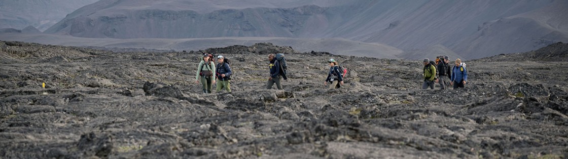
At Vatnajökull National Park in Iceland, the crew worked within barren volcanic landscapes dominated by basalt and volcanic breccia, lithologies that closely resemble the mare regions of the lunar surface. Training exercises focused on geological identification under low-angle lighting conditions that simulate the polar illumination expected at future landing sites, as well as standardized protocols for terrain description and sample selection.
A second critical site was the Kamestastin (Mistastin) Lake impact crater in Labrador, Canada, one of the few terrestrial locations where anorthosite, the dominant rock type of the lunar highlands, is accessible within an impact-modified geological context. Working at Mistastin gave the crew direct experience with the lithologies that future Artemis astronauts will encounter on the surface.
These campaigns also tested the communication and coordination frameworks required for astronauts to function as effective field proxies for planetary scientists on Earth, an operational model that was exercised in real time during the April 6 flyby.
Implications for Geotechnical Planning
From a geotechnical engineering perspective, the observational data collected during Artemis II feeds directly into the planning pipeline for Artemis III and subsequent landing missions.
Crew observations and high-resolution imagery will help refine candidate landing site selections, with particular attention to terrain stability, regolith characteristics, slope geometry, and proximity to features of scientific and resource interest, notably permanently shadowed craters where water ice may be accessible for in-situ resource utilization. NASA's science materials confirm that the human observations gathered during the flyby are intended to inform assessments of lunar composition, volcanic history, regolith properties, surface hazards, and future landing-site suitability
The regolith observations are especially relevant to the geotechnical community. Data on surface texture, reflectivity, and dust behavior under varying illumination and electrostatic conditions contribute to engineering models for trafficability, excavation mechanics, and foundation design, all critical knowledge gaps that must be addressed before permanent infrastructure can be established on the lunar surface.
A Reconnaissance Foundation
NASA is clear that Artemis II is not a sample-return or surface geology mission; actual rock collection, drilling, and ground-level investigation will begin with Artemis III and continue through subsequent campaigns. But by placing trained geological observers in lunar orbit, validating the human-integrated science model, and generating targeted observational data across dozens of geological features, Artemis II has established the reconnaissance baseline upon which all future lunar geotechnical work will build.
For an engineering discipline preparing to design, construct, and operate on another planetary body, the value of that baseline, gathered through human eyes at close range, interpreted in real time, and fed directly into surface mission planning, should not be underestimated.
Sources: NASA Johnson Space Center, "Preparing for Artemis II: Training for a Mission Around the Moon.", Canadian Space Agency, "Scientific Research During the Artemis II Mission.", NASA, "Artemis II Science.", NASA Technical Reports Server, "Artemis II Science to the Big Picture.", Scientific American, "NASA's Artemis II Moon Mission Is Gearing Up for Its Lunar Flyby.", Canadian Space Agency, "Artemis II Crew Refines Lunar Geology Skills in Iceland.", Space.com, "What Do Scientists Hope to Learn from NASA's Historic Artemis 2 Moon Flyby.", GMA Network, "How the Artemis II Crew Trained to Observe and Photograph the Moon: A NASA Science Team Geologist Explains.", NASA, "Artemis II Flight Day 6: Lunar Flyby Updates.", NASA Science, "Artemis II Lunar Targeting Plan.", NASA, "Artemis II Mission Overview."
Want to read more like this story?

Starpath’s lunar regolith Rover enters NASA’s 20-foot vacuum chamber for tests
Sep, 30, 2025 | NewsOne year after earning second place in NASA’s Break the Ice Lunar Challenge, Starpath tested its up...

USGS releases the first meticulous geological map of the Moon
Apr, 20, 2020 | NewsThe United States Geologic Survey (USGS), in collaboration with NASA and the Lunar Planetary Instit...

India to become the 4th country to land on the moon
Sep, 06, 2019 | NewsThree countries, U.S., Soviet Union and China, have managed to land a spacecraft on the moon's surf...
A circular pit on Google Maps becomes a major geology discovery
Jul, 14, 2026 | NewsA circular feature first noticed on Google Maps has led scientists to identify a previously unrecogn...

Huge meteor crater discovered in Greenland
Nov, 23, 2018 | NewsGeologists have discovered a massive crater beneath the ice sheet of Greenland. The crater was fo...
Karl Terzaghi's Legacy in Geotechnical Engineering
Jan, 15, 2013 | EducationThis article was published in the October 2002, GEO-STRATA magazine of the ASCE and was writen b...

Study reveals evidence of massive floods in a Martian crater
Nov, 05, 2020 | NewsAccording to a new study, a crater on Mars has experienced extensive floods around 4 billion years...

Material Reuse through geoBIM at HS2 Phase 1 – Area North Earthworks: Winner of Bentley Systems Going Digital Awards on Geotechnical Engineering
Nov, 24, 2022 | NewsThe 90-kilometer HS2 Phase 1 rail route has approximately 25 million cubic meters of material ear...
Brownfield success: Engineering excellence starts below ground
May, 06, 2026 | NewsWhy environmental and geotechnical teams must unite data and work as one to better manage risks in b...
On This Day
July 21st 1952
READ MORE
Related Video

Trending

Life after gINT - Rethinking geotechnical data management for a new era

Is Africa gradually splitting into two sections?

Stop Guessing, Start Designing: Introducing Support Designer in Slide2

Alert level is raised in Mexico as the Popocatépetl volcano spews ash and gas
Major wastewater tunnel procurement begins in southern Sweden