Balancing Coastal Risk: Japan’s 395–430 km Tsunami Seawall with Nature-Based Measures and Localised Opposition
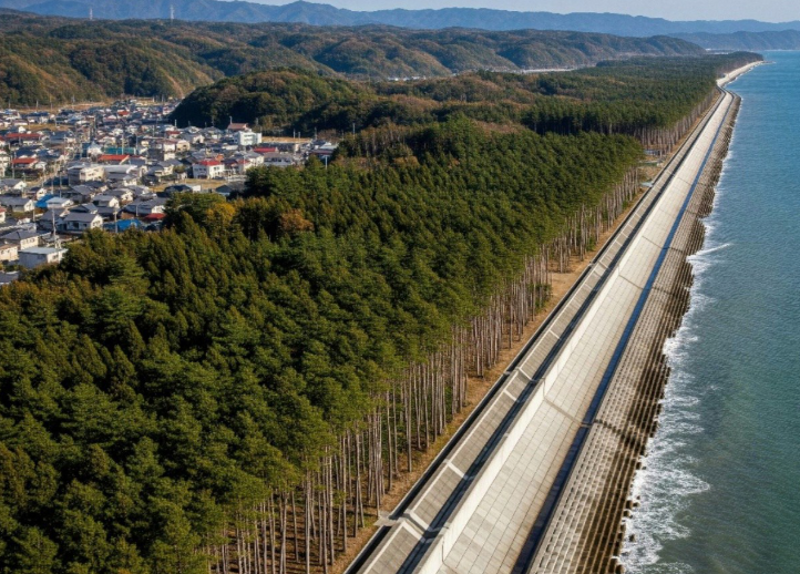
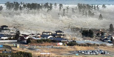
Following the 2011 Tōhoku event, authorities advanced a nationwide tsunami risk-reduction program centered on a continuous series of coastal barriers often referred to as the “Great Wall of Japan.” The program comprises approximately 395–396 km of seawalls now in service with planned extensions toward about 430 km. Typical segments rise up to 15.5 m above mean sea level and anchor into foundations reported up to 25 m deep to resist hydraulic loads and scour. A widened base provides global stability under overtopping and cyclic loading, while integrated drainage and armoring protect the backshore. The principal design objective is life safety through evacuation time gain rather than absolute wave exclusion. The wider program includes public education, early-warning systems, signed evacuation routes, and periodic drills to shorten decision time during compound events.
Recent coast-wide works combine gray defenses with large-scale ecological buffers. Approximately 9 million coastal trees form shelterbelts intended to reduce wind-blown sand loss, attenuate runup, and improve long-term shoreline stability. These living barriers aim to reduce erosion and provide co-benefits for biodiversity when paired with dunes and setback zones. In parallel, selected corridors explore nature-based solutions such as dune restoration and strategically sited parks that include berms and vegetation to diffuse wave energy. The approach recognizes that extreme events can exceed crest elevations, so layered defenses and clear egress remain critical.
Environmental Considerations and Localized Opposition
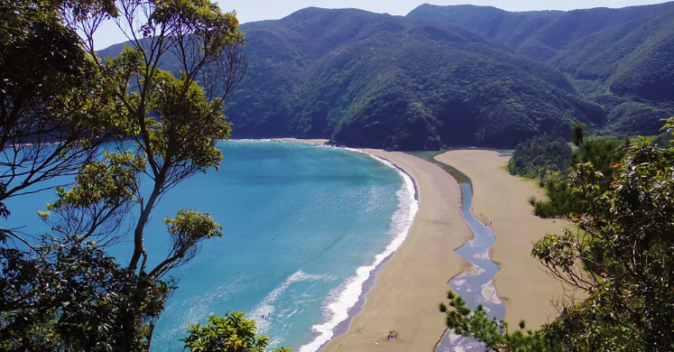
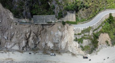
Multiple assessments note potential trade-offs. Continuous hardening can alter littoral sediment budgets, disrupt geomorphology, and reduce intertidal connectivity important to shoreline-dependent species. Communities have also raised concerns about view loss and tourism impacts where wall alignments intersect urban waterfronts. On Amami Ōshima, the planned seawall at Katoku Beach, about 180 m in length and 6.5 m in height has prompted sustained local opposition. Stakeholders cite risks to a sensitive pocket-beach system with a seasonally shifting river mouth, and to nesting habitat for protected marine turtles. Authorities state the alignment is landward of the meandering surf zone and that construction timing and monitoring plans address environmental sensitivities. The legal challenge opposing the project was dismissed, and preparatory works have advanced, yet residents and ecologists continue to advocate for alternative risk-reduction measures. Reported alternatives include reinforcing native foredunes with planting (for example, morning glories and pandanus), managing access to limit trampling, and using smaller set-back structures combined with evacuation planning. These options target wave energy dissipation while maintaining sediment exchange and habitat function.
Following a comprehensive video discussing the implications of the Japan's Great wall.

Sources: wodnesprawy.pl, .bbc.com
Want to read more like this story?
Emergency protocols activated following offshore 7.7 magnitude earthquake in Japan
Apr, 20, 2026 | NewsA powerful offshore earthquake measuring approximately 7.7 magnitude struck northern Japan on 20 Apr...
Trojena 4.7bn NEOM reservoir project stopped, leaving partial geotechnical and hydraulic challenges
Apr, 10, 2026 | NewsThe artificial lake and dam project at Trojena, part of Saudi Arabia’s NEOM development, has reporte...

Building Tunnels Responsibly: A Dual Approach to Risk
Jun, 27, 2025 | NewsAs we live in an era where tunnelling and underground technologies are rapidly gaining traction wor...

Coastal landslide destabilizes cliffside Chalets in Devon as erosion risks intensify
Mar, 27, 2026 | NewsA coastal landslide along the East Devon coastline has destabilised several beach chalets at Bransc...

Florence hurricane may cause erosion in Southeast Atlantic beaches
Sep, 21, 2018 | NewsU.S. Geological Survey (USGS) models predict that Florence Hurricane can cause beach erosion along 3...

Cardiff coastal defence scheme tackles severe erosion and complex ground conditions
Mar, 20, 2026 | NewsConstruction of the Cardiff Coastal Defence scheme at Rover Way is advancing as part of a £35.2 mil...

Sand, Storms, and Shorelines: Geotechnical Engineering Behind Jersey’s $73.5M Coastal Replenishment
Apr, 13, 2025 | NewsOcean County, New Jersey, is embracing one of its most ambitious coastal resilience projects yet—a...

Northern California Shaken: How a 7.0 Quake Tested Preparedness
Dec, 05, 2024 | NewsOn December 5, 2024, a powerful magnitude 7.0 earthquake shook Northern California, with its epicen...
Japan's Megaquake (magnitude 9.0) Warning: 300,000 Lives at Risk
Apr, 08, 2025 | NewsJapan, a seismic hotspot perched on the Pacific Ring of Fire, is bracing for a potential catastroph...
On This Day
July 18th 1635
READ MORE
Related Video

Trending

Quick Clay Failure on Norway’s E6 at Levanger

Keller North America announces recent leadership changes


Fulgurite: A rare phenomenon
Nepal’s Himalayan settlements face escalating flood and landslide threats