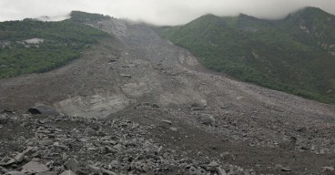
Around 1000 destructive landslides in Auckland as a result of Cyclone Gabrielle
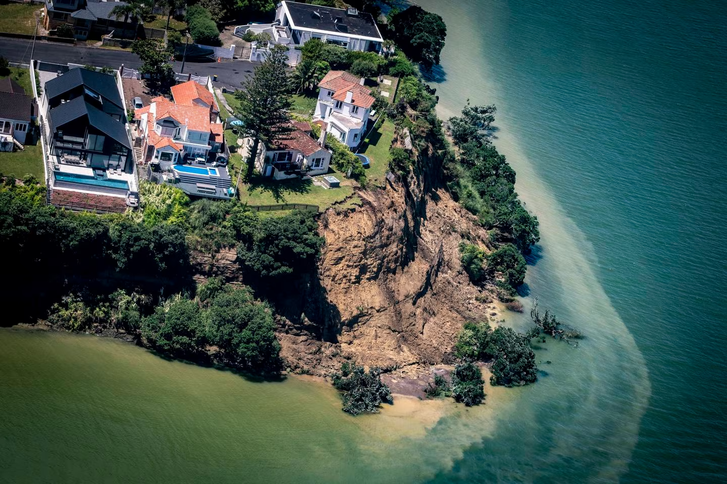
A geologist has called for a priority study of the city's vulnerability and risk, while an Auckland Council engineer estimates that recent storms have caused about 1000 landslides that have affected buildings and infrastructure. Due to landslides, access to several areas of the West Coast, such as Muriwai, Piha, Te Henga (Bethells Beach), and Karekare, remained limited. 120 teams of municipal assessors conducted quick building and welfare assessments throughout the area while due to soil instability, at least 20 home were evacuated in Piha Friday night, while a huge portion of Muriwai was under an exclusion zone.
On Monday night, during the worst of the cyclone, volunteer firefighter Dave van Zwanenberg passed away in a slide while assisting Muriwai people to flee. In one of the more tragic recent events, David Lennard of Remuera was killed on January 27 when a landslide struck his Shore Rd home, and on February 1 in Manukau Heads, several people were hurt when a beachside bach collapsed.
Ross Roberts, the head of engineering resilience for Auckland Council, estimated that the recent storms had caused between 3000 and 5000 landslides in the area, with about 1000 of those having an impact on buildings and infrastructure. Roberts also said it’d been reassuring to see that many of the landslides that had formed in Auckland’s first big storm hadn’t changed significantly in the second. “We were quite worried about that.” He recognized that Auckland didn't have a common data repository for landslide risk since it was difficult to predict the situation. But, the council was working on a work program to better understand the situation. This involved a LiDAR study of the whole coastline of the area, the first part of which is already finished.
Martin Brook, Associate Professor at the University of Auckland's School of Environment noted that the area has a history of landslides and was concerned to see some sections that appeared to be in the route of a slip that claimed the lives of two individuals in 1965. The magnitude of the Auckland region's overall landslide risk was unknown, despite Brook's suspicions that this was an issue that affected all of Auckland. “Obviously recovery is the immediate priority, but we do need to build more resilience to landslides as soon as possible – and carrying out a lot of susceptibility mapping should be part of that.”
That included building new region-wide maps based from high quality LiDAR digital elevation models, along with Interferometric Synthetic Aperture Radar (InSAR), which used satellite data to measure millimetre-level shifts in surface movement. “Ideally, this is the sort of thing that needs doing before the next wet season.” For some slopes that had already come down, Brook said the soil and rock might now be at “residual” rather than peak strength, making them more susceptible to failure in future storms. While there’d been some engineering work to suggest that residual strength of Auckland’s common Waitemata Group soils wasn’t too far below peak strength, the case was very different for the region’s weaker “quick clays”.
University of Canterbury geomorphologist Professor Tim Davies agreed the recent storms would have changed Auckland’s landslide risk profile. “The intense rain from Gabrielle, on top of the high antecedent moisture status from record rainfall the previous week, caused many failures that might otherwise not have occurred for many years,” he said. “Once ground moisture content has reverted to normal levels – which may take weeks – the risks will reduce again.” The fact many areas had slipped this week might mean more long-term weathering would be needed to “pre-condition” slopes for further failures, Davies said. “On the other hand, the slips this week might have destabilised adjacent areas and made them more likely to fail in future storms.”
Coastal hazards expert Professor Mark Dickson advised people to stay away from cliff faces until the recent storm's effects on the area's coastal cliffs had been evaluated. “Any areas where the cliff has been undermined by erosion during the cyclone will have increased risk of future landsliding.” Dickson and colleagues from the University of Auckland were trying to get satellite images that would show how much erosion there was in various eastern sections of the North Island. “Locally in Auckland, we have observed up to 5m coastal erosion at Orewa, and will be ascertaining the extent of cliff erosion at Rothesay Bay with a laser scan over the next few days. More exposed locations are likely to have eroded considerably further than the sites we have been able to observe so far”, he said.
University of Auckland river scientist Dr Jon Tunnicliffe said that the region’s rivers were again revealing the long-term impacts of land use there – namely the clearing of vegetation from terrain sensitive to big rains. “The river system is still on a trajectory of recovery from Bola; the events of early 2023 are now superimposed on this.”
After a summer of storms and easterly swell events many east coast beaches in northern New Zealand were already degraded before Gabrielle struck, Dr. Emma Ryan, a fellow coastal hazards expert said. “So far, the biggest concerns seem to be around access to beaches, loss of dune barriers and ongoing vulnerability of already compromised dune systems to future storms over the next several months.”
Source: nzherald.co.nz
Image Gallery


Media
- New Zealanders wake to full extent of cyclone devastation | ABC News
- Cyclone Gabrielle turns deadly after New Zealand devastation | 9 News Australia
Want to read more like this story?
Landslides
Oct, 31, 2019 | Education

Poorly Engineered Roads in Nepal Trigger Landslides
Aug, 05, 2016 | NewsThe 2016 monsoon season has been particularly severe in Nepal and has resulted in mass flooding and...

Urban areas at greater risk for landslides due to the effects of precipitation
Aug, 09, 2021 | NewsA new study indicates that urbanized areas are more prone to landslides caused by precipitation tha...

Torrential rain in Japan causes landslides and costs lives of 50
Aug, 27, 2014 | NewsRains, exceeding all historical records since 1976, have caused massive landslides last week in the...

Coastal landslide destabilizes cliffside Chalets in Devon as erosion risks intensify
Mar, 27, 2026 | NewsA coastal landslide along the East Devon coastline has destabilised several beach chalets at Bransc...

Landslide in Whidbey Island, Washington, takes down one house, threatens more
Mar, 27, 2013 | NewsA landslide has occurred at 4:15 am on Wednesday morning in Whidbey island. Nobody was killed, but t...
Can satellites be used as an early warning system for landslides?
Aug, 04, 2017 | NewsA joint team of researchers from Newcastle University (UK), Chengdu University of Technology, Tongji...

Two landslides struck Indonesia: At least 13 casualties
Jan, 10, 2021 | NewsAt least 13 people have been reported dead after 2 major landslides struck in Indonesia. The ground...

NASA maps landslides in central America caused by hurricane Eta
Nov, 10, 2020 | NewsNASA is currently mapping the landslides that were triggered during the passage of Hurricane Eta th...
On This Day

Related Video

Trending

Chesapeake Bay Bridge-Tunnel: An ‘engineering wonder’ of the modern world

What controls the height of the world's mountains?

AI-enhanced landslide model ready for 2026 deployment in Hong Kong

Tailrace tunnel breakthrough advances Australia’s largest renewable project

A Legacy of Leadership, Mentorship & Service: Gary L. Seider P.E.