Can satellites be used as an early warning system for landslides?
A joint team of researchers from Newcastle University (UK), Chengdu University of Technology, Tongji University, China Academy of Space Technology and Wuhan University (China) are working on the use of satellite data to detect and map earth movements, with the aim to develop an early – warning system for landslides.
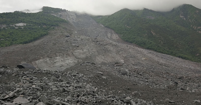
The team has been tracking the deadly event that occurred in Sichuan province, China in June, when a massive landslide struck Xinmo Village, Maoxian County, killing several people and destroying more than 40 homes. Three days later, a second landslide hit Xinmo Village and almost at the same time, a third landslide occurred in Shidaguan Town, 20km away from Xinmo Village.
Using ESA's Sentinel-1 satellite radar mission - which comprises a constellation of two polar-orbiting satellites, operating day and night in all-weather conditions - the research team was able to capture before and after images of the landslides.
Prof. Zhenhong Li, Professor of Imaging Geodesy at Newcastle University and member of the team, explains: "It is still hard, if not impossible, to detect a landslide using traditional techniques, especially in mountain areas. Using the satellite radar data, we were able to efficiently detect and map the active landslide over a wide region, identifying the source of the landslide and also its boundaries."
"Going forward, we can use this information to set up real-time monitoring systems - such as GPS, Beidou and Galileo - for those sites and whenever we detect abnormal behaviour, the system can send out an early warning message."
The collected satellite data provided vital information about the extent of the disaster which can be used to assess the damage and future risk in the area. According to Professor Li, their data suggests that the Maoxian landslide had been sliding for at least six months before it failed.
"When you consider this sort of timescale it suggests that a landslide Early Warning System is not only possible but would also be extremely effective. If we can detect movement at a very early stage then in many cases it is likely we would have time put systems in place to save lives", he stated.
The team ultimately hopes to use satellite technology to detect and map active landslides in the whole region of SW China, and then build a landslide database.
Source: Newcastle University
Want to read more like this story?
Landslides
Oct, 31, 2019 | Education

NASA maps landslides in central America caused by hurricane Eta
Nov, 10, 2020 | NewsNASA is currently mapping the landslides that were triggered during the passage of Hurricane Eta th...

About less deadly landslides!
Mar, 24, 2015 | NewsCould the Oso landslide have been avoided? Are there more landslide prone areas across the country a...

Landslide in Italy causes serious infrastructure damage
Dec, 03, 2013 | NewsA shallow landslide occurred in the Italian town of Montescaglioso last Tuesday, destroying roa...

Two landslides struck Indonesia: At least 13 casualties
Jan, 10, 2021 | NewsAt least 13 people have been reported dead after 2 major landslides struck in Indonesia. The ground...
Video: NASA generated landslide map reveals most landslide prone areas!
Apr, 22, 2015 | NewsRain-induced landslides have hit a death toll of nearly 20,000 since 2007. For an overview of the la...

Real time warning system for landslides
Aug, 09, 2018 | NewsA state-of-the-art system that is capable of warning people before landslides occur will be installe...

Citizen scientists at NASA’s service, for the creation of the largest landslide database
May, 24, 2018 | NewsThe aim is to get a better understanding of landslides with every report made Landslides ca...

Massive landslide in western India, killing 25, attributed to extensive deforestation
Jul, 31, 2014 | NewsAfter two days of incessant rain, reaching 10.8 centimeters, an entire village in Pune district...
On This Day
July 16th 1965
READ MORE
Related Video

Trending

New crustal stress map of North America

Using Terzaghi’s Equation in Foundation Design

Parameters Variation: Model Customization and Sensitivity Analyses

UK geothermal projects expand from Cornwall power to Birmingham heating
Asbestos remains a deadly infrastructure risk across the UK

Major earthquake in southern Philippines causes deaths and widespread damage