NASA maps landslides in central America caused by hurricane Eta

NASA is currently mapping the landslides that were triggered during the passage of Hurricane Eta through Central America.
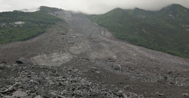
Hurricane Eta struck in early November 2020 and was one of the most powerful natural disasters to hit Central America in a long time period. It initiated as a tropical wave in the Caribbean Sea and then increased its intensity impacting many countries including Nicaragua, Honduras, Guatemala, Costa Rica and El Salvador.
Heavy rainfalls resulted in floods that caused severe damage to infrastructure and triggered many landslides. Many people were reported dead and numerous went missing. Moreover, a big proportion of the local population was forced to evacuate the affected regions. According to Unicef, more than 1.2 million children across Central America have been impacted by the hurricane. Most of the victims are currently accommodated in temporary shelters where the risk of COVID-19 infection is also high.
Currently, NASA is analyzing satellite imagery data to map the landslides that were triggered during the catastrophic event. Regions were mapped using NASA's SALaD (Semi-Automatic Landslide Detection) system which utilized images from Sentinel-2 satellite of the European Space Agency ESA. The system uses a machine learning algorithm to detect ground deformations and identify slides.
The research team has also developed a landslide prediction tool that uses a computer model to derive potential landslide phenomena. Comparing the predictions made with the model and the actual data, scientists found that many landslides were indeed successfully predicted. The model was developed by NASA’s Landslide Hazard Assessment for Situational Awareness (LHASA).
Among the detected ground failures, the team found a vast mudslide that struck the village of Queja in Guatemala and buried more than 100 villagers under its debris. Around 25 residences were also shallowed by the slide. The total number of casualties is still unknown. In fact, the system found around 30 landslides in the vicinity of the large slide.
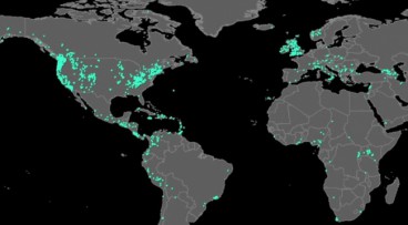
According to NASA officials, fortunately, many of the detected landslides occurred in remote regions where human infrastructure could not be impacted. Based on the prediction model that the team developed, an assessment map that utilized the landslide hazard and the population density as inputs to derive the entire potential risk that a region experienced during the incident, was created (the map can be found below).
The model uses rainfall intensity data from NASA's GPM mission and incorporates regional information including vegetation, the type of bedrock in-situ and the inclination of the slopes. “Within those areas, we can look at high-resolution imagery later to see if the landslides occurred and map the extent. It's helpful to have these two systems (referring to the prediction and the detection system) work in tandem," Robert Emberson, an associate scientist with Universities Space Research Association (USRA) working on the development of the LHASA model, stated.
Image Gallery

Want to read more like this story?
Landslides
Oct, 31, 2019 | Education
Video: NASA generated landslide map reveals most landslide prone areas!
Apr, 22, 2015 | NewsRain-induced landslides have hit a death toll of nearly 20,000 since 2007. For an overview of the la...

Storm Eta impacts Central America: numerous casualties
Nov, 05, 2020 | NewsTropical storm Eta has caused severe issues including floods and landslides in Central America resu...

Two landslides struck Indonesia: At least 13 casualties
Jan, 10, 2021 | NewsAt least 13 people have been reported dead after 2 major landslides struck in Indonesia. The ground...
Can satellites be used as an early warning system for landslides?
Aug, 04, 2017 | NewsA joint team of researchers from Newcastle University (UK), Chengdu University of Technology, Tongji...

Citizen scientists at NASA’s service, for the creation of the largest landslide database
May, 24, 2018 | NewsThe aim is to get a better understanding of landslides with every report made Landslides ca...

NASA partners with Pacific Disaster Center on new landslide hazard assessment and warning system
Oct, 26, 2023 | NewsA collaboration between NASA and University of Hawaii’s Pacific Disaster Center (PDC) was recently...

About less deadly landslides!
Mar, 24, 2015 | NewsCould the Oso landslide have been avoided? Are there more landslide prone areas across the country a...

Landslides struck Nepal: At least 11 casualties
Sep, 13, 2020 | NewsAt least 11 people have been reported dead and many more are still missing after a series of landsl...
On This Day
July 18th 1995
READ MORE
Related Video

Trending

Embankment Collapse on NH-66 in Kooriyad Triggers Engineering and Oversight Review

Fehmarnbelt tunnel advances with first element ready for immersion

Geotechnical Engineering 2032 Boom: Trends, Challenges, and Emerging Opportunities

Emergency protocols activated following offshore 7.7 magnitude earthquake in Japan
Tailrace tunnel breakthrough advances Australia’s largest renewable project

A Legacy of Leadership, Mentorship & Service: Gary L. Seider P.E.