What caused the massive landslide in California's Big Sur
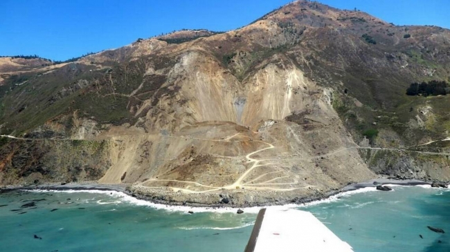
Scientists have conducted detailed investigation about the causes of the Mud Creek major landslide in Big Sur, California, about 2 years ago.
The landslide occurred on February 2017 covering the Pacific Coast Highway, a vital road network for Big Sur, with debris. Fortunately, officials had closed the road since January as smaller slides had already occurred.
It took 14 months and about $54 million to restore the damage and re-open the road.
Researchers at NASA's Jet Propulsion Laboratory (JPL) in Pasadena, California, and collaborating institutions investigated the causes of the failure.
It's not the first time that Mud Creek landslide troubles scientists. It was a well-known slide that was considered "stable" with a slow creeping pace downhill. However, the catastrophic collapse was not anticipated.
According to the researchers, drought and extreme rainfalls triggered the disastrous incident. The team found that the landslide was sliding at a rate of 17cm per year since 2009. They used a technique called interferometric synthetic aperture radar processing (InSAR) and data from an airborne JPL instrument called the Uninhabited Airborne Vehicle Synthetic Aperature Radar.
The region suffered a 5-year drought before 2017. However, the failure occurred after a persistent rainfall that lasted several days. The team used a computer model to evaluate the impact of water replacing air between soil particles. The presence of water in the soil alters the stress distribution destabilizing the slope and triggering landslides such as the one in Bug Sur.
Researchers tried to find out whether InSAR data could aid in predicting similar incidents. The team utilized images from the Mud Creek slide and two others, currently stable, landslides with similar soil properties. "We thought if we compared these two cases that didn't fail to the one that did, we might find some characteristic velocity pattern that would be a warning that a slide was going to fail catastrophically," Alexander Handwerger, a NASA postdoctoral fellow doing research at JPL. They found that all the stable landslides slightly accelerated after the rainfalls but, in contrast to the Mud Creek slide, the others slowed down and stabilized again.
Mr. Handwerger stated that they need more data in order to fully understand the mechanism of such failures. "We think that second speed-up may be a signal of interest, but we only have this one case. Since we now know that stable landslides in this region can fail catastrophically and we have good data coverage here, our plan is to monitor this whole stretch of the Pacific Coast Highway and look for these unusual velocity changes. If we get enough examples, we can start to actually figure out the mechanisms that are controlling this behavior."
|Source: Jpl.nasa.gov
Want to read more like this story?
Landslides
Oct, 31, 2019 | Education

Landslide swept away section of Highway 1 in California
Feb, 08, 2021 | NewsA 45-meter section of California's Highway 1 has been swept away by a large landslide. Highway 1 is...

Massive landslide buries part of California highway (video)
May, 24, 2017 | NewsPart of the mountainside went off into the Pacific Ocean, covering up a big part of scenic Highway 1...

NASA maps landslides in central America caused by hurricane Eta
Nov, 10, 2020 | NewsNASA is currently mapping the landslides that were triggered during the passage of Hurricane Eta th...

Quantifying the slip rate of a remote and creeping landslide
Jun, 03, 2020 | NewsA study, recently published in Nature Communications, presents a new technique for quantifying the...

Video: NASA generated landslide map reveals most landslide prone areas!
Apr, 22, 2015 | NewsRain-induced landslides have hit a death toll of nearly 20,000 since 2007. For an overview of the la...

Two landslides struck Indonesia: At least 13 casualties
Jan, 10, 2021 | NewsAt least 13 people have been reported dead after 2 major landslides struck in Indonesia. The ground...

Landslide in Italy causes serious infrastructure damage
Dec, 03, 2013 | NewsA shallow landslide occurred in the Italian town of Montescaglioso last Tuesday, destroying roa...

5 years from the tremendous Oso landslide
Mar, 26, 2019 | NewsThe families of the unfortunate victims that lost their lives due to the catastrophic Oso landslide...
On This Day
July 28th 1976
READ MORE
Related Video

Trending

Dubai approves $9.2bn fully underground gold line metro

How to prevent copper wire theft from light poles
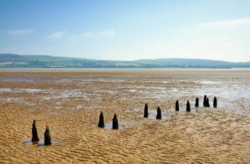
The quicksand of Morecambe Bay

Model Structures and Visualize Structural Forces
Rapid Drawdown in Dam and Levee Design: A Hydrogeologic Perspective in Slide2
Major wastewater tunnel procurement begins in southern Sweden