5 years from the tremendous Oso landslide
The families of the unfortunate victims that lost their lives due to the catastrophic Oso landslide held a 5-year memorial ceremony.
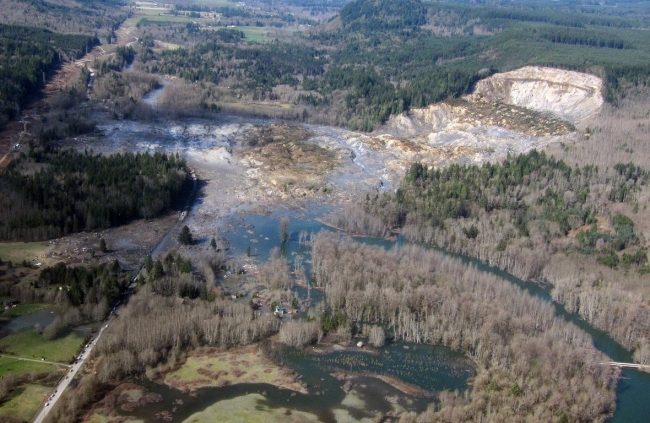
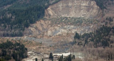
The slide, known as the SR 530 landslide, occurred on March 22, 2014 and destroyed a riverside in Oso. According to the U.S. Geological Survey (USGS), it was triggered by heavy rainfall that saturated the soil. Logging may also have contributed to the failure.
The mudslide which was the deadliest in the history of the United States, was propagating for years. "That landslide mass prior to March 22 was really in some sense poised to fail. It was really unstable," Joseph Wartman, an engineer at University of Washington, stated.
Under these circumstances, continuous rainfall that saturated the soil was enough to trigger the landslide which affected the towns of Oso and Darrington and covered an area of about 2.60km2. 40 houses and other structures were buried near State Route 30. Unfortunately, 43 people lost their lives in the Steelhead Haven community.
On March 22, 2019, people related to the victims gathered together to honor their memory. They held a moment of silence at 10:37 a.m., the actual time of the landslide. A bronze sculpture of mailboxes was dedicated to the victims and survivors. Still, the community insists on building a permanent structure that will survive much longer. "We need something that lets that legacy that each one of them lived to live on," said Dayn Brunner, a local who lost a sister in the tragic incident. A committee is trying to raise a $6 million fund for the design and construction of such a structure.
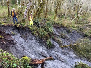
USGS is monitoring the landslide since 2014. Right after the incident, USGS provided instruments including 3 portable packages called "spiders" which contain high-accuracy GPS to alert people if soil movement is detected. Moreover, USGS has been conducting field survey and laboratory testing to determine the causes of the landslide's high mobility. Scientists believe that those findings will help in the development of models that would better predict the behavior of such landslides.
Regarding the mechanism of the slide's failure, USGS suggests that the slope collapsed in two stages over a one-minute period. During the 2nd stage, the liquefaction of a saturated sand layer caused high acceleration of the moving mass that quickly covered the river valley.
For more information about Oso landslide, click the video below.
Sources: Nationalgeographic.com, USGS.gov, Q13fox.com
Media
- Deadly mudslide: Eight killed, several missing in Washington town
Want to read more like this story?
Landslides
Oct, 31, 2019 | Education

How possible is a next Oso landslide event?
Feb, 27, 2015 | NewsSince the Oso landslide, the emerging question in many meetings, panel discussions and brainstorming...

Two landslides struck Indonesia: At least 13 casualties
Jan, 10, 2021 | NewsAt least 13 people have been reported dead after 2 major landslides struck in Indonesia. The ground...

Landslides struck Nepal: At least 11 casualties
Sep, 13, 2020 | NewsAt least 11 people have been reported dead and many more are still missing after a series of landsl...
Slow-moving landslide discovered near the 2014 Oso landslide site in Washington
Apr, 09, 2017 | NewsSigns of the landslide were first discovered on Tuesday, April 4 by Washington's Department of Trans...

Poorly Engineered Roads in Nepal Trigger Landslides
Aug, 05, 2016 | NewsThe 2016 monsoon season has been particularly severe in Nepal and has resulted in mass flooding and...
Oso Washington Landslide Risk Goes Back Decades
Jan, 11, 2016 | NewsIn March, 2014, 40 people perished in a landslide in Oso, Washington. Based on research from t...

About less deadly landslides!
Mar, 24, 2015 | NewsCould the Oso landslide have been avoided? Are there more landslide prone areas across the country a...

Video: NASA generated landslide map reveals most landslide prone areas!
Apr, 22, 2015 | NewsRain-induced landslides have hit a death toll of nearly 20,000 since 2007. For an overview of the la...
On This Day
July 16th 1965
READ MORE
Related Video

Trending

Life after gINT - Rethinking geotechnical data management for a new era

Is Africa gradually splitting into two sections?

Stop Guessing, Start Designing: Introducing Support Designer in Slide2


Alert level is raised in Mexico as the Popocatépetl volcano spews ash and gas

Emergency ground stabilisation protects rail works near Salford Central