News
Featured News


Satellite-Based News
Mexico City’s sinking crisis mapped by next-generation satellite
- May, 08, 2026
- Satellite-Based Settlements News On Products & Services Geology Highlights Other News
- Mexico
- Authored by: Geoengineer.org
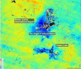
Mexico City’s long-documented subsidence problem is receiving renewed attention after the NASA-ISRO Synthetic Aperture Radar (NISAR) mission mapped areas of the metropolitan region sinking by more tha...
Read More
Bentley Systems Announces 2026 Year in Infrastructure Event and YII Awards Honoring the World’s Most Innovative Use of Infrastructure Engineering Software
- Mar, 30, 2026
- Numerical & Constitutive Modeling Finite Element / Finite Difference Geomatics Satellite-Based Risk & Reliability News On Projects / Industry News On Awards
- Authored by: Geoengineer.org
Awards build on a two-decade legacy of recognized innovation, setting the benchmark for excellence across the world’s most critical infrastructure assets. Bentley Systems, Incorporated (NASDAQ: BSY...
Read More
Satellite data indicate over 2,500 U.S. dams are in poor condition
- Dec, 21, 2025
- Dam Engineering Geomatics Satellite-Based Instrumentation Risk & Reliability News On Projects / Industry
- Authored by: Geoengineer.org
Dams across the United States are aging and underfunded, with geoscientists reporting that over 2,500 of the more than 16,700 structures in the country are classified as high hazard potentials and in...
Read More
Engineering implications from the 2025 geomagnetic storm
Space weather agencies have issued alerts for a severe geomagnetic storm expected to reach Earth in mid-November 2025. Forecasts indicate the potential for a G4 to G5 level event, driven by multiple...
Read More
After 700,000 years of silence, InSAR unveils that Iran’s Taftan volcano shows signs of awakening
- Oct, 16, 2025
- Satellite-Based Settlements Geology Highlights News On Research / Academia
- Iran
- Authored by: Geoengineer.org
The Taftan Volcano in southeastern Iran, long thought to be extinct, is showing signs of renewed activity after approximately 700,000 years of dormancy. Recent satellite data analyzed between July 20...
Read More
Sinking Cities: The U.S. Subsidence Crisis
- May, 26, 2025
- Settlements Satellite-Based Geomatics News On Publications News On Natural Disasters / Failures
- United States
- Authored by: Geoengineer.org
A recent study has revealed a trend affecting the stability of American urban infrastructure: land subsidence. Using high-resolution satellite radar data, researchers identified that all but three of...
Read More
Aral Sea Rebound: Satellite Radar Reveals Slow Uplift of Earth’s Crust
- Apr, 08, 2025
- Structural Geology Engineering Geology Satellite-Based Geoenvironmental Engineering News On Research / Academia Geology Highlights
- Aral Sea
- Authored by: Geoengineer.org
The drying of the Aral Sea—once the world’s fourth-largest saline lake—has long been a symbol of environmental loss. But a new satellite-based study has uncovered a surprising geological reaction: th...
Read More
Radar Eyes on Peat: Mapping Hidden Landslide Risks Across Scotland
- Apr, 04, 2025
- Slope Stability Satellite-Based Soil Mechanics Settlements Geomatics Aerial News On Projects / Industry News On Research / Academia News On Natural Disasters / Failures
- United Kingdom
- Authored by: Geoengineer.org
Peatlands are more than just soft, soggy ground. In Scotland, they cover vast, remote, and ecologically significant areas—and they are increasingly the focus of environmental restoration efforts. Bu...
Read More
California’s Shifting Ground: NASA Unveils the Growing Landslide Crisis
- Mar, 06, 2025
- Satellite-Based Landslides News On Research / Academia News On Natural Disasters / Failures
- United States, California , Rancho Palos Verdes
- Authored by: Geoengineer.org
The Palos Verdes Peninsula in Southern California has long been home to slow-moving landslides. For decades, the region's landscape has inched toward the Pacific, reshaping communities and infrastruc...
Read More
Satellite Technology and AI: The Future of Dam Monitoring and Disaster Prevention
- Feb, 27, 2025
- Dam Engineering Satellite-Based News On Projects / Industry News On Products & Services News On Research / Academia News On Natural Disasters / Failures
- Authored by: Geoengineer.org
Dams are among the most critical pieces of infrastructure worldwide, yet their failures can be catastrophic, leading to loss of life, economic devastation, and environmental destruction. Traditional...
Read More