News
Featured News


Geomatics News
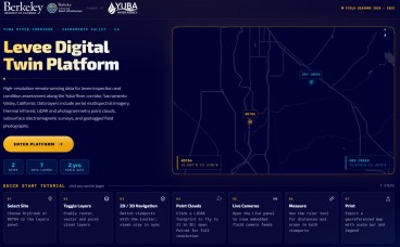
Levee Digital Twin Platform Launches for California's Yuba River Corridor
- Jun, 11, 2026
- Levees Data Management Geomatics Lidar Aerial Unmanned Aerial Systems News On Projects / Industry News On Research / Academia
- Authored by: Geoengineer.org
Researchers at UC Berkeley, funded by Yuba Water, have unveiled the Levee Digital Twin Platform — a comprehensive, interactive monitoring system built for levee inspection and condition assessment alo...
Read More
Bentley Systems Announces 2026 Year in Infrastructure Event and YII Awards Honoring the World’s Most Innovative Use of Infrastructure Engineering Software
- Mar, 30, 2026
- Numerical & Constitutive Modeling Finite Element / Finite Difference Geomatics Satellite-Based Risk & Reliability News On Projects / Industry News On Awards
- Authored by: Geoengineer.org
Awards build on a two-decade legacy of recognized innovation, setting the benchmark for excellence across the world’s most critical infrastructure assets. Bentley Systems, Incorporated (NASDAQ: BSY...
Read More
Satellite data indicate over 2,500 U.S. dams are in poor condition
- Dec, 21, 2025
- Dam Engineering Geomatics Satellite-Based Instrumentation Risk & Reliability News On Projects / Industry
- Authored by: Geoengineer.org
Dams across the United States are aging and underfunded, with geoscientists reporting that over 2,500 of the more than 16,700 structures in the country are classified as high hazard potentials and in...
Read More
Sinking Cities: The U.S. Subsidence Crisis
- May, 26, 2025
- Settlements Satellite-Based Geomatics News On Publications News On Natural Disasters / Failures
- United States
- Authored by: Geoengineer.org
A recent study has revealed a trend affecting the stability of American urban infrastructure: land subsidence. Using high-resolution satellite radar data, researchers identified that all but three of...
Read More
How OpenGround helped Schnabel Engineering build a ground-breaking project platform
- May, 07, 2025
- Data Management Geomatics Engineering Geology Dam Engineering News On Projects / Industry News On Software
- Authored by: Geoengineer.org
Schnabel Engineering — a major geotechnical, dam, and tunnel engineering service provider — was excited to start simplifying, optimizing, and digitalizing its data management system. Particularly sin...
Read More
Smarter Sampling, Safer Terrain: How Machine Learning Is Redefining Landslide Risk Mapping
- Apr, 10, 2025
- Landslides Geomatics Slope Stability News On Research / Academia
- India, Marango Rangarik
- Authored by: Geoengineer.org
Landslides remain one of the most devastating natural hazards in mountainous and hilly regions across the globe. With steep topography, variable climate conditions, and increasing human activity like...
Read More
Radar Eyes on Peat: Mapping Hidden Landslide Risks Across Scotland
- Apr, 04, 2025
- Slope Stability Satellite-Based Soil Mechanics Settlements Geomatics Aerial News On Projects / Industry News On Research / Academia News On Natural Disasters / Failures
- United Kingdom
- Authored by: Geoengineer.org
Peatlands are more than just soft, soggy ground. In Scotland, they cover vast, remote, and ecologically significant areas—and they are increasingly the focus of environmental restoration efforts. Bu...
Read More
45% of Himachal Pradesh at Risk of Landslides and Floods – What Can Be Done?
- Feb, 19, 2025
- Landslides Engineering Geology Visualization Risk & Reliability Geomatics News On Research / Academia News On Natural Disasters / Failures
- India
- Authored by: Geoengineer.org
A recent geospatial study has revealed that over 45% of Himachal Pradesh is highly susceptible to landslides, floods, and avalanches. Researchers conducted hazard mapping to identify high-risk zones...
Read More
Geotechnical news recap of December 2024 now on YouTube!
- Jan, 09, 2025
- Landslides Other Geotechnical Settlements Earthquake Reconnaissance Geotechnical Earthquake Engineering Engineering Seismology Forensics Aerial Geomatics Satellite-Based Dam Engineering Foundation Design / Construction
- Authored by: Geoengineer.org
Namely, these were:
Read More
Space-Based Insights: Early Signs of Kakhovka Dam Collapse Detected
- Dec, 20, 2024
- Aerial Geomatics Satellite-Based Dam Engineering Forensics Other Geotechnical News On Research / Academia News On Natural Disasters / Failures News On Products & Services
- Ukraine
- Authored by: Geoengineer.org
The collapse of the Kakhovka Dam in Ukraine on June 6, 2023, was a catastrophic event that devastated water management systems and hydroelectric power generation. While the exact cause has been linke...
Read More