The impact of coastal flooding on traffic resilience: The case of San Francisco Bay Area
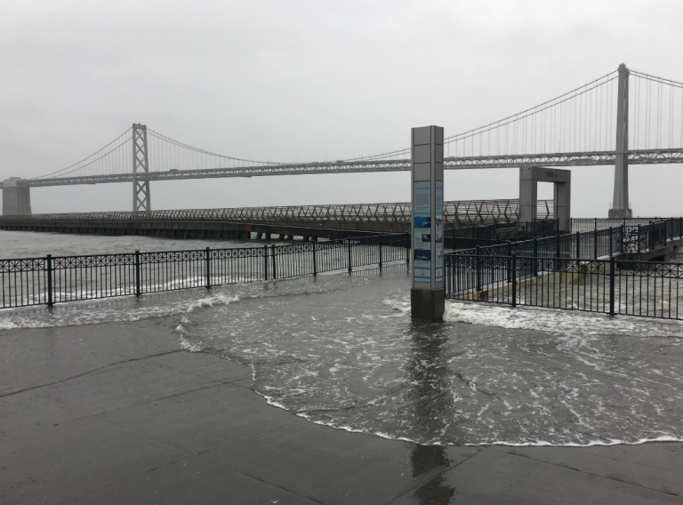
A new study suggests that coastal flooding and seawater level rise severely impact the traffic network and safety in San Francisco Bay Area, USA.
Seal level rise in California will potentially become a severe problem in the following decades. In fact, the water level is expected to rise by more than 2 meters by 2100 and flooding could become a daily issue for numerous people. In financial terms, about $8-$10 billion of infrastructure could be underwater within the next 30 years and an additional $8-$10 billion worth of property will be at risk of tides.
Traffic resilience is practically the ability of a transport system to withstand congestion. Coastal floods and high seawater levels are becoming more frequent in regions with relatively low altitudes due to the impact of climate change. At the same time, many coastal cities experience a population boost and accumulate numerous people and resources. Coastal floods can result in three types of impact: 1. Completely blocked roads where commuting is totally restricted, 2. Delays where some roadways remain functional and travelers need to use reroutes and 3. Increase of road and pedestrian accidents as a result of high vehicle flows in local roads.
San Francisco Bay is a highly populated region that has a congested road network. Nowadays, minor coastal flood incidents cause disproportional traffic problems that 1. increase the travel times and 2. result in more accidents.
In such a stressed system, disruptions can readily take place when a natural disaster (such as a flood) strikes. The impact of those disruptions can be direct or indirect. The direct consequences refer to the damage caused to roads and infrastructure whilst indirect damage is associated with travel delays, increased accidents and employee absences. The new study focuses on the indirect impacts of seawater rise and flood events to evaluate the latter.
The findings of the study suggest that, during coastal flooding, travel time delays increase in areas where the road network does not offer alternative routes to follow while accidents rise in regions that have a well-developed secondary network and traffic flows quickly shift. In addition, accidents are more pronounced in low water level rise while more delays were detected in high water levels. The authors suggest that, given the findings, accidents are more of a threat than delays at "low-to-moderate water levels".
In addition, flooding of major highways sends commuters to local roads in residential areas nearby. The neighborhoods around highways are historically less developed in terms of infrastructure, thus, road safety is further compromised.
Sources: LAO, Kasmalkar and Suckale (2021), Stanford
Image Gallery

Media
- Rising Sea Levels To Flood Thousand OF Bay Area
- KPIX CBS
Want to read more like this story?

U.S. coastal areas will be frequently flooded if sea-level rise is not mitigated
Apr, 16, 2020 | NewsAccording to a new study, coastal cities in the United States may experience flooding incidents eve...

Report indicates that sea level rise will make many US coastal areas prone to flooding
Jul, 23, 2014 | NewsNon-profit's organization survey and analyses on climate change, point out that South and...

Portsmouth Coastal Scheme: colossal coastal protection project about to begin
Jan, 30, 2015 | NewsAn extended coastal protection project is about to begin in Portsmouth, UK, covering nearly 13km of...

Earthquakes can aggravate sea water level rise
Jun, 21, 2019 | NewsAccording to a new study published in the Journal of Geophysical Research: Solid Earth, earthquakes...

Papua, New Guinea: Three landslides caused at least 23 fatalities - extreme weather conditions persist
Mar, 19, 2024 | NewsSince the 19th of March heavy rainfall caused extensive flooding and landslides in various parts of...

The Rising Threat of Groundwater Flooding: Risks and GeoEngineering Solutions
Feb, 28, 2025 | NewsGroundwater flooding is an often-overlooked hazard, but as climate change intensifies, its risks ar...

Nor’easter threatens U.S. east coast with major flooding and coastal erosion
Oct, 11, 2025 | NewsA powerful coastal storm, classified as a nor’easter, is rapidly intensifying off the southeastern...

China floods show how typhoons test reservoirs, roads and cities
Jul, 11, 2026 | NewsTyphoon Maysak has killed at least two people in southern China and forced tens of thousands to evac...

Study of future coastal flooding impact on river delta populations
Sep, 29, 2020 | NewsA new study evaluates the impact of coastal flooding caused by climate change on human population....
On This Day
July 21st 0365
READ MORE
Related Video

Trending

Dubai approves $9.2bn fully underground gold line metro

How to prevent copper wire theft from light poles
The quicksand of Morecambe Bay

Model Structures and Visualize Structural Forces
Rapid Drawdown in Dam and Levee Design: A Hydrogeologic Perspective in Slide2
Emergency ground stabilisation protects rail works near Salford Central