The Kentucky Geological Survey is compiling a landslide inventory database to document the distribution and geological characteristics of landslides across Kentucky state and to provide easy access to the information. The database is similar to several others competed as part of a Landslide Inventory Pilot Project by the United States Geological Survey (USGS).
The Kentucky Geological Survey is compiling a landslide inventory database to document the distribution and geological characteristics of landslides across Kentucky state and to provide easy access to the information. The database is similar to several others competed as part of a Landslide Inventory Pilot Project by the United States Geological Survey (USGS).
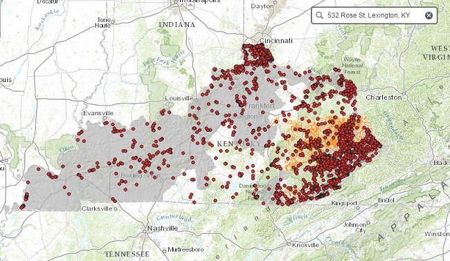
The database is being used to create an online landslide information map. The database documents landslides using geographic information system (GIS) layers including topography, topography with a hillshade feature, and an aerial layer. The database can be found at kgs.uky.edu. Each landslide event is classified and documents the county, coordinates, type of failure, and failure year, among other available relevant information. Most states surveys are available in a non-digital nature, and one of the challenges facing USGS in this pilot project is providing a forum for the information that is readily available. Hard copy reports and maps must be scanned and successfully categorized within the GIS layer format.
More information on the Landslide Inventory Pilot Project can be found at landslides.usgs.gov.
Nearby News
Want to read more like this story?
Landslides
Oct, 31, 2019 | Education
Arizona Geological Survey: New landslide inventory project about to begin
Apr, 09, 2015 | NewsAs a result of the continuing landslides and their detrimental effects on property and infrastructur...

Citizen scientists at NASA’s service, for the creation of the largest landslide database
May, 24, 2018 | NewsThe aim is to get a better understanding of landslides with every report made Landslides ca...

Video: NASA generated landslide map reveals most landslide prone areas!
Apr, 22, 2015 | NewsRain-induced landslides have hit a death toll of nearly 20,000 since 2007. For an overview of the la...

About less deadly landslides!
Mar, 24, 2015 | NewsCould the Oso landslide have been avoided? Are there more landslide prone areas across the country a...

Washington employs LiDAR technology against landslide risk
Jan, 25, 2017 | NewsWashington's Department of Natural Resources (DNR) is making use of the best technology available to...

5 years from the tremendous Oso landslide
Mar, 26, 2019 | NewsThe families of the unfortunate victims that lost their lives due to the catastrophic Oso landslide...

GSI Develops Digitised Database of Landslides
Jul, 13, 2015 | NewsMany landslides and land subsidence have been recorded. Dozens of landslides have been fatal, and th...

How possible is a next Oso landslide event?
Feb, 27, 2015 | NewsSince the Oso landslide, the emerging question in many meetings, panel discussions and brainstorming...
On This Day

Related Video

Trending

China's Three Gorges Dam under pressure: Flood hazard downstream

Functional requirements of foundation structures


Landslide in Papua New Guinea: At least 12 people dead


Emergency ground stabilisation protects rail works near Salford Central