Arizona Geological Survey: New landslide inventory project about to begin
As a result of the continuing landslides and their detrimental effects on property and infrastructure, the Arizona Geological Survey (AZGS) is about to begin a new landslide inventory project. The new project is going to help residents, state and federal authorities to efficiently prepare and deal with the consequences of future landslides.
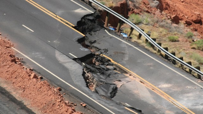
Over a time frame of 10 years, Arizona was severely hit by landslides, damaging its road network and many buildings, with the most recent being a slide event along the Echo Cliffs south of Page, causing the closure of a 23-mile section of the road connecting Bitter Springs and Page. Repair works took 2 year to complete and cost around $25million.
In response to the landslide induced damage to property and infrastructure, the Arizona Geological Survey (AZGS) is about to start a two-year project with the purpose to create an inventory of landslides across the state. The project aims in inventorying historic and pre-historic landslides and creating a database to be used by emergency planners in the state. Scientists will initially focus on the most densely populated areas and major transportation routes, which are the locations presenting the highest risk, however landslide hazards are continuously increasing as land development activities expand towards mountainous locations and wildfires in combination with monsoon rains are mobilizing debris-flows. Dr Ann Youberg an AZGS research geologist specifically stated with regards to the importance of the project: "Our current understanding of the nature and extent of landslide activity in Arizona is rudimentary, and thus it is very difficult to assess the hazards associated with landslides."
The final deliverable of the specific project will be an online interactive Landslide Inventory Database of known and newly identified landslides which will help in the development of hazard and risk map assessments to be used in the effective protection of property and infrastructure.
Source: PaysonRoundUp
Want to read more like this story?
Landslides
Oct, 31, 2019 | Education

Learning from Landslides
Jun, 10, 2015 | NewsThe Kentucky Geological Survey is compiling a landslide inventory database to document the distribut...

Citizen scientists at NASA’s service, for the creation of the largest landslide database
May, 24, 2018 | NewsThe aim is to get a better understanding of landslides with every report made Landslides ca...

About less deadly landslides!
Mar, 24, 2015 | NewsCould the Oso landslide have been avoided? Are there more landslide prone areas across the country a...
Video: NASA generated landslide map reveals most landslide prone areas!
Apr, 22, 2015 | NewsRain-induced landslides have hit a death toll of nearly 20,000 since 2007. For an overview of the la...

Washington employs LiDAR technology against landslide risk
Jan, 25, 2017 | NewsWashington's Department of Natural Resources (DNR) is making use of the best technology available to...

Risk assessment of rainfall-induced landslides in urban regions
Aug, 09, 2021 | NewsA new study suggests that urban areas are more prone to rainfall-induced landslides compared to rur...

Urban areas at greater risk for landslides due to the effects of precipitation
Aug, 09, 2021 | NewsA new study indicates that urbanized areas are more prone to landslides caused by precipitation tha...

Amtrak rail corridor major reliability upgrade undertaken by WSDOT
Jan, 22, 2015 | NewsWSDOT is currently undertaking a landslide prevention project along its Amtrak Cascades rail corrido...
On This Day
July 16th 1965
READ MORE
Related Video

Trending

Life after gINT - Rethinking geotechnical data management for a new era

Is Africa gradually splitting into two sections?

Stop Guessing, Start Designing: Introducing Support Designer in Slide2

Alert level is raised in Mexico as the Popocatépetl volcano spews ash and gas
Tailrace tunnel breakthrough advances Australia’s largest renewable project

A Legacy of Leadership, Mentorship & Service: Gary L. Seider P.E.