GEO5 2021 - New Features and Improvements Sponsored
- Jan, 11, 2021
- Data Management Retaining Walls Foundation Design / Construction Geophysics Geotechnical Earthquake Engineering Ground Improvement Groundwater & Seepage Site Characterization & In-Situ Testing (General) Rock Engineering Slope Stability Underground Structures News On Software
- Authored by: Geoengineer.org
A new edition of GEO5 is released once a year and users of the newest edition always have access to all new upgrades and updates of that edition. The edition is maintained for 2-3 years after release, even after a newer edition is introduced. Fine Maintenance subscribers always have access to new editions. Other users have the opportunity to buy the newest edition as a Single Upgrade.
New Annexes in all GEO5 programs
- Annexes are a new tool, enabling to enter texts, import and edit images, PDF files and include them in the output protocol. Imported Annexes are stored within the program data.
- Take a look at how to work with Annexes in the GEO5 programs.
Stratigraphy - Earthworks
- New module Earthworks brings construction stages into Stratigraphy. It allows to model foundation pits, roads, railways, quarries, slopes and calculate the volumes of earthworks or terrain movements. More about the Earthworks.
- See how to model park landscaping using the Earthworks module.
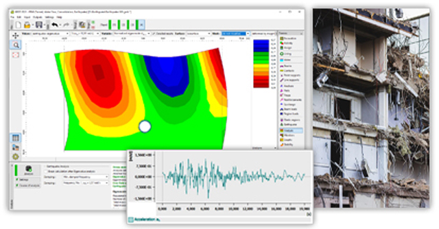
FEM - Earthquake
- New module Earthquake performs dynamic analysis of geotechnical structures loaded by earthquake-induced ground motion. More about the module.
New features in GEO5 programs
- Stratigraphy – Coordinate Systems - More than 6000 worldwide coordinate systems are implemented. These coordinates can be converted to GPS and visualized on Google Maps.

- Sheeting Check – Lagging and Walers - Design of timber or concrete lagging and steel or concrete walers is now available.

- Stratigraphy - Data Import/Export - Export and import field test data in XML, XLS and other formats. Data can be loaded into templates.
- All programs - Import/export DXF, DWG - New DWG import option. Enhanced options of the DXF import/export.
- Slope Stability – Water Surcharge - It is now possible to enter water surcharge above the terrain, which enables to model for example water reservoirs.
- Settlement - Graph of consolidation - Improved graph of consolidation in the Settlement program.
- Prefab wall - General shapes of blocks - General shapes of blocks can be defined by merge function.
Source: Fine Software New Version
Media
Want to read more like this story?

GEO5 2023 - New Edition released!
Jan, 04, 2023 | NewsThe new GEO5 2023 Edition has been just released with new data collection options and many improvem...

GEO5 2022 - New Edition released!
Dec, 16, 2021 | NewsThe new Edition brings many improvements that allow working according to the principles of geotechn...

GEO5 Edition 2020 just released by Fine Software
Dec, 17, 2019 | NewsA new edition of GEO5 is released once a year, always on November 1st. Users of the newest edition...

GEO5 new 2022 release update!
May, 27, 2022 | NewsThe new GEO5 2022 update brings many improvements within the programs and introduces a new Slope St...

GEO5 New 2021 Update
May, 26, 2021 | NewsThe latest GEO5 2021 update brings many improvements! See what's new: Geological maps and source...

GEO5 2024 - New Edition released!
Jan, 12, 2024 | NewsNew 2024 GEO5 Edition with new Laboratory program and many improvements! GEO5 Laboratory Program La...

GEO5 2023 - New Update is released!
May, 17, 2023 | NewsMobile Application for Data Collection GEO5 Data Collector - the application for mobile devices (iO...

GEO5 Stratigraphy – Earthworks
Jan, 19, 2023 | Software
GEO5 2019 Spring Update - Tutorials and Documentation
Sep, 18, 2019 | NewsGEO5 is a software suite, providing solutions for the majority of geotechnical tasks. It consists o...
On This Day
July 17th 1588
READ MORE
Related Video

Trending

Quick Clay Failure on Norway’s E6 at Levanger

Keller North America announces recent leadership changes


Fulgurite: A rare phenomenon
Emergency ground stabilisation protects rail works near Salford Central