Geo-Mapping the Future: AI-Powered Solutions for Urban Liquefaction Risks


Sources: mdpi.com, structville.com
Want to read more like this story?

Numerical Modelling: On the Importance of an Appropriate Soil Model
Jul, 22, 2021 | EducationThe following was prepared by Dr. Ronald B.J. Brinkgreve, and first presented by Virtuosity. Numeri...

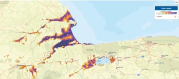
Scientists to map areas at risk from liquefaction (video)
Dec, 09, 2017 | NewsA team of researchers has been brought together under LIQUEFACT project to investigate and find solu...

An active fault zone poses a threat for infrastructure in Salt Lake City, Utah
Jun, 03, 2021 | NewsAccording to a new study, a complex fault system beneath Salt Lake City can pose a severe threat to...

Liquefaction and Earthquake Modelling in PLAXIS
Jun, 30, 2021 | EducationThe following was prepared by Dr. Ronald B.J. Brinkgreve, and first presented by Virtuosity. Geotec...
Numerical Modelling: Soil Test Facility Learning Tool
Aug, 09, 2021 | EducationThe following was prepared by Dr. Ronald B.J. Brinkgreve, and first presented by Virtuosity. In a p...
Landslide and liquefaction mapping becomes critical after major quakes
Jun, 29, 2026 | NewsRecent major earthquakes in Venezuela and the southern Philippines have highlighted an important les...

VertekCPT: All you need to know about Soil Liquefaction
Jul, 13, 2015 | NewsIn continuation to the previous article about Soil Shear Strength, which was published in VertekCPT...

Public release of the NASEM Report on Liquefaction Assessment
Feb, 02, 2017 | NewsThe National Academies of Science, Engineering & Medicine (NASEM) recently released a report of...

PLAXIS Soft Soil Modeling
Oct, 05, 2021 | EducationThe following was prepared by Dr. Ronald B.J. Brinkgreve, and first presented by Virtuosity. The te...
On This Day
July 20th 1940
READ MORE
Trending

New crustal stress map of North America

Using Terzaghi’s Equation in Foundation Design

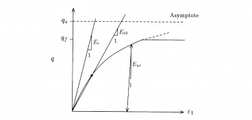
Parameters Variation: Model Customization and Sensitivity Analyses

UK geothermal projects expand from Cornwall power to Birmingham heating
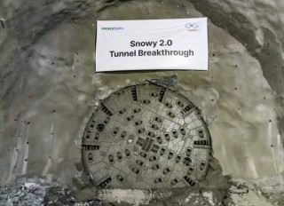
Tailrace tunnel breakthrough advances Australia’s largest renewable project
A Legacy of Leadership, Mentorship & Service: Gary L. Seider P.E.