Landslide and liquefaction mapping becomes critical after major quakes
Sources: eos.org, eos.org/thelandslideblog, earthquake.usgs.gov
Want to read more like this story?

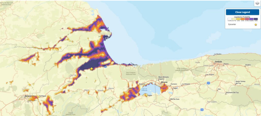
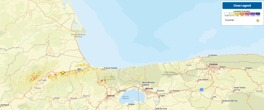
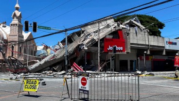
Venezuela earthquakes leave hundreds dead as rescue teams search collapsed buildings
Jun, 25, 2026 | NewsVenezuela has declared a state of emergency after two powerful earthquakes struck the country, causi...

Study suggests that smaller earthquakes generate most strong ground motions
Jan, 04, 2021 | NewsAccording to a new study, smaller earthquakes have caused the strongest shaking incidents in the vi...
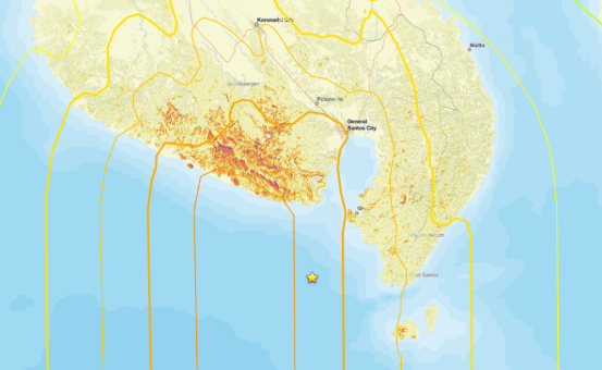
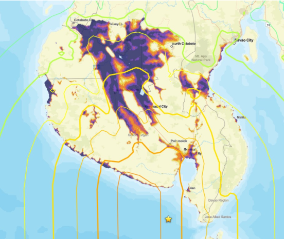
Major earthquake in southern Philippines causes deaths and widespread damage
Jun, 08, 2026 | NewsA powerful magnitude 7.8 earthquake struck off the coast of Mindanao in the southern Philippines, ki...

Earthquakes triggered by landslides
Jul, 02, 2020 | NewsIt is widely known that earthquakes can trigger disastrous landslides but, what about the opposite?...

Alaska rocked by M7.0 earthquake as aftershocks intensify, raising infrastructure risks
Dec, 07, 2025 | NewsA magnitude 7.0 earthquake struck near Yakutat, Alaska, triggering more than 160 aftershocks within...

Deep landslides triggered by the 1964 Alaska earthquake were not re-activated in the 2018 Anchorage earthquake
Oct, 29, 2019 | NewsAccording to a new study, published in Seismological Research Letters, the deep landslides that wer...

Second Major Earthquake hits Cephalonia island in Greece; causes significant damage; information hub established on GeoWorld; updates to follow
Feb, 03, 2014 | NewsA new Mw 5.7 earthquake hit Cephalonia at 5:08 am on February 3rd 2014, less than 10 days after the...

Geo-Mapping the Future: AI-Powered Solutions for Urban Liquefaction Risks
Oct, 08, 2024 | NewsAs cities expand, so does the need for robust disaster management, especially in earthquake-prone a...

Two powerful earthquakes hit China: Reports of 3 people dead
May, 21, 2021 | NewsTwo separate, strong earthquakes that struck in China have resulted in, at least, 3 fatalities. The...
On This Day
July 21st 0365
READ MORE
Related Video

Trending
Brownfield success: Engineering excellence starts below ground


Scripting Comes to RS3: Automate, Customize, and Accelerate Your 3D Modelling

2D and 3D Analysis of Retaining Systems

Mine waste dam failure in Myanmar caught on video

Stop Guessing, Start Designing: Introducing Support Designer in Slide2
Development program prepares new engineers for success