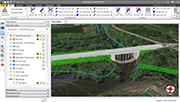
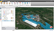
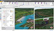
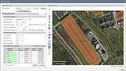
GeoHECRAS is an AutoCAD, MicroStation and ESRI ArcGIS compatible interactive 2D/3D graphical user interface data wrapper to the US Army Corps of Engineers HEC-RAS.
GeoHECRAS significantly speeds up HEC-RAS model creation and review, producing better and more accurate results. Rapidly construct HEC-RAS models from a variety of data sources. Accelerate engineering workflow and streamline analysis review. Compute water surface profiles for steady and unsteady flow models, bridge and culvert roadway crossings, FEMA floodplain encroachments, stream restorations, inline reservoir structures, off-channel storage areas, and much more.
This feature is only available for software listings at the Advanced or Lead Sponsorship Level. Each software provider can upgrade the sponsorship level of their software listing by visiting the sponsorship levels page.
Geoengineer.org uses third party cookies to improve our website and your experience when using it. To find out more about the cookies we use and how to delete them visit our Cookies page. Allow cookies