News
Featured News


Satellite-Based News

Geotechnical news recap of December 2024 now on YouTube!
- Jan, 09, 2025
- Landslides Other Geotechnical Settlements Earthquake Reconnaissance Geotechnical Earthquake Engineering Engineering Seismology Forensics Aerial Geomatics Satellite-Based Dam Engineering Foundation Design / Construction
- Authored by: Geoengineer.org
Namely, these were:
Read More
Space-Based Insights: Early Signs of Kakhovka Dam Collapse Detected
- Dec, 20, 2024
- Aerial Geomatics Satellite-Based Dam Engineering Forensics Other Geotechnical News On Research / Academia News On Natural Disasters / Failures News On Products & Services
- Ukraine
- Authored by: Geoengineer.org
The collapse of the Kakhovka Dam in Ukraine on June 6, 2023, was a catastrophic event that devastated water management systems and hydroelectric power generation. While the exact cause has been linke...
Read More
Geotechnical news recap of November 2024 now on YouTube!
- Dec, 03, 2024
- Landslides Reconnaissance Of Natural Disasters Geoenvironmental Engineering Other Geotechnical Other Energy Geothermal Lidar Satellite-Based Geo-Energy
- Authored by: Geoengineer.org
You can now find Geoengineer.org's latest news recap video on YouTube, which includes what we found to be the most interesting geotechnical news of November 2024. Namely, these were: 1) Historic...
Read More
Pioneering Geotechnical Advances to Secure the Himalayan Landscape
- Nov, 29, 2024
- Geomatics Aerial Satellite-Based Lidar Landslides News On Research / Academia News On Natural Disasters / Failures
- Himalayas
- Authored by: Geoengineer.org
The Himalayan region faces a growing threat from landslides triggered by extreme precipitation, rapid population growth, and infrastructure development. Events like the catastrophic 2021 Chamoli disa...
Read More
Unveiling Ancient Settlements in Colombia with Advanced Remote Sensing
- Nov, 22, 2024
- Lidar Satellite-Based Other Geotechnical News On Research / Academia
- Colombia
- Authored by: Geoengineer.org
The dense forests of Colombia hold secrets of ancient civilizations, and now, thanks to affordable and innovative remote sensing technologies, uncovering these mysteries is becoming possible. A team...
Read More
Satellite Technology to Map and Assess Coal Tips in South Wales
- Sep, 10, 2024
- Visualization Satellite-Based Geomatics Geomorphology News On Projects / Industry News On Products & Services
- United Kingdom
- Authored by: Geoengineer.org
An engineering team is set to collaborate with the Welsh Government on a vital project to assess and map 83 coal tips in South Wales using advanced satellite technology. This initiative will provide...
Read More
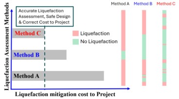
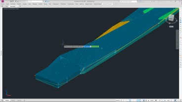
Advanced Techniques with 3D FEA and Satellite Remote Sensing (InSAR) Integration Case Study
- Mar, 28, 2023
- Finite Element / Finite Difference Numerical & Constitutive Modeling Road Embankments Ground Improvement Geomatics Satellite-Based News On Projects / Industry News On Software
- Authored by: Geoengineer.org
This case study demonstrates how Finite Element Method (FEM) analyses, combined with InSAR remote sensing monitoring, helped to complete an embankment project on soft ground and peat, safely and cost...
Read More
NASA maps landslides in central America caused by hurricane Eta
- Nov, 10, 2020
- Landslides Satellite-Based News On Research / Academia
- Central America
- Authored by: Geoengineer.org
NASA is currently mapping the landslides that were triggered during the passage of Hurricane Eta through Central America. Hurricane Eta struck in early November 2020 and was one of the most powerful...
Read More
ARIA Provides New Look of Earth's Surface from Nepal Quake
- May, 06, 2015
- News On Natural Disasters / Failures Satellite-Based Earthquake Reconnaissance
- Nepal
- Authored by: Geoengineer.org
It was only a minute the duration of the earthquake of Nepal, but this minute was enough to deform the Earth's surface as we used to know! The Advanced Rapid Imaging and Analysis project (ARIA) ena...
Read More
Satelite data reveal Calaveras fault's creep
- Dec, 25, 2014
- News On Projects / Industry Satellite-Based
- San Francisco, California, USA
- Authored by: Geoengineer.org
Satellite data of the last to decades, helped in mapping the land creep along the Calaveras and the Hayward faults east of the San Fransisco Bay, enabling scientists to reconstruct the underground geo...
Read More