When a major part of your infrastructure project lies over a long stretch of peatland, various preconstruction challenges may need to be overcome because of high compressibility, low bearing capacity of peat or excessive settlement obstacles. These factors need to be considered to avoid flooding, subsidence and other short- and long-term post construction failures. While the Réseau Électrique Métropolitain (REM) project in Montreal, Canada had to overcome several challenges associated with constructing embankments over soft and liquefiable soil, this case study focuses on how outcomes from settlement analysis using Settle3 was used in part to resolve the challenges associated with building infrastructure on peatlands.
Project overview
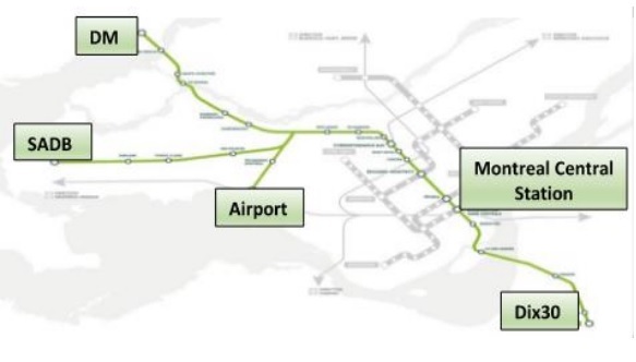
The Réseau Électrique Métropolitain (REM) is a 67 km fully automated light-rail-transit system proposed to cater to major metropolitan areas in Montreal, Canada. (Figure 1)
Figure 1: REM Project alignment
The project spreads out over 4 primary segments:
The 15km South Shore (SS) segment branching out of the downtown central station to Dix30 Commercial sector. A rail deck would be built to cross the St. Lawrence River.
The Deux Montagnes (DM) segment will consist of a direct conversion of the existing Deux Montagne’s line
The SADB segment will be an elevated structure supported by two abutments and 340 piers
The airport segment will make a slight diversion from the SADB line to terminate at Montréal–Pierre Elliott Trudeau International Airport.
Construction over peatland
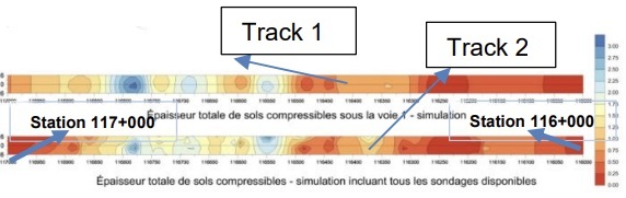
The Bois-de-Liesse sector, a large wetland of highly compressible organic clayey soils along the DM segment involved doubling, adjacent (proposed Track 2) to the existing Canadian National Railway line (Track 1).
Peat Thickness Distribution
New inspections and historical geotechnical data revealed the thickness of this layer varied from 0.3 to 0.6 m in the southern part to reach 2.0 to 3.3 m in the northern half of the area. Figure 2 shows the peat distribution along tracks 1 and 2 with dark red colour indicating the thickest area and dark blue, the thinnest.
Figure 2: Peat thickness distribution along Tracks 1 and 2
Peat Properties
Laboratory tests assessed the composition and properties of peat (Table 1). The water content ranged from 104 – 171% with 60% of organic material.
Table 1. Peat Properties
Soil Parameters
Track 1
Track 2
Cr (average recompression index)
0.1
0.2
Cc (average compression index)
0.5
1.5
Su (in situ shear strength), kPa
58 to 87
25
e (void ratio)
2.0
4.0
Em (elastic deformation modulus), MPa
1.1
1.1
γ (unit weight), kN/m³
12.4
12.4
Cα (secondary compression index)
0.025
0.01
Cv (coefficient of consolidation), m2/s
3.1E-07
4.4E-07
Analysis of the peat distribution and its properties suggested building the new Track 2 on the west side of Track 1 with a fill height of 3 to 5m.
Several potential soil improvement strategies were proposed to deal with construction over the peat stretch; and preloading was the chosen solution from a monetary and scheduling perspective of the project. In this light, SLOPE/W was used to run a limit equilibrium analysis to determine the maximum height of the embankment that could be built on highly compressible soils without risking a shear failure.
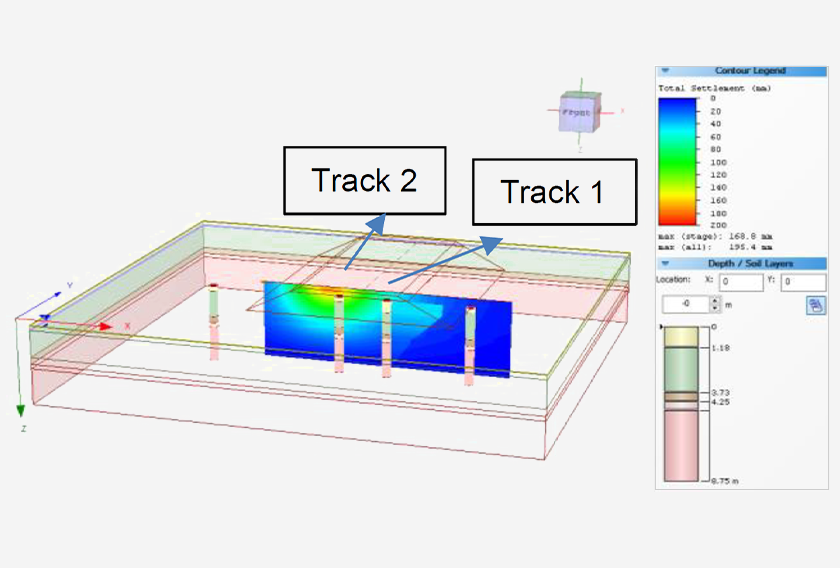
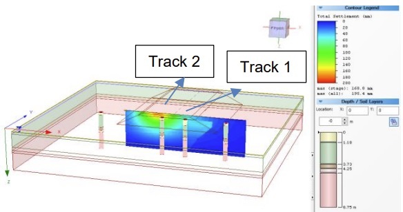
Settlement Analysis of Peatland using Settle3
While slope stability analysis was performed to ensure a minimum factor of safety of 1.5 against a rotational slip, Settle3 was used for the assessment of settlements. The settlement distribution underneath Track 1 and 2 is shown in Figure 3:
Figure 3. Typical settlement distribution under the tracks
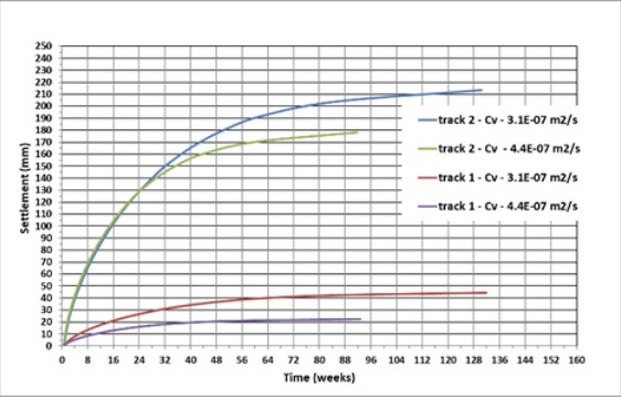
With an embankment height of 4m over the critical section (where peat thickness is 3m), the rate of settlement in weeks underneath both tracks are depicted in Figure 6 below:
Figure 4. Time rate settlement underneath the tracksResults of Settlement Analysis with Settle3
The first six months would see most of the settlement
Total consolidation settlement under Track 1 = 30mm
Total consolidation settlement under Track 2 = 200mm
Secondary settlement would occur at a rate of 5-10mm/year for 30 years, thereby reaching 175 -200mm
Settlement Monitoring
The magnitude and time span of settlement were considered acceptable. Settlement monitoring showed slightly different results than the estimated theoretical settlement, but the difference is within reasonable range. These differences could be explained by the difficulties in estimating the pre consolidation parameters from consolidation curves that showed signs of soil disturbance.
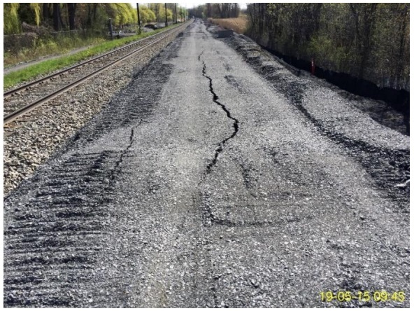
Figure 5. Crack appearance during construction
Longitudinal cracks (Figure 5) along the proposed Track 2, where the embankment height was 3m were in line with the observed differences. An examination by the REM geotechnical team concluded that the cracks were a result of differential settlement, not rotational slip or shear failure. The layer of peat under the existing Track 1 had consolidated and compacted over the several years of operation whereas the layers below Track 2 were still weak due to absence of consolidation.
These discrepancies were rectified by leveling the failure area to the planned elevation and compacting it. Additionally, a berm was constructed to avoid any further movement as a precautionary measure.
Conclusion
Numerous unanticipated yet notable challenges were encountered during design for the REM project in Montreal. This article primarily focused on the application of the software Settle3 in the settlement analysis of the peatland on which the project alignment was based, while briefly outlining other geotechnical obstacles. Berm construction and preloading being the solutions of choice, it was inferred that a combination of settlement analysis and monitoring captured the consolidation behavior of the wetland suggesting that they could be used in conjunction while considering construction on a peatland.
Geoengineer.org uses third party cookies to improve our website and your experience when using it. To find out more about the cookies we use and how to delete them visit our Cookies page. Allow cookies