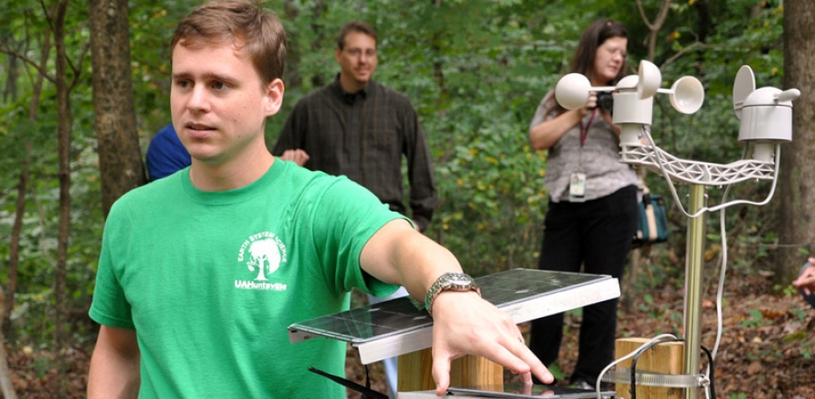
A team from the Atmospheric Science Department at the University of Alabama in Huntsville tested wireless sensors in an active landslide zone. The goal of the study was to estimate the potential information that these sensors can provide concerning the probability of a possible landslide.
These instruments are low cost and they utilize technology found in cell phones, robotics or irrigation systems, such as motion detectors and sensors which inform the user when the soil is saturated. Eric Anderson, a research associate in UAH's Earth System Science Center, who first came up with the concept, was inspired by the use of similar sensors in airborne instruments that measured soil moisture. The sensors have been also used for flood monitoring and warnings by the NASA/USRA team.
Source: UAH
Want to read more like this story?

Road safety improvement with the aid of smart geotechnical sensors
Mar, 14, 2022 | NewsGeotechnical sensors that will monitor the condition of Australia’s coastal roadways are developed...

Real time warning system for landslides
Aug, 09, 2018 | NewsA state-of-the-art system that is capable of warning people before landslides occur will be installe...
Landslides
Oct, 31, 2019 | Education
Can satellites be used as an early warning system for landslides?
Aug, 04, 2017 | NewsA joint team of researchers from Newcastle University (UK), Chengdu University of Technology, Tongji...

Measurand: Is SAA really different from other inclinometer systems?
Feb, 03, 2016 | NewsMeasurand has been helping geotechnical people solve their slope and structure monitoring problems f...

NASA maps landslides in central America caused by hurricane Eta
Nov, 10, 2020 | NewsNASA is currently mapping the landslides that were triggered during the passage of Hurricane Eta th...

Earthquake monitoring network established using submarine communication cables
Feb, 07, 2020 | NewsResearches have managed to create a submarine seismic network by utilizing communications lines est...

Citizen scientists at NASA’s service, for the creation of the largest landslide database
May, 24, 2018 | NewsThe aim is to get a better understanding of landslides with every report made Landslides ca...

New early warning system could have saved lives during the 2011 Japan tsunami
May, 28, 2017 | NewsSimulations assessing how the system would have responded to the 2011 Tohoku earthquake show that a...
On This Day
July 15th 2014
READ MORE
Trending

China's Three Gorges Dam under pressure: Flood hazard downstream

Functional requirements of foundation structures


Landslide in Papua New Guinea: At least 12 people dead


Major wastewater tunnel procurement begins in southern Sweden