Cracks Before Collapse: What the Söke–Kuşadası Highway Failure Reinforces About Slope and Wall Design

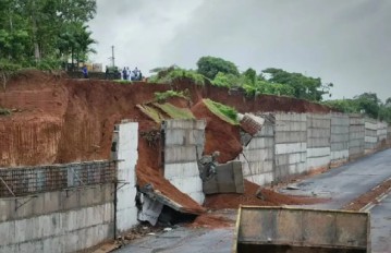
On 10 August 2025 a roadway collapse occurred on the Söke–Kuşadası corridor near Yaylaköy in southwestern Türkiye. Field checks against historical satellite imagery and roadside street views show longitudinal cracking along the carriageway at different dates, later sealed with mastic, and localized bending of guardrails that aligned with the crack trace. Regional screening on the national geoscience portal indicates mapped active landslides to the north and south of the failure zone and creep type ground movements to the west. These observations point to a slope system that had been signaling distress well before loss of ground. The pattern mirrors a 2021 incident on the Düzce–Zonguldak highway where intense rainfall preceded cracking, progressive deformation, and the collapse of two lanes documented by drone video.

Previous research on the Düzce–Zonguldak case evaluated a mechanically stabilized earth wall that had served for years before collapse. The study compared literature guidance with site observations and concluded that the dominant sequence was an external stability problem followed by overall stability loss. The trigger chain began with tensile cracking on the pavement, infiltration through the crack, strength reduction in foundation soils and within the reinforced zone, and a rise in hydrostatic forces that were not fully treated in the original assumptions. The analysis emphasized two recurring determinants of performance. The first is the engineering quality of the selected backfill, including fines content and electrochemical compatibility. The second is drainage, where rapid removal of surface and subsurface water is essential because many platforms are detailed without relying on hydrostatic pressures in design.
Transferred to Yaylaköy, the combined evidence of mapped mass movements, chronic surface cracking, and deformation of safety barriers is consistent with a progressive reduction in stability under seasonal rainfall. In such settings, investigations should verify groundwater regime, confirm backfill gradation limits, trace potential preferential flow paths, and check that internal and behind the wall drains are continuous, accessible, and functional.
Experience from both corridors underscores the value of low cost surveillance. Periodic review of satellite scenes and street level imagery can flag changes years in advance. For new or rehabilitated sections, early service life instrumentation and visual inspections during the first wet season provide disproportionate benefit. Where risk is elevated, agencies can prioritize pavement crack sealing with drainage control, install relief measures at the wall toe, and adjust maintenance to keep collector ditches and outlets clear. The consistent message remains simple. Good fill and good drainage reduce uncertainty, while early detection turns small repairs into avoided collapses.
Below is a drone video capturing the major collapse that occurred on the Düzce–Zonguldak highway in 2021. Check also, the LinkedIn post and research study for additional information.

Sources: linkedin.com/in/tahir-y, 9geoteknik.org, businessturkeytoday.com
Want to read more like this story?
Heavy rain triggers retaining wall collapse at highway construction site in Karnataka
Jul, 02, 2026 | NewsA retaining wall and part of a hillside collapsed at an under-construction National Highway site nea...
Pore Pressure and Retaining Wall Drainage
Feb, 06, 2026 | EducationThe Critical Role of Groundwater Water is the single most destructive element in retaining wall st...

Landslide collapses hotel and shops along Jammu-Srinagar highway
Oct, 12, 2025 | NewsA substantial landslide along the Jammu–Srinagar National Highway (NH-44) caused the collapse of a...
Classification and Mechanics of Retaining Structures
Feb, 06, 2026 | EducationThe Function of Retaining Walls A retaining wall is defined as a structure whose primary funct...
Levels of Analysis Used in Retaining Wall Design
Feb, 06, 2026 | EducationThe analysis of retaining structures is commonly approached in three progressively more advanced le...

Retaining wall collapses onto cars in Vladivostok
Aug, 24, 2024 | NewsSeveral videos have recently emerged, showing a retaining wall collapsing onto parked cars in the...
Sheet Pile Wall Design
Feb, 06, 2026 | EducationA sheet pile wall is a line of interlocking thin wall elements driven into the ground to form a...

Deep cement mixing linked to deadly quick clay failure in Norway
Mar, 18, 2026 | NewsA fatal landslide that occurred during a railway expansion project in Levanger, Norway, has been li...
Five-Storey Building Fails Amidst Road Construction in Himachal
Jun, 30, 2025 | NewsA five-storey building in Shimla's Bhattakufar area collapsed on June 30, 2025, following a prolong...
On This Day
July 7th 2012
READ MORE
Related Video

Trending

Life after gINT - Rethinking geotechnical data management for a new era

Is Africa gradually splitting into two sections?

Stop Guessing, Start Designing: Introducing Support Designer in Slide2


Alert level is raised in Mexico as the Popocatépetl volcano spews ash and gas
Emergency ground stabilisation protects rail works near Salford Central