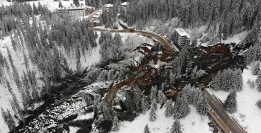
Bogoslof island has tripled in size after volcano’s continuing eruptions

Bogoslof volcano is in an active eruption sequence since December 12, 2016. The series of short-duration explosive events - more than 27 of them up until now - has led to significant changes in the island's morphology.
The volcano is located about 60 miles west of Dutch Harbor, in Alaska's Aleutian Islands. It's not considered as a highly active volcano, since only 8 eruptive events have been recorded since 1796, with the last one occurring in 1992.
Recent satellite images provided by the Alaska Volcano Observatory (AVO) indicate that the freshly erupted volcanic rock pieces and tephra have totally changed the shape and coastline of the island. On January 31, Bogoslof Island had an area of about 1 square kilometer, thus three times larger than it was when the eruptions started in December.
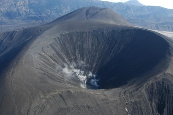
Based of previously recorded eruptions, scientists of the AVO expect that the explosions may continue for weeks or more. They continuously monitor the volcano from a series of seismic networks in the Aleutians and believe that it is likely for the current eruption sequence to follow the pattern of other historical eruptions; eventually a lava dome may be extruded at the surface, they state.
The new land that has been created during the past months consists of tephra, thus it is very susceptible to erosion from wave action. According to the AVO scientists, continued volcanic activity along with wave erosion will most probably modify the island further in the next weeks.
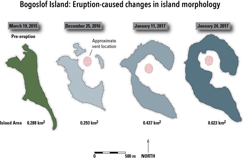 Image Source: Alaska Volcano Observatory / U.S. Geological Survey.
Sources: Alaska Volcano Observatory, adn.com
Want to read more like this story?

New Zealand volcano eruption: At least 5 dead
Dec, 09, 2019 | NewsAt least 5 people were reported dead after a volcano erupted in New Zealand's White Island on Monda...

Tongan volcano activity forms island in the Pacific [Video]
Jan, 23, 2015 | NewsA new island is being formed in the Pacific Ocean as a result of volcanic eruption. The volcanic act...

New island off Japan can be seen forming from underwater volcanic eruption
Oct, 21, 2023 | NewsA new island can be seen being created from an underwater volcano erupting off the coast of Japan,...
New volcanic eruption prediction model
Sep, 18, 2019 | NewsResearchers from the University of Illinois and the University of Michigan have developed a new tec...

The Future of Volcanology: AI and Machine Learning Take the Lead
Mar, 10, 2025 | NewsPredicting volcanic eruptions has always been a challenge due to the unpredictable nature of volcan...
Indonesian volcano potential eruption: People evacuated from nearby regions
Nov, 05, 2020 | NewsNumerous people have been evacuated from regions near Mount Merapi in Indonesia after fears of a po...

Increasing seismic activity recorded under San Miguel volcano, El Salvador
Apr, 19, 2017 | NewsIn a report released on April 18, 2017, the country's Ministry of Environment and Natural Resources...

New findings on large volcanic eruptions
Jan, 04, 2021 | NewsScientists have developed new numerical models that efficiently reconstruct eruptions from large vo...

Tsunami hits South Pacific island of Tonga following a giant volcanic eruption: streets and buildings flooded
Jan, 15, 2022 | NewsTonga's largest island, Tongatapu, has been hit by a tsunami when an underwater volcano in the Sout...
On This Day

Related Video

Trending
Active landslide threatens long-term connectivity in southern Bulgaria


PLAXIS example: Westergaard's added mass for hydrodynamic pressures

Rock Mass Classification Systems: A Global Review of Use and Dominant Approaches
How does the Leaning Tower of Pisa survive earthquakes

Emergency ground stabilisation protects rail works near Salford Central