Study on the East African Rift System: Madagascar will split into pieces
According to a new study on the kinematics of the East African Rift System, much of the continental regions are currently splitting with Madagascar being gradually separated into pieces.
East African Rift System is a complex continental rift zone that emerged about 22-25 million years ago. The tectonic regime includes tectonic forces that split apart plates to create new ones in a geologic process that has not been fully understood yet.
The most studied and oldest rifts are located in Ethiopia while a series of rifts extend west and consists of many branches. The entire system extends for more than 1000 kilometers and reaches the red sea and the Gulf of Aden between Yemen and Somalia.
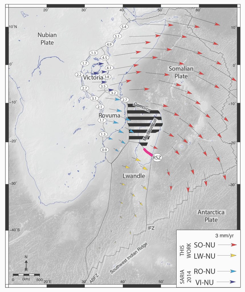
According to a new study, published in the journal Geology in September 2020, the splitting phase began around 200 million years ago and will radically change the continental and the oceanic landscape in the future. Regarding Madagascar, it is expected to be split into smaller islands. In particular, the south part of the island will deform with a tectonic block known as the Lwandle microplate while central Madagascar will move along with the Somalian plate. The rest of the island will flexibly adjust to the deformations imposed.
Nevertheless, these drastic changes will not occur soon, in terms of time as people perceive it. The plates' displacements occur at a rate of some millimeters annually, therefore it will require millions of years before the changes are apparent. What is certain is that the north parts of the system move faster and thus, new oceans will initially emerge.
Preceding surveys suggest that the system consists of narrow zones in microplates that experience extension and deform separately from the major tectonic plates. The research team collected data from seismic stations situated in Madagascar, Eastern Africa and in other islands to derive the characteristics of the complex rift system. They found that the splitting procedure is far more complicated than previously thought.
In particular, the team found an extension zone that ranges between East Africa and Madagascar with its length being around 600 kilometers. Moreover, by conducting a detailed statistical analysis the researchers re-evaluated the boundaries between the Somalian plate and the Lwandle microplate. “Accurately defining plate boundaries and assessing if continents diverge along narrowly deforming zones or through wide zones of diffuse deformation is crucial to unraveling the nature of continental break-up. In this work, we have redefined how the world’s largest continental rift is extending using a new GPS velocity solution,” D. Stamps, lead author of the study and an Assistant Professor in the Virginia Tech College of Science, stated.
The study has also aided in understanding earthquake and volcanic activity in the vicinity of the East African Rift System that would be otherwise not been adequately explained. The authors suggest that the developed method will be used in future investigations to derive complex tectonic plate movements.
Source: VirginiaTech
Want to read more like this story?

Is Africa gradually splitting into two sections?
Jun, 21, 2018 | NewsAfter a huge crack made an appearance in the south-western Kenya, the question that lies is whether...

New study on tectonic plates movements reveals potential regions with less seismic activity
Jun, 27, 2020 | NewsA new study sheds light on regions where earthquake activity is less likely to occur. Researchers f...
Finding a missing tectonic plate
Oct, 19, 2020 | NewsScientists from the University of Houston have managed to detect signs of a controversial tectonic...

Massive earthquakes possibly associated with tectonic plates reversal
Apr, 29, 2020 | NewsResearchers have found that there is a possible connection between large seismic shocks and the rev...

Deep Rift Beneath the Himalayas: Indian Plate Splitting and the Implications
Jul, 23, 2025 | NewsA major geophysical study unveiled at the AGU conference has confirmed that the Indian Plate is und...

New scenario about the formation of Central Alps
Aug, 25, 2020 | NewsScientists at ETH Zurich have developed a new model that simulates the development of the central A...

The mystery behind east Australia's volcanoes
Dec, 16, 2020 | NewsScientists have shed light on the existence of so many volcanoes across a belt in Australia. The ea...

Researchers Develop Theory Behind New Madrid Earthquakes
Sep, 22, 2016 | NewsResearchers along with USGS believe they may have developed a theory to explain the mid-plate earthq...
Ethiopia's geothermal energy monitored and mapped
Apr, 28, 2015 | NewsAluto volcano, Ethiopia's main source of geothermal energy is in the center of attention, for a grou...
On This Day
July 21st 1952
READ MORE
Trending

Life after gINT - Rethinking geotechnical data management for a new era

Stop Guessing, Start Designing: Introducing Support Designer in Slide2


Alert level is raised in Mexico as the Popocatépetl volcano spews ash and gas

Embankment Collapse on NH-66 in Kooriyad Triggers Engineering and Oversight Review

Major wastewater tunnel procurement begins in southern Sweden