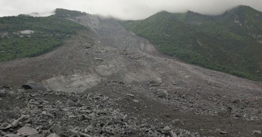
Peatlands are more than just soft, soggy ground. In Scotland, they cover vast, remote, and ecologically significant areas—and they are increasingly the focus of environmental restoration efforts. But peat isn’t just passive landscape. It moves, it flexes, and sometimes, it fails catastrophically. Landslides, bog bursts, and peat flows can devastate ecosystems, destroy infrastructure, and derail costly restoration initiatives.
That’s where space-borne technology enters the scene. A groundbreaking previous study by
Mills and Rushton (2023) and a recent by
et.al Large, D.J. (2025), in collaboration with
NatureScot, used time-series data from Interferometric Synthetic Aperture Radar (InSAR) to track how the surface of peatlands shifts in response to changes in water content over time. These subtle vertical movements—barely a few centimeters—are more than just natural breathing. When exaggerated, they can signal hidden instability.
The logic is simple but powerful: where peat expands and contracts significantly due to water storage changes, there’s a higher chance it could fail. The InSAR technique doesn’t replace boots-on-the-ground investigation, but it flags the danger zones early—potentially years before a landslide happens. That kind of foresight could save millions in damage, restoration, and mitigation.
Science in Motion: From Radar to Risk Maps
Using data from 2018 to 2021, the team analyzed 20 peatland sites across Scotland—including Auchlyne, Blairadam, Dalmellington Moss, and many more. These sites were chosen not just for their restoration potential but because independent landslide susceptibility assessments had already been carried out. This made them ideal testbeds.
The InSAR data, processed using the APSIS method, provided 20-meter resolution vertical surface motion records. Think of it as taking a pulse of the landscape every few days for four years. The researchers then calculated the difference between maximum and minimum surface motion—an indicator they call the Range of Vertical Surface Motion (RVSM). This RVSM was categorized into five percentile classes: negligible, low, moderate, high, and very high.
One striking revelation was that areas exceeding the 95th percentile in RVSM—places where the ground moved the most vertically—often aligned with previous landslides or were situated along drainage lines. These zones, even when visually unremarkable, hold a ticking geotechnical time bomb.
Sites like Delnadamph and Mossband Wood showcased how surface motion patterns could be linked to both natural topography and human interventions like drainage or restoration. At Mossband Wood, a known landslide in 2018 aligned with an area of persistent high RVSM. In contrast, places like Greenhead Moss displayed minimal surface motion and were deemed low-risk.
Crucially, even relatively small zones of high RVSM were often significant. For example, in the Irish case studies referenced from 2020, the exact points of landslide initiation coincided with high RVSM zones—detectable as early as two years before the failure. This lends serious credibility to the technique as a predictive screening tool.
Toward Smarter Restoration and Monitoring
The implications of this research are far-reaching. For one, it offers restoration practitioners an efficient way to triage where to send geotechnical teams. It doesn’t eliminate the need for detailed site analysis—but it narrows the field. If you’re restoring a site with thousands of hectares of blanket bog, InSAR can tell you which 5% to prioritize.
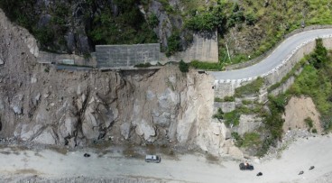
It also has potential beyond restoration. Forestry operations, wind farm developments, and infrastructure planning can all benefit from early detection of peat instability. This includes road construction near sites like Dalmellington Moss, where high RVSM patterns align closely with adjacent infrastructure.
Importantly, surface motion data could even serve as a post-restoration diagnostic. Did that drain-blocking intervention stabilize the site—or destabilize it? InSAR provides the answer without setting foot on the bog.
While the method is promising, researchers stress it’s not foolproof. High RVSM doesn’t guarantee a slide—it only raises the likelihood. Likewise, low RVSM isn’t a guarantee of safety. Variables like peat thickness, internal structure, and slope geometry still matter. That’s why integration with traditional geotechnical studies is essential.
Future development of this methodology may even include warning systems. Could machine learning applied to InSAR time series predict failure windows? Could extreme value theory flag when peat movement trends shift from benign to dangerous? The possibilities are as exciting as they are essential in our climate-uncertain future.
NatureScot is now considering whether to embed InSAR analysis into its standard protocol for assessing landslide risk on peatlands before and after restoration. If adopted, it would represent a major step forward in the sustainable management of Scotland’s peat-rich landscapes.
Read the full article
here.