More than 50% of U.S. infrastructure threatened by natural hazards

According to a new study from the University of Colorado, Boulder, about 57% of infrastructure established in the United States is threatened by natural hazards.
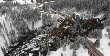
Despite significant advances in infrastructure development and resilience have been made through the years, natural hazards remain a potential threat that can cause severe damage or complete destruction. Technology has made possible the prediction of such phenomena and the establishment of warning systems to alert people but, ultimately, infrastructure exposed to natural hazards will inevitably be impacted.
The authors of the study created hazard maps of natural disasters (earthquakes, hurricanes, tornadoes, floods and wildfires) and identified hotspots in which the probability of one disaster is more than 10%. In fact, these hotspots account for 1/3 of the total land in the U.S. Then, the team compared the generated maps with available property and housing data. “Vulnerability matters. There’s evidence that natural disasters exacerbate socioeconomic inequality,” V. Iglesias, lead author of the study and a research scientist with the University of Colorado Boulder Earth Lab, stated.
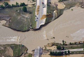
The findings suggest that 57% of the infrastructure in the U.S. (a total sum of 1.5 million structures) is located in the aforementioned hotspots. In addition, despite building rates have been reduced over the last years, structures found in the hotspots are increasing. Historically, the most impactful natural disasters have occurred within these hotspots. The Galveston hurricane in Texas and Oklahoma (1900) destroyed more than 3,600 buildings and caused between 6,000 and 12,000 fatalities. The San Francisco earthquake in 1906 resulted in more than 3,000 casualties and in $11 billion financial loss (inflation-adjusted). The incident is one of the deadliest ever recorded in the U.S. as more than 80% of the San Francisco was destroyed. The Tri-State Tornado, one of the worst tornadoes in history hit eastern Missouri, southern Illinois, and southern Indiana killing 629 people and causing a $2.3 billion loss (inflation-adjusted). In addition, recent extreme events (e.g., Hurricane Katrina, Superstorm Sandy etc.) confirm the tendency of such disasters to occur within these specified areas.
The study suggests that there are 2 main causes for the current, unfavorable conditions. The first is associated with climate change that has proved to aggravate the intensity and magnitude of natural hazards. However, the second cause is the improvident infrastructure development in regions that are prone to natural disasters. In particular, building new structures in the developed urban regions increase the hazard posed by hurricanes and earthquakes while new facilities in rural regions are more prone to floods, tornadoes and wildfires.
The team emphasizes the need to incorporate the findings of this study on the risk assessment of future infrastructure development. Clearly, the avoidance of establishing buildings in hotspots will also be financially beneficial since fewer funds on repairing destroyed infrastructure will be dedicated.
Sources: Iglesias et al. (2021), AGU
Image Gallery

Want to read more like this story?

Risk assessment on natural disasters in densely populated Himalayan regions
Sep, 18, 2021 | NewsA new study focuses on the multi-hazard susceptibility of a densely populated region in the Himalay...

Remote sensing of natural hazards (ORISAT)
Jul, 11, 2023 | EventVolcanoes, glaciers, landslides, faults: these are all natural objects that can pose a major risk to...

45% of Himachal Pradesh at Risk of Landslides and Floods – What Can Be Done?
Feb, 19, 2025 | NewsA recent geospatial study has revealed that over 45% of Himachal Pradesh is highly susceptible to l...
Reconnaissance of Natural Disasters
May, 13, 2020 | Education

Risk assessment of rainfall-induced landslides in urban regions
Aug, 09, 2021 | NewsA new study suggests that urban areas are more prone to rainfall-induced landslides compared to rur...

"SimCenter Tools to Support Natural Hazards Research: From Local to Regional Scale", part of "The future of Infrastructure today!" webinar series
Mar, 27, 2024 | EventLecture date: Friday April 19, 9:00-10:00AM PST "The future of Infrastructure today!” is a monthly...

Study suggests that smaller earthquakes generate most strong ground motions
Jan, 04, 2021 | NewsAccording to a new study, smaller earthquakes have caused the strongest shaking incidents in the vi...
How can twitter help engineers assess infrastructure performance: the Colorado floods case
Sep, 04, 2014 | NewsLast year's massive flooding in Colorado's Front Range affected a widespread area, destroyed roads a...

NASA maps landslides in central America caused by hurricane Eta
Nov, 10, 2020 | NewsNASA is currently mapping the landslides that were triggered during the passage of Hurricane Eta th...
On This Day
July 19th 1985
READ MORE
Related Video

Trending
Active landslide threatens long-term connectivity in southern Bulgaria


PLAXIS example: Westergaard's added mass for hydrodynamic pressures

Rock Mass Classification Systems: A Global Review of Use and Dominant Approaches

How does the Leaning Tower of Pisa survive earthquakes
Major wastewater tunnel procurement begins in southern Sweden