GEER responds to the 2015 Kfarnabrakh rockslide, based on the message by Professor Chadi El Mohtar.
Dear Geotech Colleagues,
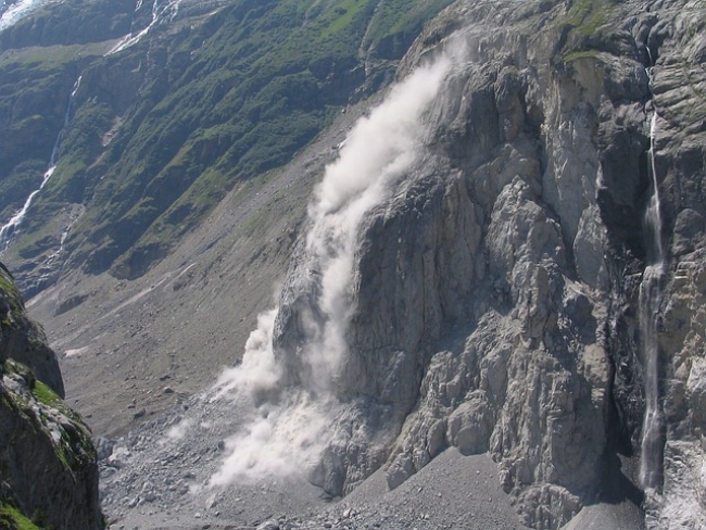
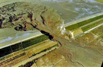
During the early hours of November 30th, 2015, the mountain town of Kfarnabrakh experienced a major landslide at one of the town’s rock cliffs. Kfarnabrakh is 1,150 meters above the sea level, 45 km south-east of Beirut, and about 30 km away from the Mediterranean seacoast. The landslide was well documented with multiple cellphone videos captured by the local residents (check link at the end of this email) that were later used to finalize the failure mechanism. The rock cliffs are located at the north-northeast edge of the village with houses constructed within few meters of the cliff edges. Seventeen houses were evacuated and the families were provided temporary housing until the stability and safety of the sliding zone is assessed.
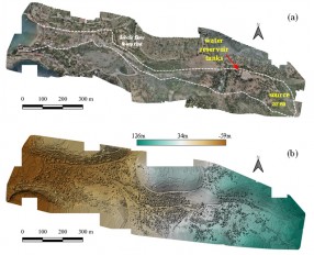
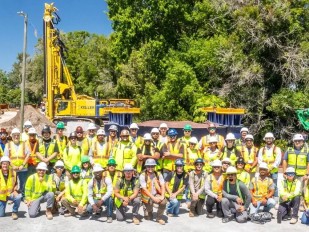
In response to this extreme event, a recon team sponsored by the NSF-sponsored Geotechnical Extreme Events Reconnaissance (GEER) Association and the Lebanese National Council for Scientific Research (NCSR-L) authorities, had multiple visits to the location of the landslide and collected information from the local residents on the events of the day of the failure. In addition, the team explored the area and checked for possible locations of future breakoffs. A drone was used for aerial photography acquisition and a Digital Surface Model was generated for the area of interest. Geologic and hydrogeological maps of the area were used to help understand the cause of failure. Rainfall and seismic records didn’t show any major events in the days leading to the failure. The failure occurred in the C3 formation, a highly jointed chalky limestone. The C3 formation has an embedded thin layer (about 0.3-0.5m thick) of high plasticity Blue Marl clay located 20-25 m. from the top of the formation.
The GEER report is available at: http://www.geerassociation.org/component/geer_reports/?view=geerreports&id=74&layout=default
The YouTube video of the landslide occurring can be seen at: https://www.youtube.com/watch?v=1qTtrICtT-A&feature=youtu.be
A YouTube video of the area generated from the drone images can be seen at: https://www.youtube.com/watch?v=MPZiwozwMOs
We invite you all to take a look. Chadi El Mohtar, Grace Abou-Jaoude, Chadi Abdallah and Jacques Harb.
The news item is based on the message by Professor Chadi El Mohtar
Want to read more like this story?

Central Texas Floods-May 23-25, 2015
Jun, 15, 2015 | NewsSignificant rainfall moved across Central Texas over Memorial Day Weekend, May 23-25, 2015, causing...
GEER Report for Medicane Ianos Released: Documents thousands of landslides, bridge collapses and infrastructure damage
Dec, 17, 2020 | NewsThe Geotechnical Extreme Events Reconnaissance (GEER) released a report documenting damage...

Cracks open in South England's cliff indicating a potential collapse
Sep, 06, 2020 | NewsThick cracks that emerged on the top of a cliff in South England indicate a potential cliff collaps...

Massive cliff collapse in Jurassic Coast, UK
Apr, 12, 2021 | NewsA cliff collapse that occurred in England's Jurassic Coast is considered to be the largest to hit t...

A large landslide struck a town in New York State: 3 residences evacuated
May, 03, 2020 | NewsFour houses accommodating 12 people have been evacuated after a large landslide struck in the town...

English coastal town’s households evacuated after landslide
Nov, 15, 2023 | NewsA landslide in the English coastal town of St Leonards-on-Sea led to several cliff top properties b...
Video: NASA generated landslide map reveals most landslide prone areas!
Apr, 22, 2015 | NewsRain-induced landslides have hit a death toll of nearly 20,000 since 2007. For an overview of the la...
Landslides
Oct, 31, 2019 | Education

Massive landslip blocks Seatown Beach in Dorset, UK
Jul, 20, 2023 | NewsA massive rockfall occurred on the cliffs of Seatown in Dorset, UK, overnight on Thursday. Further...
On This Day

Related Video

Trending

Tiebacks vs. soil nails: Choosing the right earth retention solution
When Dams Fail: The Growing Crisis of Tailings Management
Mexico City’s sinking crisis mapped by next-generation satellite
Landslide in Northern Peru Forces Evacuation of Over 170 Residents
Sinkhole outside home in Huntington Station, on Long Island: 3 fall into

Stop Guessing, Start Designing: Introducing Support Designer in Slide2
Development program prepares new engineers for success