Washington employs LiDAR technology against landslide risk
Washington's Department of Natural Resources (DNR) is making use of the best technology available to collect, analyze, and publicly distribute detailed information about the state's geology, through a new lidar database with special focus on landslides hazard.
Lacking adequate maps to show landslide risk, Washington State decided to commit a 36$ million piece of its budget through 2021, towards this direction. A new lidar program has been set up and the goal is to gather high-quality lidar data for the whole state.
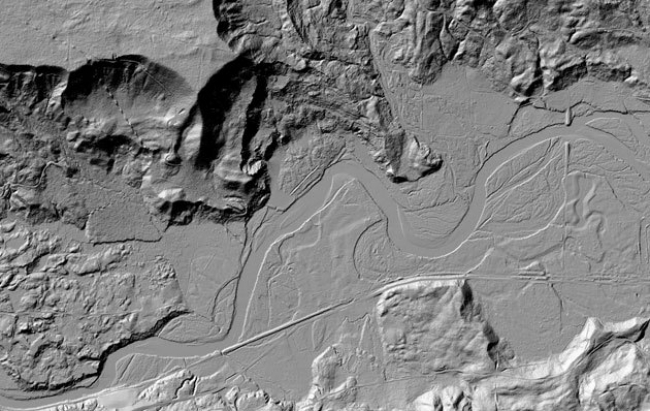
Lidar (Light Detection and Ranging) technology employs special lasers mounted on aircrafts to map topography by measuring reflected light. Maps generated by lidar provide an extremely accurate (to within a few inches) model of the existing topography, since the beams of light make it through obstacles like vegetation, to show the landscape below.
Washington's DNR Division of Geology and Earth Resources is already collecting, inventorying, processing and storing existing lidar data, while new airborne lidar collection is underway, starting from areas of high landslide risk, where population density is high and/or critical infrastructure exists. Up until now, high-quality lidar data for about 17,049 square miles have been collected, according to The Seattle Times; that's roughly 24% of the State. Many areas that already exist in landslide inventories but have poor quality coverage, will be remapped using lidar technology, in order to be of use in landslide hazard assessments. Washington's DHR is posting its maps online, at the state's lidar portal. The portal is a collection of lidar from DNR's inventory, projects from the Puget Sound Lidar Consortium, as well as data donated from counties and cities.
What is more, in March 2016, the Washington Geological Survey's Landslide Hazards Program (LHP) started a pilot project in Pierce County, Washington, using a newly developed streamlined landslide mapping protocol (SLIP) to create rapid landslide inventories from lidar. The method allows for rapid mapping of landslides from high-quality lidar and works as such:
- High-confidence landslides are mapped as individual polygons that include deposits, flanks, and scarp — the landslide-affected area.
- Lower-certainty landslides are identified as points and assigned an attribute of low or moderate confidence.
Avoiding the time-consuming process of populating tabular data (landslide type, landslide material, age, geology, etc.), geologists are able through SLIP Landslide Inventories to quickly share landslide data with stakeholders and decision-makers. The method can also assist in the prioritization of areas for future detailed landslide inventory and susceptibility mapping.
As stated in the Washington's DNR Project Summary, the LHP and Pierce County were able to focus on critical areas for detailed landslide mapping, by implementing the SLIP method. In areas where detailed mapping was unneeded, the SLIP landslide polygons will remain an effective tool for the county to identify mapped landslide hazards. You can read more about the SLIP Method in the Washington's DNR Project Summary.
Sources: The Seattle Times, Washington DNR
Nearby News
Want to read more like this story?
Landslides
Oct, 31, 2019 | Education

LiDAR technology: a new perspective in landslide risk evaluation
Apr, 10, 2014 | NewsOn the occasion of the Oso landslide, LiDAR technology comes forward, as an efficient means of revea...

About less deadly landslides!
Mar, 24, 2015 | NewsCould the Oso landslide have been avoided? Are there more landslide prone areas across the country a...
Arizona Geological Survey: New landslide inventory project about to begin
Apr, 09, 2015 | NewsAs a result of the continuing landslides and their detrimental effects on property and infrastructur...
Video: NASA generated landslide map reveals most landslide prone areas!
Apr, 22, 2015 | NewsRain-induced landslides have hit a death toll of nearly 20,000 since 2007. For an overview of the la...

Learning from Landslides
Jun, 10, 2015 | NewsThe Kentucky Geological Survey is compiling a landslide inventory database to document the distribut...

Citizen scientists at NASA’s service, for the creation of the largest landslide database
May, 24, 2018 | NewsThe aim is to get a better understanding of landslides with every report made Landslides ca...

Damage Assessment by Laser Could Focus Post-Earthquake Response
Feb, 08, 2018 | NewsAirborne lidar surveys taken before and after a powerful 2016 earthquake in Japan revealed the poten...

Urban areas at greater risk for landslides due to the effects of precipitation
Aug, 09, 2021 | NewsA new study indicates that urbanized areas are more prone to landslides caused by precipitation tha...
On This Day

Related Video

Trending
Active landslide threatens long-term connectivity in southern Bulgaria


PLAXIS example: Westergaard's added mass for hydrodynamic pressures

Rock Mass Classification Systems: A Global Review of Use and Dominant Approaches

How does the Leaning Tower of Pisa survive earthquakes
Nepal’s Himalayan settlements face escalating flood and landslide threats