Puerto Rico's terrain changed after a series of earthquakes hit the region
NASA is currently examining satellite imagery data to determine the landscape changes in Puerto Rico caused by a series of earthquakes.
Numerous seismic shocks (around 2,000) have recently struck Puerco Rico. The most powerful earthquake (M 6,4) occurred on January 7, 2020, and caused one casualty, damaged around 600 buildings and resulted in about $110 million financial loss.
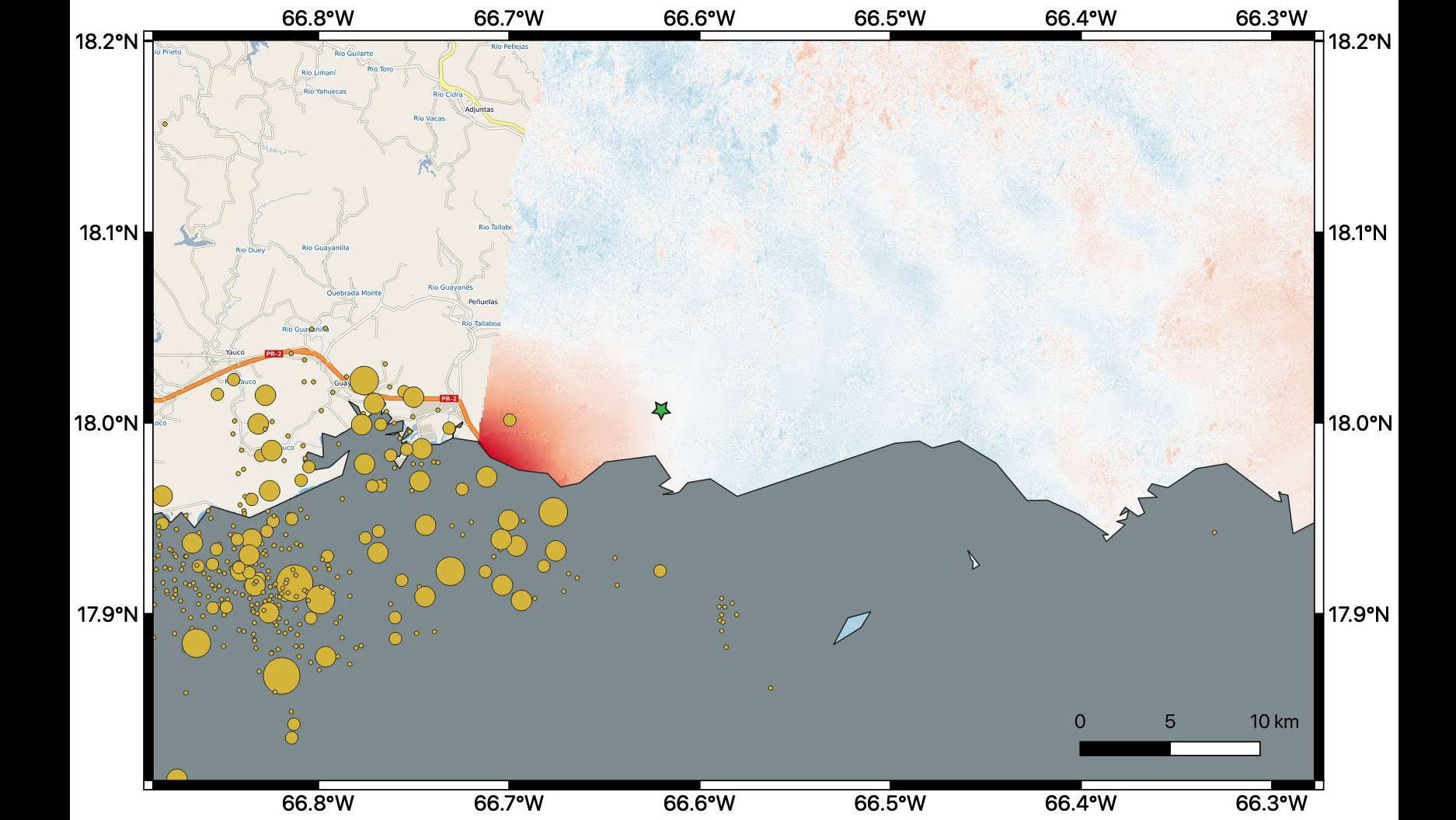
Those tremblors have caused permanent ground swifts in the landscape of Puerto Rico. Researches from NASA are thoroughly investigating data from Copernicus Sentinel-1A, a satellite handled by the European Space Agency (ESA), retrieved on December 28, 2019, and January 9, 2020, respectively, to quantify those alterations.
By analyzing the data, scientists discovered that the most significant landscape changes occurred in Ponce, a city located on the southern coast of Puerto Rico. The city is close to the M 6,4 earthquake epicenter. According to scientists, the ground has moved "downward and slightly to the west" and the maximum displacement measured was 14 centimeters.
The United States Geological Survey (USGS) has announced potential scenarios about the aftershocks sequence in Puerto Rico from January 18 to February 18, 2020. One of those possible scenarios will occur.
- Scenario 1 (79%)
The first scenario is the most likely to occur with 79% chances. In that case, the number and the magnitude of earthquakes will decrease in the aforementioned period. No earthquake similar to the M 6.4 that occurred on January 7 is anticipated but moderate shocks (> M 5.0) will possibly hit the region.
- Scenario 2 (18%)
According to scenario number 2, another earthquake similar to the M 6.4 incident will occur. This phenomenon is known as the "doublet" and describes a case in which 2 large seismic shocks occur very close in terms of time and location. A second earthquake would probably result in an increased number of aftershocks in the forthcoming period.
- Scenario 3 (3%)
The last scenario includes the occurrence of an earthquake larger than the M 6.4 shock but it is less likely to occur. In this case, a severe tremblor would strike Puerto Rico and would probably result in severe damage. Aftershock incidents would also increase.
NASA has not been able to analyze all of the affected region (as shown in the image above). The epicenter of the M 6.4 quake and the group of aftershocks that occurred were out of the reach of Copernicus Sentinel-1A on January, 9. Therefore, the Space Agency has collected additional data from the same satellite on January 14 which are currently analyzed.
Want to read more like this story?

Hundreds of earthquakes struck Puerto Rico within 10 days
Jan, 07, 2020 | NewsMore than 500 tremblors have struck Puerto Rico during a 10-day period. On December 28, 2019, a M 4...

Two powerful earthquakes hit China: Reports of 3 people dead
May, 21, 2021 | NewsTwo separate, strong earthquakes that struck in China have resulted in, at least, 3 fatalities. The...

The largest earthquake in 66 years struck Nevada
May, 15, 2020 | NewsA M 6.5 earthquake that hit on Friday, May 15, 2020 is the largest one to occur in Nevada since 195...

2 strong earthquake hit Philippines: At least 14 fatalities
Oct, 29, 2019 | NewsAt least 14 people died after 2 earthquakes struck the southern part of Philippines. The first seis...

Massive earthquake struck off the coast of New Zealand
Jun, 18, 2020 | NewsA M 7.4 earthquake struck off the coast of New Zealand raising concerns about a potential tsunami....

5.7-Magnitude earthquake hits Istanbul: 8 injuries reported
Sep, 26, 2019 | NewsA 5.7-magnitude earthquake struck near Istanbul, the largest city of Turkey with 15 million people....

Study suggests that smaller earthquakes generate most strong ground motions
Jan, 04, 2021 | NewsAccording to a new study, smaller earthquakes have caused the strongest shaking incidents in the vi...

Powerful earthquake struck Mexico: At least one fatality
Sep, 08, 2021 | NewsAt least one person died after a M 7.0 earthquake hit southwestern Mexico on September 8, 2021. Th...

M 6,0 seismic shock hits China causing at least 3 fatalities
Sep, 15, 2021 | NewsAt least 3 people have died after a M6.0 struck southwestern China. The seismic shock occurred on S...
On This Day
July 19th 1985
READ MORE
Trending
Active landslide threatens long-term connectivity in southern Bulgaria


PLAXIS example: Westergaard's added mass for hydrodynamic pressures

Rock Mass Classification Systems: A Global Review of Use and Dominant Approaches

How does the Leaning Tower of Pisa survive earthquakes

Tailrace tunnel breakthrough advances Australia’s largest renewable project

A Legacy of Leadership, Mentorship & Service: Gary L. Seider P.E.