Numerous landslides triggered after M7.2 earthquake in Haiti
Numerous landslides have been recorded in Haiti after a M7.2 earthquake struck in August 2021.
The M 7.2 earthquake struck Haiti on August 14, 2021, at 8:29 am local time causing massive infrastructure damage and more than 1,900 fatalities. The United States Geological Survey reported that more than 1 million people experienced very strong to severe shaking. More on the impact of the seismic shock can be found here.
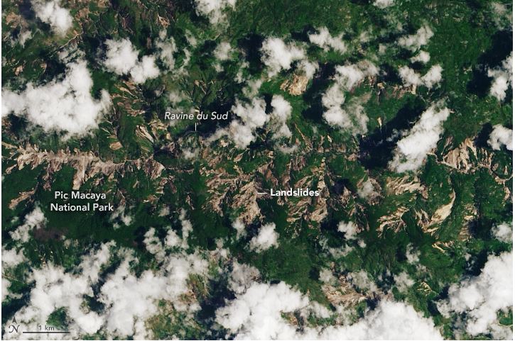
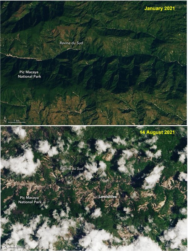
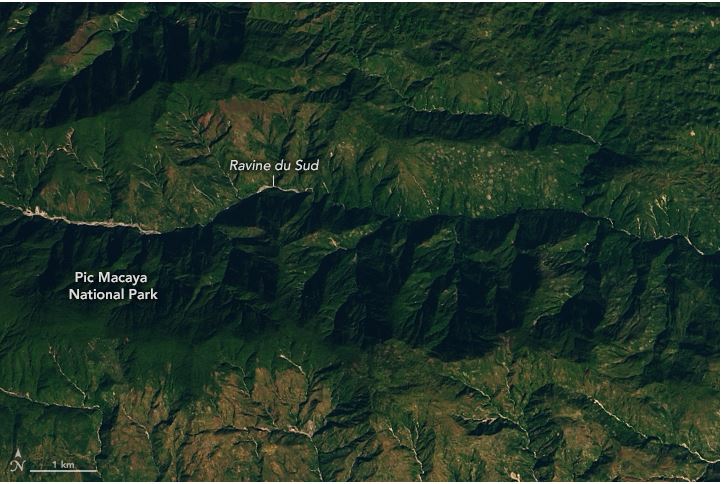
On the same day of the quake, NASA collected imagery from Landsat 8, a satellite that completes one orbit of the Earth every 99 minutes. The data showed the completely altered landscape of the Pic Macaya National Park in southwestern Haiti which was devastated by landslide incidents (see the figure below). As a comparison, an image of the mountaintops on January 2021 is also provided.
Additional ground failures occurred in the region as a result of tropical depression Grace. Emberson suggested that much of the mobilized ground could have been carried away and progress as debris flows.
Sources: NASA, Washingtonpost
Image Gallery
Want to read more like this story?
Landslides
Oct, 31, 2019 | Education

NASA maps landslides in central America caused by hurricane Eta
Nov, 10, 2020 | NewsNASA is currently mapping the landslides that were triggered during the passage of Hurricane Eta th...

M 7.2 earthquake struck Haiti: More than 1,900 fatalities
Aug, 19, 2021 | NewsNearly 2,000 people have been reported dead after a M 7.2 earthquake hit Haiti. The seismic shock s...

Two landslides struck Indonesia: At least 13 casualties
Jan, 10, 2021 | NewsAt least 13 people have been reported dead after 2 major landslides struck in Indonesia. The ground...

Earthquakes triggered by landslides
Jul, 02, 2020 | NewsIt is widely known that earthquakes can trigger disastrous landslides but, what about the opposite?...

Captivating Geotechnical Engineering News in 2021
Jan, 13, 2022 | NewsGeoengineer.org is pleased to launch a video with a selection of the most captivating news that wer...

Two powerful earthquakes hit China: Reports of 3 people dead
May, 21, 2021 | NewsTwo separate, strong earthquakes that struck in China have resulted in, at least, 3 fatalities. The...

New study shows 16 earthquakes were triggered by landslide
Jan, 06, 2014 | NewsThe landslide at the Bingham Canyon copper mine that occurred last April, near Salt Lake City in Uta...
Video: NASA generated landslide map reveals most landslide prone areas!
Apr, 22, 2015 | NewsRain-induced landslides have hit a death toll of nearly 20,000 since 2007. For an overview of the la...
On This Day

Related Video

Trending

Seven Frequently Asked Questions about Helical Piles

Block caving: A new mining method arises

Categories of isolated foundation footings
Maharashtra's longest road tunnel to be completed soon

Carnian Pluvial Episode: That time when it rained for 1-2 million years

Emergency ground stabilisation protects rail works near Salford Central