How can twitter help engineers assess infrastructure performance: the Colorado floods case
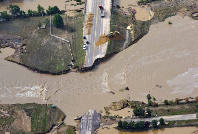
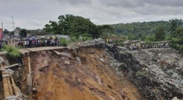
Last year's massive flooding in Colorado's Front Range affected a widespread area, destroyed roads and bridges, blocking access to residential areas for extended periods of time, and washed away homes. Based on a study conducted by the University of Colorado Boulder, the tweets sent during the flooding events played an important role in the preliminary reconnaissance of the infrastructure damage and helped geotechnical and structural engineers to more efficiently spend their time and efforts during their visit to the affected areas.
The particular study is among the first to examine the role of social media in engineering reconnaissance efforts. What differentiates it from past research in information systems is that it specifically focuses on non-emergency professionals, like engineers. In that context, tweets with photos and videos posted during the flood events provided a useful insight for the reconnaissance teams as to the extent and type of damage to different infrastructure systems. Even though the geo-tagged postings, which could be immediately mapped and processed, made up a 1.2 percent of the total tweets, they still composed a fairly accurate geographic distribution and time progression of the damage. A comparison between the damage-map issued by the city of Boulder and the map produced from the geo-tagged tweets comes to verify the above conclusion.
According to Shideh Dashti, an assistant professor of civil, environmental and architectural engineering at CU-Boulder and co-author of the paper, this type of information acquisition on infrastructure performance is particularly valuable for improving future infrastructure resilience, given the fact that frequently - the Colorado case included - reconnaissance teams cannot access the affected areas immediately after a natural disaster. One of the main issues that engineering reconnaissance teams encounter, is the short amount of time between their safe entrance to an area and the beginning of cleanup efforts, which sweeps away any evidence of infrastructure performance.
Prof. Dashti's future hope is the creation of a platform that will combine social media and self-reported information from citizens, perhaps through a mobile phone application. "My goal is to eventually feed information on damage distribution back to the user. You provide information and as a result, you gain access to live, mapped information provided by other users during a disaster."
Sources: UC Boulder, thedenverchannel.com
Nearby News
Want to read more like this story?

Twitter to help in real-time flood map generation!
Apr, 15, 2015 | NewsAs a flooding event is still in progress, real-time information on its extent and the population aff...
Reconnaissance of Natural Disasters
May, 13, 2020 | Education

The Berkeley Center for Smart Infrastructure: An interview with Prof. Kenichi Soga, Director of the Center
Feb, 26, 2024 | NewsThe following interview is from 2024 Special USA and Canada Geotechnical Business Directory edition...

La Habla earthquake and the role of social media in the information transmission
Apr, 01, 2014 | NewsOn Friday, March 28, a magnitude 5.1 earthquake hit the area of LA, 1 mile east of La Habra at a dep...

GEER reconnaissance report - Cephalonia island, Greece earthquakes 2014
Jun, 18, 2014 | NewsFollowing the intense seismic activity occurring in Cephalonia island, Greece, in January 26th and F...
Earthquake Reconnaissance
Apr, 09, 2020 | Education

More than 50% of U.S. infrastructure threatened by natural hazards
Jun, 08, 2021 | NewsAccording to a new study from the University of Colorado, Boulder, about 57% of infrastructure esta...

A mobile application for geologic hazards?
Mar, 21, 2014 | NewsWith 55% of its terrain located on areas prone to landslides, the Geotechnical Engineering Offi...

The Use of Small Unmanned Aerial Vehicles for Post-Disaster Geotechnical Reconnaissance Webinar Video Share
Dec, 23, 2016 | NewsThe Use of Small Unmanned Aerial Vehicles for Post-Disaster Geotechnical Reconnaissance Webinar outl...
On This Day
July 22nd 1818
READ MORE
Related Video

Trending
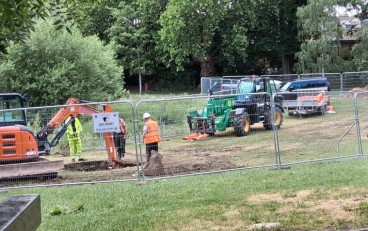
Brownfield success: Engineering excellence starts below ground

Scripting Comes to RS3: Automate, Customize, and Accelerate Your 3D Modelling

2D and 3D Analysis of Retaining Systems

Mine waste dam failure in Myanmar caught on video
Deadly mining landslide in Central African Republic raises safety concerns