GEER Report for Medicane Ianos Released: Documents thousands of landslides, bridge collapses and infrastructure damage Featured
The Geotechnical Extreme Events Reconnaissance (GEER) released a report documenting damage from Medicane Ianos. Medicane Ianos, a Mediterranean Hurricane, impacted Greece on September 17-20 2020. A total of 31 participants from 6 Universities, 3 governmental organizations and 3 companies participated in the effort. It was led by Dimitrios Zekkos, Associate Professor at the University of California at Berkeley, and George Zalachoris from Elxis Group, based in Greece.
During Medicane Ianos, the amount of precipitation during a duration of about ~48 hrs was among the highest recorded and exceeded, in certain areas, the mean annual precipitation. The extent of the affected area was very large and encompassed the western, central and southern Greece, all the way south to the island of Crete. The Ionian islands and the areas around Karditsa and Lamia in Central Greece were particularly affected.
Field deployments to collect perishable field performance data were supported by remote sensing tools and geospatial data analysis. The GEER team used optical and radar satellite imagery to generate a broad assessment of the conditions, as well as data-mined social media to identify sites of particular interest. On the ground, conventional site characterization tools were supplemented by Unmanned Aerial Vehicles to generate three dimensional models of target areas and sites. During field deployment, data collected in the field were uploaded on a shared Box folder and were projected on a web-based GIS map the next morning to facilitate collaboration among teams.
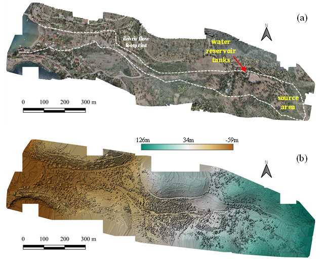
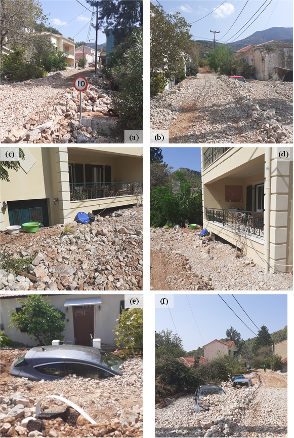
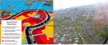
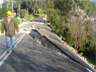
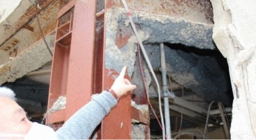
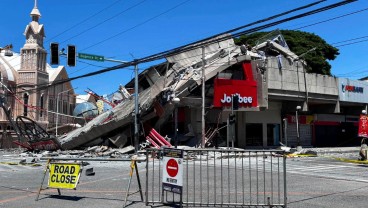
The amount of precipitation resulted in a wide variety a number of landslides. More than 1,400 landslides were mapped using satellite imagery and several debris flows devastated communities. Extensive flooding was also observed throughout the affected areas nationwide. Lower-elevation areas were flooded, and portions of the town of Karditsa and surrounding communities became completely submerged. The amount of water compromised, in numerous areas, the road and railroad network by washing out roads or railroad lines, damaging the embankments that supported the pavements, or disrupting their functionality by landslide debris. Particularly pronounced was the damage to many bridges, ranging from minor damages (such as movement) to complete collapse due to foundation scour, or lateral loads by water and debris. Riverbanks and levees were also overtopped and scoured.
Example photos from the GEER team response are provided below.
The report can be found on the GEER website here: http://geerassociation.org/index.php/component/geer_reports/?view=geerreports&layout=build&id=95
And as a pdf here: http://geerassociation.org/administrator/components/com_geer_reports/geerfiles/Medicane%20Lanos%20GEER%20Report.pdf
Report Citation: Zekkos D., Zalachoris G., Alvertos, A. E., Amatya P. M., Blunts P., Clark M., Dafis S., Farmakis I., Ganas A., Hille M., Kalimogiannis V., Karagiannidis A., Karantanellis E., Khan K., Kirshbaum D., Kourkoulis R., Kotroni V., Ktenidou O.-J., Lagouvardos K., Loli M., Makrinikas A., Marinos V., Manousakis J., Nikas K., Panousis D., Papathanassiou G., Saroglou C., Simopoulos A., Stanley T., Tsavalas A., Valkaniotis S. “The September 18-20 2020 Medicane Ianos Impact on Greece - Phase I Reconnaissance Report”. Geotechnical Extreme Events Reconnaissance Report, GEER-068, https://doi.org/10.18118/G6MT1T.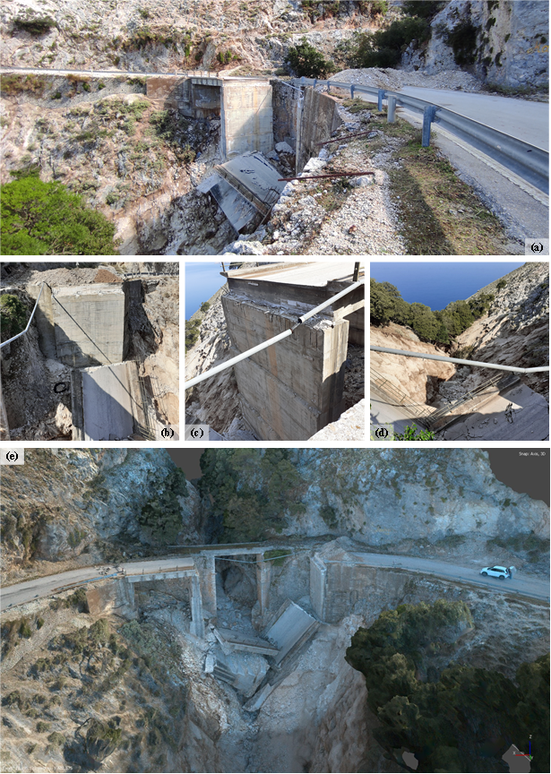


Want to read more like this story?

GEER report 2021 Western European Flooding published and available online!
Oct, 26, 2022 | NewsRecord rainfall triggered devastating and deadly flooding in Western Europe between July 14-16th, 2...

GEER reconnaissance report - Cephalonia island, Greece earthquakes 2014
Jun, 18, 2014 | NewsFollowing the intense seismic activity occurring in Cephalonia island, Greece, in January 26th and F...

Useful preliminary findings from the earthquake sequence in central Italy unveiled by an Italy-US GEER team's engineering reconnaissance
Sep, 19, 2016 | NewsUseful preliminary findings from the earthquake sequence in central Italy unveiled by an Italy-US GE...
GEER Report announcement - Christchurch New Zealand 2014
Jun, 24, 2014 | NewsGEER report on "Geotechnical & Flooding Reconnaissance of the 2014 March Flood Event Post 2...

Greece struck by powerful Mediterranean hurricane: Floods and destruction across the country
Sep, 17, 2020 | News3 people have been confirmed dead and 2 more are missing after a powerful hurricane struck Greece....

New GEER report on the 2014 Iquique, Chile Earthquake
Oct, 27, 2014 | NewsA new GEER report was recently released on the geotechnical aspects of the April 1, 2014 M8.2 I...

Central Texas Floods-May 23-25, 2015
Jun, 15, 2015 | NewsSignificant rainfall moved across Central Texas over Memorial Day Weekend, May 23-25, 2015, causing...

Introduction to Slope Stability
Mar, 03, 2021 | EducationTopics on Slope Stability Analysis Geoengineer.org has gathered and presented educational mate...
Cephalonia earthquakes: EERI and GEER to investigate the seismic activity impact
Feb, 08, 2014 | NewsGEER (Geotechnical Extreme Event Reconnaissance) Association in collaboration with EERI (Earthquake...
On This Day
July 19th 1900
READ MORE
Related Video

Trending

China's Three Gorges Dam under pressure: Flood hazard downstream

Functional requirements of foundation structures


Landslide in Papua New Guinea: At least 12 people dead

Asbestos remains a deadly infrastructure risk across the UK
Major earthquake in southern Philippines causes deaths and widespread damage