Slow-moving landslide discovered near the 2014 Oso landslide site in Washington

Signs of the landslide were first discovered on Tuesday, April 4 by Washington's Department of Transportation workers, who noticed cracks on a hillside road.
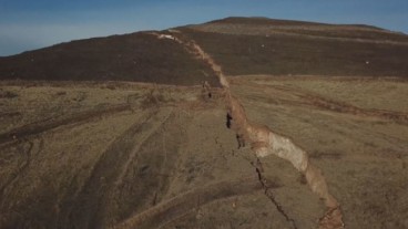
The slide is about 1.5 miles west of the massive 2014 Oso landslide that killed 43 people – it is located on the opposite side of Highway 530, in Washington's Snohomish County.
Cracks in the roadway were about 6 inches wide on Tuesday, but had increased to 2 feet wide by Saturday, April 8. According to officials, the hillside has dropped about 4 feet vertically. Geologists from the state Department of Natural Resources (DNR) conducted an investigation on Friday and Saturday, trying to get a sense of how fast the landslide could be moving. DNR has placed monitors and sensors near the landslide and continues to evaluate movements during the weekend.
Although there is no debris from the landslide on Highway 530, the highway is closed from Oso Loop Road to C-Post Road as a precaution, according to the state's Transportation Department. The department will reassess the situation on Monday, April 10, and if no additional movement occurs, probably the highway will reopen.
On Friday night, officials recommended that people living in 10 homes nearby should evacuate - residents of eight homes did.
Source: The Seattle Times
Nearby News
Want to read more like this story?
Landslides
Oct, 31, 2019 | Education
Monitoring a slow-moving landslide in Washington state
Jan, 11, 2019 | NewsA slow-moving landslide, located on Rattlesnake Ridge beyond Union Gap, Wash, will be monitored by t...

Landslide swept away section of Highway 1 in California
Feb, 08, 2021 | NewsA 45-meter section of California's Highway 1 has been swept away by a large landslide. Highway 1 is...

5 years from the tremendous Oso landslide
Mar, 26, 2019 | NewsThe families of the unfortunate victims that lost their lives due to the catastrophic Oso landslide...

Landslide in Whidbey Island, Washington, takes down one house, threatens more
Mar, 27, 2013 | NewsA landslide has occurred at 4:15 am on Wednesday morning in Whidbey island. Nobody was killed, but t...

Update on the massive mudslide in Washington: Aerial views of the area before and after the event, as casualties climb up to 25.
Mar, 23, 2014 | NewsThe landslide occurring early Saturday morning on March 22nd, near Arlington WA, came as a result of...

Washington employs LiDAR technology against landslide risk
Jan, 25, 2017 | NewsWashington's Department of Natural Resources (DNR) is making use of the best technology available to...

How possible is a next Oso landslide event?
Feb, 27, 2015 | NewsSince the Oso landslide, the emerging question in many meetings, panel discussions and brainstorming...

Deadly landslide occurs in Sichuan province, China
Jun, 25, 2017 | NewsFifteen people have been confirmed dead and more than 100 are still missing, due to the landslide th...
On This Day
July 17th 1886
READ MORE
Related Video

Trending

Life after gINT - Rethinking geotechnical data management for a new era

Is Africa gradually splitting into two sections?

Stop Guessing, Start Designing: Introducing Support Designer in Slide2


Alert level is raised in Mexico as the Popocatépetl volcano spews ash and gas

Major wastewater tunnel procurement begins in southern Sweden