New study suggests a method to replenish depleted aquifers
Scientists from Stanford University have introduced a new method to replenish aquifers by using flooding fields.
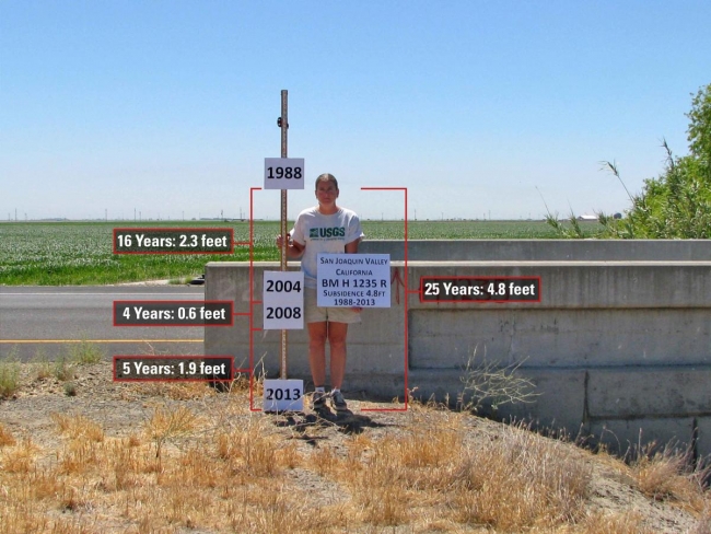
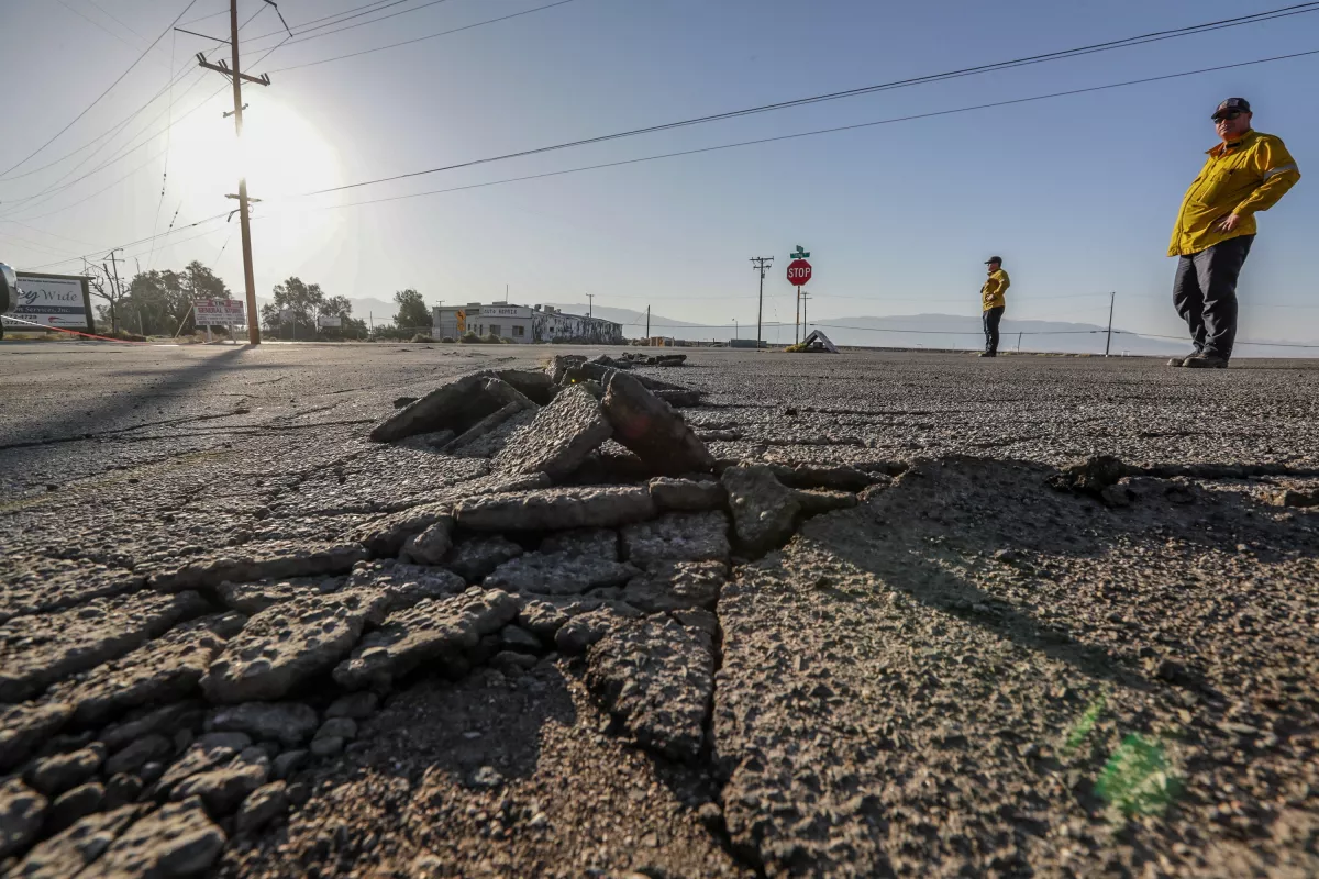
The research focuses on California where overpumping has caused severe settlements in agricultural regions.
In particular, the settlement in some parts of the Central Valley during the period between 1900 and 1950 has reached up to 8.5 meters. Currently, some areas are sinking at a rate of 0.2 meters annually and, therefore, the ground could sink by another 4 meters in the next decades causing devastating damage to infrastructure.
The method of flooding fields to refill the aquifers and stop sinking is not a new idea but its application is challenging. The authors of the study, Rosemary Knight, Professor at Stanford's School of Earth, Energy & Environmental Sciences and Ryan Smith, Professor at Missouri University of Science and Technology have found an approach that is based on combining 2 types of remote sensing data and will be able to predict where and how to implement it.
They analyzed the soil layers that consist of sand and clay deposits in 3 sites by transmitting electromagnetic signals from a helicopter and they utilized data from public satellite images to measure the ground's settlement. "I realized that both of the datasets were linked to clay content. I thought, if there's a mathematical way to connect these two, then we could build a predictive model of subsidence," Prof. Smith stated. The study presents a technique to incorporate the 2 datasets into the existing models that predict soil's subsidence.
Flooding fields is a method that should be implemented wisely. "The key question is where does the water go? If you're going to flood a farmer's field, you should be sure it's going to work," Prof. Knight said. The sand and clay layers should be mapped in order to know where water will head underground (sand is a permeable deposit while clay is practically impermeable). Currently, only a small proportion of California has been mapped by both types of remote sensing and according to Tim Godwin, senior engineering geologist with the California Department of Water Resources, gathering and combining new data will highly improve the settlements prediction model. "Groundwater managers will be able to more accurately predict susceptibility to subsidence conditions and have greater confidence in proposed projects," Godwin commented.
Source: Stanford.edu
Want to read more like this story?

California is sinking
Aug, 26, 2015 | NewsCalifornia enters the fifth year of a drought and more and more water is pumped from the aquifer....

How much sand do we have left? New transport equations for carbonate deposits
Jun, 12, 2020 | NewsA new study provides insights and suggests new models on carbonate sand deposits movements. The stu...
Soil Settlement
May, 13, 2019 | EducationSettlements refer to the soil’s movement in the vertical direction typically induced by stress chan...

Estimating Settlement of Shallow Foundations on Granular Soils
Apr, 10, 2025 | NewsShallow foundations often give the illusion of simplicity—concrete blocks resting on firm ground, c...

California expands groundwater and subsidence monitoring statewide
Oct, 10, 2025 | NewsCalifornia’s Department of Water Resources (DWR) has launched a major expansion of its groundwater...
Study presents new insights about the depletion of the world's groundwater storages
Aug, 27, 2020 | NewsAccording to a new study, the vast proportion of groundwater stores has not changed in recent years...
Changes in magnetic field along fault lines preceded major earthquakes in California according to a recent case-study
Oct, 13, 2022 | NewsResearchers have tried for decades to determine whether there is a reliable precursor that can act...

The phenomenon of Quick Clays
Jul, 03, 2020 | EducationIntroduction Quick clay refers to a specific type of clayey material that experiences a significa...

The Rising Threat of Groundwater Flooding: Risks and GeoEngineering Solutions
Feb, 28, 2025 | NewsGroundwater flooding is an often-overlooked hazard, but as climate change intensifies, its risks ar...
On This Day
July 22nd 1869
READ MORE
Related Video

Trending
Seven Frequently Asked Questions about Helical Piles

Block caving: A new mining method arises

Categories of isolated foundation footings
Maharashtra's longest road tunnel to be completed soon

Carnian Pluvial Episode: That time when it rained for 1-2 million years

Stop Guessing, Start Designing: Introducing Support Designer in Slide2
Development program prepares new engineers for success