M 6.0 earthquake struck near the border of California and Nevada: Rockslides close a major route
A M 6.0 earthquake struck near the California and Nevada border on July 8, 2020. The seismic shock triggered rockslides along a major highway but, fortunately, no injuries were reported.
The earthquake occurred at around 3:50 p.m. local time in Antelope Valley about 400 kilometers east of San Francisco, California. Earthquakes in the area of interest usually occur along normal or strike-slip faults. According to the United States Geological Survey (USGS), the current seismic shock was a result of tectonic movement along a moderately dipping, normal fault on the North American Plate. It hit on the eastern section of Sierra Nevada which comprises a physical boundary along the border of California and Nevada. The Sierra Nevada microplate is part of the Pacific-North America plate boundary system and moves at around 1,2 cm annually relative to the North American Plate.
The epicentral depth of the temblor was 7.5 kilometers and it was followed by many shocks with the largest being M 4.6. The earthquake was felt as far as Las Vegas with many communities in California and Nevada being affected. The geologic formations in the Sierra Nevada comprise hard rocks that result in little attenuation of the generated seismic waves. This is why the temblor was felt in large distances. "...the mountains [of Sierra Nevada] ring like a bell when an earthquake happens there. So they transmit the earthquake energy really well,” Keith Knudsen, deputy director of the USGS’ Earthquake Science Center, stated. Despite reportedly being the largest seismic shock to strike the region since 1994, no significant infrastructure damage or injuries were reported.
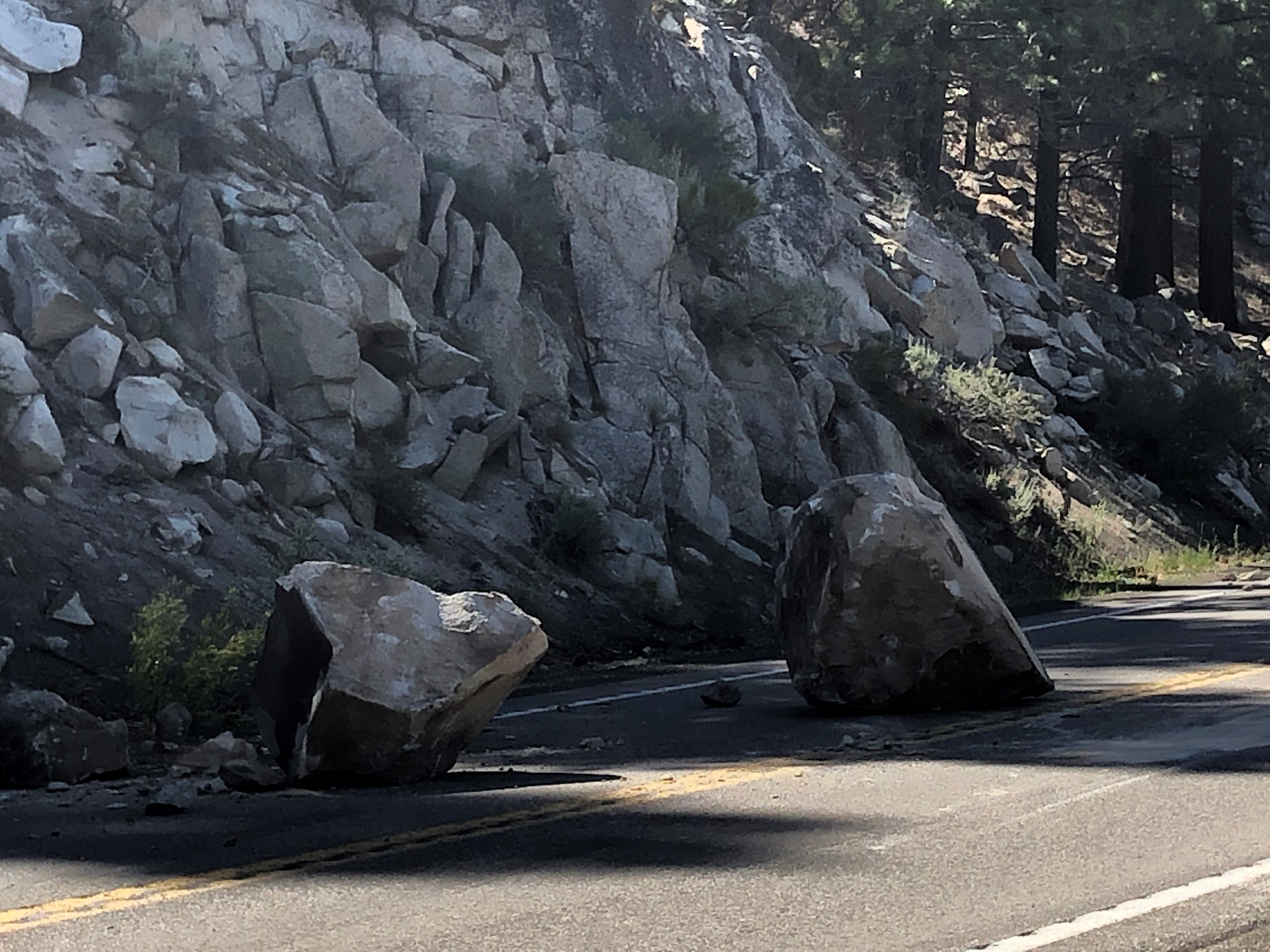
A series of rockslides triggered by the seismic shock resulted in the closure of US 395, a major route in the western United States that travels from the US-Canadian border in the north to the Mojave Desert in the south. In particular, about 64 kilometers of the route near the community of Willow Springs in Mono county were impacted by the ground failures with some vehicles being hit but with no injuries reported. Photographs retrieved from the site show large boulders scattered in many sections of the highway. Some people made attempts to remove them but many were massive and could not be readily displaced. A witness mentioned that “boulders the size of cars” fell onto the highway in one location. The Utah Geological Survey suggests that rockfalls are one of the most common types of ground failures caused by earthquakes greater than M 4.0 in the region.
Some of the rockslides were caught on camera. Click on the video below to watch the impressive footage.
Last month, an intense earthquake sequence puzzled southern California. More than 600 seismic shocks with the greater being of M 5.3 were recorded near the border with Mexico. The epicenters of the quakes were located near Calipatria, a city in Imperial County, California. Nonetheless, the wider region is not densely populated and hence, the impact of the earthquakes was minor.
Sources: NYpost, CNN, Guardian, USGS, Independent
Media
- Rock Slide From CA Earthquake Caught On Camera
- NBC News
Want to read more like this story?

The largest earthquake in 66 years struck Nevada
May, 15, 2020 | NewsA M 6.5 earthquake that hit on Friday, May 15, 2020 is the largest one to occur in Nevada since 195...

Two powerful earthquakes hit China: Reports of 3 people dead
May, 21, 2021 | NewsTwo separate, strong earthquakes that struck in China have resulted in, at least, 3 fatalities. The...

Powerful earthquake struck Mexico: At least one fatality
Sep, 08, 2021 | NewsAt least one person died after a M 7.0 earthquake hit southwestern Mexico on September 8, 2021. Th...

Massive 7,1-Magnitude earthquake struck California
Jul, 05, 2019 | NewsA powerful 7,1-magnitude temblor struck in the Mojave Desert (near Ridgecrest) located about 200 ki...

Massive earthquake struck off the coast of New Zealand
Jun, 18, 2020 | NewsA M 7.4 earthquake struck off the coast of New Zealand raising concerns about a potential tsunami....

Powerful earthquake strikes Idaho, United States
Mar, 31, 2020 | NewsA M 6,5 earthquake struck Idaho, United States on Tuesday, March 31, 2020. According to the U.S. Ge...

Study suggests that smaller earthquakes generate most strong ground motions
Jan, 04, 2021 | NewsAccording to a new study, smaller earthquakes have caused the strongest shaking incidents in the vi...

M 6,0 seismic shock hits China causing at least 3 fatalities
Sep, 15, 2021 | NewsAt least 3 people have died after a M6.0 struck southwestern China. The seismic shock occurred on S...

M 7.5 earthquake hit Alaska triggering tsunami warnings
Oct, 19, 2020 | NewsA tsunami warning was issued after a powerful earthquake hit Alaska's southern coast. The M 7.5...
On This Day

Related Video

Trending

Unstable Ground: Lessons from the I-80 New Jersey Sinkhole Saga

Seequent announced extended gINT support until Dec 31, 2028

New Release: GeoStudio 2025.2


Artificial Ground Freezing: Applications, Techniques, and Key Considerations
Deadly mining landslide in Central African Republic raises safety concerns