Introducing New Technologies for Geotechnical Infrastructure Sensing & Monitoring
- May, 20, 2021 - May, 21, 2021
- Webinar Geomatics Site Characterization & In-Situ Testing (General)
- English
- Authored by: Alexandros Tsavalas
- Introduce the concepts of digital twins and the new observational method
- Understand the principles of operation of each technology and its advantages and limitations
- Review examples of applications of the technologies in actual geotechnical projects
- Provide guidance on how one could implement these technologies in engineering practice.
Register to the two-day course!
Course Schedule
The course will be offered in real-time (synchronous) from 9:00 to 17:00 Pacific time and includes time for discussion with the instructors. Participants will also be able to listen to the lectures in different time zones, in recorded format (asynchronous). The recordings will be available to all participants for viewing for one week.
DAY 1: 9:00-17:00 PST
Part 1: Introduction and The Big Picture of Geotechnical Infrastructure Monitoring
9:00-9:15: Introduction – Welcome (15 min) (Zekkos, Kayen, Soga)
9:15-10:00: Review of Current and New Technologies and Hierarchy – Digital Twins and data management frameworks – New Observational Method (45 min) (Soga & Zekkos)
10:00-10:30: Means for Sensing (30 min) (Zekkos)
- Satellites
- Aerial
- Terrestrial
- UAV
- In-situ
Part 2: New Technologies for geotechnical monitoring: Remote and non-contact Sensing
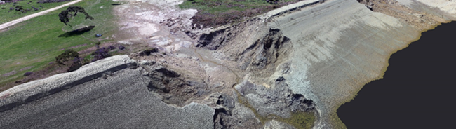
10:30-11:30: UAVs and Optical data collection (1 hr) (Zekkos)
11:30-12:30: Structure-from-Motion (1 hr) (Zekkos)
12:30-13:30 - 1 hr break – discussion - chat
13:30-14:00: RTK GPS (Kayen)
14:00-15:00: LiDAR (Kayen)
15:00-16:00: Data Analysis using 3D models (Zekkos)
16:00-17:00 Discussion - Chat (optional)
DAY 2: 9:00-17:00
Part 2: New Technologies for geotechnical monitoring: Remote and non-contact Sensing (Continued)
9:00-10:00: Synthetic Aperture Radar (SAR) (Kayen)
10:00-11:00 UAV-based Infrared - Principles and Applications (1 hr) (Zekkos)
Part 3: New Technologies for geotechnical monitoring: Embedded Sensing
11:00-12:30 Wireless Sensing applications – Principles and Applications (1.5 hr) (Soga)
12:30-13:30 break
13:30-14:30 The ShapeArray (Johnson)
14:30- 16:30 Fiber Optics (Soga)
Part 4: Conclusion
16:30-17:00 Putting it all together–how to optimize your design using monitoring data (1 hr) (Kayen, Soga, Zekkos)
17:00-18:00 Discussion - Chat (optional)
Deliverables
- 14 hrs of online lectures – Available for real-time and non-real-time viewing during the course delivery as well as non-real-time (i.e., asynchronous). Registered participants will be able to view the presentations for an entire week following the completion of the course through a password-protected website.
- 700+ course slides
- Recommended Technical literature for each specific technology/theme
- Office hours (instructors available for discussion in break-out rooms at the end of each day of course delivery, as well as a week later)
The cost of this two-day course is $985.
A 10% reduction in cost is provided for 3-4 registrations and a 20% off for 5+ registrations (if paid at the same time during course registration).
Want to read more like this?

Introducing New Technologies for Geotechnical Infrastructure Sensing & Monitoring
Dec, 16, 2020 | EventThe objective of this course is to introduce a wide range of new technologies for geo-infrastructur...

Introducing New Technologies for Geotechnical Infrastructure Sensing & Monitoring
Feb, 04, 2022 | EventThe objective of this course is to introduce a wide range of new technologies for geo-infrastructur...

Introducing New Technologies for Geotechnical Infrastructure Sensing & Monitoring
Mar, 29, 2023 | EventThe objective of this course is to introduce a wide range of new technologies for geo-infrastructur...

CLaSH invites you to join us for the 2023 Land Surface Hazards Modeling Expo!
May, 01, 2023 | NewsThe Center for Land-Surface Hazards (CLaSH) invites you to the 2023 Land Surface Hazards Modeling E...

2023 Land Surface Hazards Modeling Expo
Apr, 18, 2023 | EventAs the geoscience community confronts the challenges of interpreting and predicting the behavior of...

New Technologies for Geotechnical Infrastructure Sensing and & Monitoring 2025
Sep, 17, 2025 | EventOn November 17-20 2025, UC Berkeley Faculty and collaborators will be offering again a short course...

TC218 Webinar on Load Carrying MSE Bridge Abutment
Jun, 11, 2024 | EventTC218 - Technical Committee on Reinforced Fill Structures is pleased to announce the upcoming TC218...

Geotechnical Earthquake Engineering - A Berkeley Virtual Short Course Series
Nov, 13, 2024 | EventUC Berkeley faculty does it again! The "Geotechnical Earthquake Engineering" series is offered from...

Geotechnical Earthquake Engineering - A Berkeley Virtual Short Course Series
Dec, 07, 2023 | EventUC Berkeley faculty does it again! A brand new short course series is offered from February to Ap...
On This Day
July 18th 1635
READ MORE
Related Video

Trending

Plaxis 2D/3D Basic Course – Online Training


Piling & Ground Improvement Conference 2026 (DFI-PFSF)
Reading the Rock: Structurally Controlled Slope Instabilities with DIPS and RocSlope2

Course: Slope Stability Analysis of Open Pit Coal Mine Excavations and Waste Dumps
