As a flooding event is still in progress, real-time information on its extent and the population affected is difficult to obtain, putting rescue crews and associated agencies in a difficult position in terms of planning and decision making. A joint study carried out by two Dutch organizations - Deltares and Floodtags - aims in developing twitter-based real-time flood maps. The project is considered a proof of concept and was presented at the General Assembly of the European Geosciences Union taking place in Vienna these days.
Following the conventional way, flood maps are being derived from post-flooding sources such as satellite and areal images, ground observations, hydrodynamic models and post-flooding flood marks. But the use of social media during a flooding event may prove a very useful resource of real-time information which can then be used to compile real-time flood extent maps. A recent example of the social media power is found in Jakarta, the Twitter capital of the world, where flood-related tweets reached a peak of 900 tweets a minute during the catastrophic flooding events of February 2015. Despite the uncertainties involved in the quality of the provided information, a great amount of the specific tweets contained information on the depth of water and the location. Provided that this cloud of information, is carefully filtered, evaluated and enriched, it could become a powerful tool in the hands of scientists and disaster managers
Upon full implementation, the method will be able to create real-time maps, based on people's tweets "giving crisis managers a better view of what is actually happening during a flood so they can make more effective decisions: the right measures at the right time, in the right place", according to Dirk Eilander's statement, a flood expert in Deltares. The specific flood maps are expected to be used post-flooding, in the calibration of hydrodynamic models as well as by insurance companies in getting information about damaged areas.
Watch the live press conference about this new tool here!
Source: Deltares
Nearby News
Want to read more like this story?
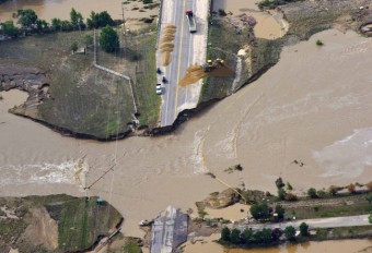
How can twitter help engineers assess infrastructure performance: the Colorado floods case
Sep, 04, 2014 | NewsLast year's massive flooding in Colorado's Front Range affected a widespread area, destroyed roads a...

New parameter in flood risk assessment recent study reveals
Jan, 28, 2015 | NewsWith half a million dollars spent to adress direct flooding costs in the U.S. in 2012, flood risk ev...

Satellite nightlight images shed light on human exposure to floods
Nov, 26, 2014 | NewsAccording to a recent study, the number of people living in flood susceptible regions has increased...

La Habla earthquake and the role of social media in the information transmission
Apr, 01, 2014 | NewsOn Friday, March 28, a magnitude 5.1 earthquake hit the area of LA, 1 mile east of La Habra at a dep...

Geology, Heavy Rainfall, and Warning Gaps: Unpacking the Deadly Texas Flood Disaster
Jul, 04, 2025 | NewsIn the early hours of July 4th, 2025, a powerful storm system swept across central Texas, dropping...

The Rising Threat of Groundwater Flooding: Risks and GeoEngineering Solutions
Feb, 28, 2025 | NewsGroundwater flooding is an often-overlooked hazard, but as climate change intensifies, its risks ar...
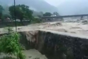
Flood Waters in Nepal Break Through Defense Wall (Video)
Jul, 27, 2016 | NewsHeavy rainfall in Nepal continues and mass flooding is causing severe damage. Flash flooding and lan...

Report indicates that sea level rise will make many US coastal areas prone to flooding
Jul, 23, 2014 | NewsNon-profit's organization survey and analyses on climate change, point out that South and...
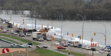
Manitoba floods urging for military assistance and even deliberate flooding of areas
Jul, 07, 2014 | NewsWater rise in Saskatchewan is flooding Manitoba, while officials are declaring the province in...
On This Day

Related Video

Trending

Quick Clay Failure on Norway’s E6 at Levanger

Keller North America announces recent leadership changes


Fulgurite: A rare phenomenon
Tailrace tunnel breakthrough advances Australia’s largest renewable project

A Legacy of Leadership, Mentorship & Service: Gary L. Seider P.E.