New insights about the seismic hazard of New Madrid area, Missouri
Scientists have attempted to shed light on the earthquake vulnerability of the area around New Madrid, Missouri.
About 200 years ago, the aforementioned region experienced a sequence of massive (about 8.0 magnitude) seismic incidents. These earthquakes resulted in building collapses and soil liquefaction. The final event, which was also the most severe, occurred on Reelfoot fault and altered the course of the Mississippi River.
Investigations have shown that other series of such earthquakes have been recorded earlier in this area. Therefore, New Madrid is characterized as an earthquake-prone zone for future events.
Ryan Gold of the U.S. Geological Survey (USGS) stated: "We know there were also large earthquakes at around 1450 AD and 900 AD." However, not all earthquakes occur along the Reelfoot fault. Gold assumed that the scrap linked with the Reelfoot fault shows that earthquakes haven't been sustained for a long time. "If earthquakes happen on the Reelfoot fault every 500 years, and have been doing so for hundreds of thousands of years, we would expect to see a mountain range there—but we don't," he commented.
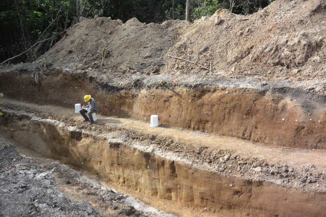
To put Gold's theory to the test, USGS scientists decided to investigate deeper into the past. This procedure proved to be challenging as sustaining records from past earthquakes is a difficult task due to natural phenomena (e.g. rain and floods) and anthropogenic activity.
The researchers decided to study the hills of the Mississippi River, east of the Reelfoot fault. They noticed high concentration of depressions and they assumed that these depressions are cracks in the ground caused by big earthquakes.
A trench was excavated in one of the depressions that had formed in Peoria loess. According to USGS, the trench revealed four distinct packages of sediment which corresponded to earthquakes previously detected in Reelfoot's fault: 1812 AD, around 1450 AD, around 900 AD and around 2300 BC. Gold said: "Our record confirms that the tempo of earthquakes hasn't been sustained,".
USGS team believes that the results of the investigation can provide new insights concerning the seismic hazard of the region. It is possible that these data will provoke alterations and updates in the construction design codes.
Source: Geosociety.org
Want to read more like this story?

Study suggests that smaller earthquakes generate most strong ground motions
Jan, 04, 2021 | NewsAccording to a new study, smaller earthquakes have caused the strongest shaking incidents in the vi...
New AI method to detect microearthquakes
Dec, 07, 2020 | NewsScientists from Stanford University and Georgia Institute of Technology in the United States, intro...

Massive earthquake struck off the coast of New Zealand
Jun, 18, 2020 | NewsA M 7.4 earthquake struck off the coast of New Zealand raising concerns about a potential tsunami....
Geotechnical Earthquake Engineering
Apr, 21, 2020 | Education

Researchers Develop Theory Behind New Madrid Earthquakes
Sep, 22, 2016 | NewsResearchers along with USGS believe they may have developed a theory to explain the mid-plate earthq...

Earthquakes triggered by landslides
Jul, 02, 2020 | NewsIt is widely known that earthquakes can trigger disastrous landslides but, what about the opposite?...

Deep landslides triggered by the 1964 Alaska earthquake were not re-activated in the 2018 Anchorage earthquake
Oct, 29, 2019 | NewsAccording to a new study, published in Seismological Research Letters, the deep landslides that wer...

16 States at high risk of earthquake according to updated USGS map
Jul, 18, 2014 | NewsA new report with updated earthquake maps, issued by the U.S. Geological Survey, reveals the 16 stat...
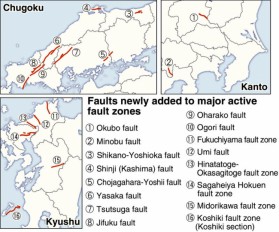
Sixteen new locations listed as major active fault zones in Japan
Feb, 22, 2017 | NewsThe total number of major active faults in the country has now increased to 113, as the Headquarters...
On This Day
July 30th 1627
READ MORE
Trending

Embankment Collapse on NH-66 in Kooriyad Triggers Engineering and Oversight Review

Fehmarnbelt tunnel advances with first element ready for immersion

Geotechnical Engineering 2032 Boom: Trends, Challenges, and Emerging Opportunities
Emergency protocols activated following offshore 7.7 magnitude earthquake in Japan

Stop Guessing, Start Designing: Introducing Support Designer in Slide2
Development program prepares new engineers for success