Uncovering the Hidden Benefits of Buying New Software Sponsored

Technology has moved on a great deal in the last five years and clients are increasingly demanding geotechnical data to be included in models and drawings.
Technology has moved on a great deal in the last five years and clients are increasingly demanding geotechnical data to be included in models and drawings. As a result, it is an ideal time for companies to review their software systems and practices, but many organizations are reluctant to invest time and money in new systems. However, market-leading firms continually invest in their businesses to stay ahead of the competition – and this includes geotechnical CAD and BIM software.
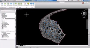
Peter Brett Associates replaced their gINT system with HoleBASE SI and the extension for AutoCAD Civil 3D, which has saved them a lot of time and is delivering huge cost savings.
As David Cotton says, “The projects we use the software on are really diverse, but we mostly deal with ground investigations from projects with just a few holes to ones with 400+ locations. It’s been a big cost saving and reduction in time to be able to generate these investigations almost instantly; with the added dynamic capability of the Civil 3D extension you can just click a button and it appears. Alignments can then be dragged into place and the software automatically updates for you. “Over the 2-3 years I’ve been using HoleBASE SI I’ve seen a huge improvement in the features and Keynetix are clearly listening to the industry with regular updates to suit wish lists and individual requirements.”
Keynetix has developed a Geotechnical CAD Cost Calculator to help companies review their own projects and to quickly work out the costs and potential savings that could be made and to evaluate if there is a business case to change. The calculator can show whether this a good short or medium term investment and of course indicates where process efficiencies can be made.

Read the full article for more information and download the calculator to find out if your geotechnical CAD/BIM team is costing you more than it should.
Source: Keynetix
Want to read more like this story?

Driving better value with geotechnical BIM
Jul, 19, 2017 | NewsSite investigations are fundamentally about identifying anomalies in the ground that, if left unide...
Other Geotechnical
Jun, 04, 2019 | Education

Keynetix leads significant BIM for the subsurface Project; expected to be completed in 2017
Jun, 10, 2015 | NewsA cloud-based database of UK geological and geotechnical data and 3D ground models could soon become...
Watch Keynetix's video and learn how to display Boring Data in AutoCAD Civil 3D!
Mar, 04, 2015 | NewsIn this video you will learn the best practice for importing and displaying borehole data into the G...

Keynetix User Group and Conference 2014 Review
Nov, 25, 2014 | NewsOn Tuesday November 11th 2014 Keynetix hosted this year’s User Group Meeting and Conference. This ye...

Keynetix's HoleBASE used in Doseley quarry re-development project!
Apr, 30, 2015 | NewsRemediation of the former basalt quarry in Doseley, near Telford, for a residential development is d...

Learn more about the new AutoCAD Civil 3D Geotechnical Module with Keynetix
Jun, 21, 2017 | NewsKeynetix is offering a free webinar explaining the new features and capabilities of the Geotechnical...

Keynetix Webinars Series 9: Revolutionise your CAD modelling with HoleBASE SI Extension for AutoCAD
Apr, 22, 2019 | EventAfter man years of re-development the new look Extension for AutoCAD Civil 3D has been released to a...

Keynetix develops Geotechnical Module for AutoCAD Civil 3D 2015
Aug, 07, 2014 | NewsKeynetix has recently developed a new Geotechnical module, which is incorporated into AutoCAD Civil...
Form
Looking for more information? Fill in the form and we will contact Bentley for you. Alternatively, you can visit Bentley's website and speak with a Bentley Geotechnical Expert.
On This Day
July 19th 1985
READ MORE
Related Video

Trending

China's Three Gorges Dam under pressure: Flood hazard downstream

Functional requirements of foundation structures


Landslide in Papua New Guinea: At least 12 people dead


Stop Guessing, Start Designing: Introducing Support Designer in Slide2
Development program prepares new engineers for success