Civil Beta Partners Wanted; Inspirational Visualisation Sponsored
It is often said a picture paints a 1,000 words and with today's technology, visualisation is being used more and more to portray and present complex information. This is one of the major reasons why Keynetix chose to stop development on KeyHole and move to the AutoCAD Civil 3D platform with the HoleBASE SI extension, this environment opens up as many opportunities.
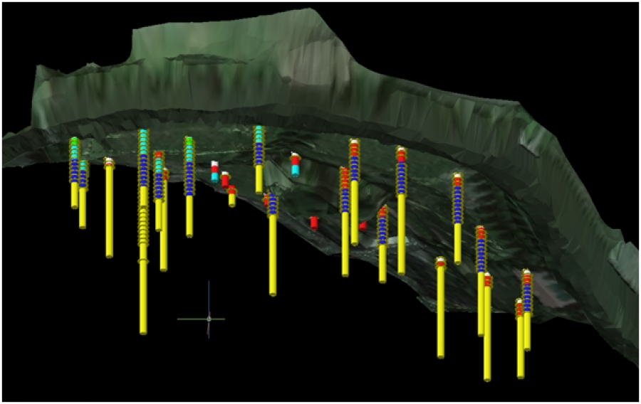
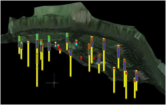
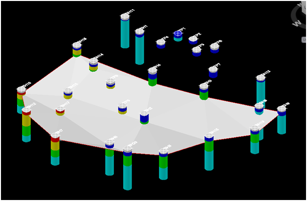
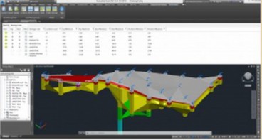
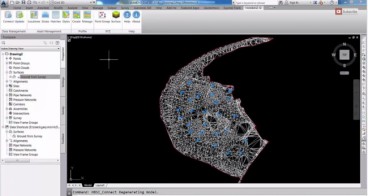
Keynetix are currently hard at work developing the next version of the HoleBASE SI extension for AutoCAD Civil 3D, the new core will be faster, more stable and have better integration with HoleBASE SI than the first release. As part of this development work, they are implementing the HoleBASE SI XYZ functionality in the civil extension. This will allow any down hole data to be plotted as either point groups or surfaces in AutoCAD Civil 3D. For instance, one can represent the locations of all samples, or plot the water table surface. You can see these examples illustrated in the media gallery just below this news article.
Keynetix now need your help, your imagination, on how you want geotechnical data presented in 3D. Gary Morin from Keynetix would be very grateful if you could send him in the email provided at the end of this news item, example drawings or images that have been produced (by any means) to represent down hole information in a 3D model, Keynetix can then use these as examples of what they should try to achieve in plotting down hole XYZ information i.e CPT plots, Sample Locations, Contamination Levels, Water Strikes etc. Please don’t be constrained by how Keyhole worked, think of what you need to see to better understand the data or to present and explain to others. Keynetix could use symbols sized in three dimensions, colours, labels, alter the cylinder diameter to represent values at a certain depth and many more techniques.
Keynetix will keep any information sent to them confidential and will use it for shaping the functionality and tools that they are developing within the extension. In the words of Gary Moring: "It is very important that we have your input at this stage as it allows us to design software to better meet your requirements."
If you have any questions then please don’t hesitate to contact Gary Morin at [email protected]
Source: Keynetix
Image Gallery
Want to read more like this story?
Keynetix: New Release for Autodesk Geotechnical Module !
Jun, 25, 2015 | NewsKeynetix are delighted to announce that Autodesk have released the latest version of the Autodesk Ge...

Keynetix develops Geotechnical Module for AutoCAD Civil 3D 2015
Aug, 07, 2014 | NewsKeynetix has recently developed a new Geotechnical module, which is incorporated into AutoCAD Civil...

Keynetix Webinars Series 9: Revolutionise your CAD modelling with HoleBASE SI Extension for AutoCAD
Apr, 22, 2019 | EventAfter man years of re-development the new look Extension for AutoCAD Civil 3D has been released to a...

New Youtube video from Keynetix: Modelling Geology fault in AutoCAD Civil 3D
Jun, 26, 2014 | NewsFollowing the success of the first YouTube video on AutoCAD Civil 3D, Keynetix is pleased to present...
Watch Keynetix's video and learn how to display Boring Data in AutoCAD Civil 3D!
Mar, 04, 2015 | NewsIn this video you will learn the best practice for importing and displaying borehole data into the G...

Keynetix: Watch this fantastic Visualization on presenting 3D borehole models!
Mar, 27, 2015 | NewsIn this video you will learn how to transform your Geotechnical Data using a 3D Borehole Model...

New AutoCAD Civil 3D Geotechnical Module boosts usability
Aug, 26, 2016 | NewsAutodesk’s Geotechnical Module for AutoCAD Civil 3D 2017 makes it even easier to integrate and visu...

Read about Keynetix's Software Compatibility Within Windows 10
Sep, 11, 2015 | NewsOver the past few months Keynetix Ltd. has been testing its full software suite within the new...

New Features for Keynetix's HoleBASE SI !
Oct, 16, 2015 | NewsKeynetix Ltd. is excited to announce that its Development Team has been working full time developing...
Form
Looking for more information? Fill in the form and we will contact Bentley for you. Alternatively, you can visit Bentley's website and speak with a Bentley Geotechnical Expert.
On This Day
July 22nd 2013
READ MORE
Related Video

Trending

Chesapeake Bay Bridge-Tunnel: An ‘engineering wonder’ of the modern world

What controls the height of the world's mountains?

AI-enhanced landslide model ready for 2026 deployment in Hong Kong
Deadly mining landslide in Central African Republic raises safety concerns