50th anniversary of the 9.2 magnitude Great Alaska Earthquake and Tsunami

On March 27 1964 a 9.2 magnitude earthquake, the largest ever recorder in the U.S., shook Alaska for about 5minutes, and was followed by a 100ft high tsunami. The earthquake and tsunami combined, caused about $2.3billion in property loss and hit a death toll of 131. Today, on the 50th anniversary of the Great Alaska Earthquake, it is widely recognized that the particular earthquake event set the ground for great advancements in earth science. Read more on the research breakthroughs of the last 50years, followed by videos with technical information, and watch survivors describing their personal experience from that day.
Survivors of the Alaska earthquake describe in the most dramatic way the noise, duration and catastrophic impact of the shaking and the tsunami that followed. Keneth Lester, a Seward resident describes the event as "extremely noisy, with a crunching, grinding noise". Donald Kompkoff, from Chenega, a village wiped out by the tsunami, remembers that "the ground opened up right in front of us and then closed and water chewed up about 30ft up in the air". Marc Eads, a Seward resident, referring to the sea wave that hit the coastal area, says "we didn't worry about it too much, because we knew from being sailors that waves out in the ocean travel about 15 -18mph; this was going about 50mph".
By the time the Alaska earthquake occurred, very little was known on the earthquake generation mechanisms. The observations and interpretation of the event by the USGS scientist, George Plafker, led to the establishment of the theory of plate tectonics, which radically changed earthquake science. Moreover, core samples taken from the soil provided useful information on the recurrence period of such events. Since then, the increase of monitoring stations in the area and across the country as well as the creation of the USGS National Seismic Hazard Maps are among the major advancements in the field.
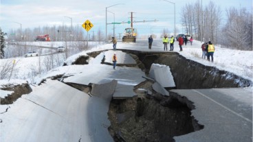
The tsunami, following the earthquake, wiped out entire villages, caused extensive damage to infrastructure and buildings, revealing in the most dramatic way the kind of impact such an event can cause to the nearby coastal communities. But the philosophy of turning disaster into knowledge has led to the understanding of tectonic seabed deformation as well as the development of appropriate warning systems and evacuation routes and procedures through the National Tsunami Hazard Mitigation Program.


Sources: USGS, AlaskaDHSEM
Want to read more like this story?

Massive earthquake hits Alaska: Tsunami warning issued
Jul, 22, 2020 | NewsA massive M 7.8 earthquake that hit off the coast of Alaska, forced authorities to issue a tsunami...

M 7.5 earthquake hit Alaska triggering tsunami warnings
Oct, 19, 2020 | NewsA tsunami warning was issued after a powerful earthquake hit Alaska's southern coast. The M 7.5...

Massive earthquake struck off the coast of New Zealand
Jun, 18, 2020 | NewsA M 7.4 earthquake struck off the coast of New Zealand raising concerns about a potential tsunami....

Simulation: Tsunami In Crete Overwhelms The Mediterranean
Aug, 31, 2015 | NewsPossible strong earthquake in Crete would cause a devastating tsunami that could flood the coast at...

Study suggests that smaller earthquakes generate most strong ground motions
Jan, 04, 2021 | NewsAccording to a new study, smaller earthquakes have caused the strongest shaking incidents in the vi...

Deep landslides triggered by the 1964 Alaska earthquake were not re-activated in the 2018 Anchorage earthquake
Oct, 29, 2019 | NewsAccording to a new study, published in Seismological Research Letters, the deep landslides that wer...

M8.2 earthquake struck off the coast of Alaska
Jul, 28, 2021 | NewsA massive earthquake struck off the coast of Alaska prompting a tsunami alert for a large part of t...

Powerful 7.4-Magnitude Earthquake Strikes Kamchatka Peninsula
Sep, 12, 2025 | NewsA magnitude 7.4 earthquake struck off the east coast of Russia’s Kamchatka Peninsula on September 1...
Alaska struck by a massive M 7.0 earthquake
Dec, 03, 2018 | NewsThe region of Anchorage, Alaska, was struck by a massive M 7.0 on November 30, 2018. The epicente...
On This Day
July 18th 1635
READ MORE
Related Video

Trending
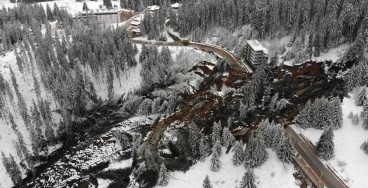
Active landslide threatens long-term connectivity in southern Bulgaria


PLAXIS example: Westergaard's added mass for hydrodynamic pressures

Rock Mass Classification Systems: A Global Review of Use and Dominant Approaches

How does the Leaning Tower of Pisa survive earthquakes
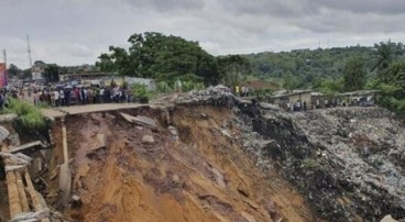
Deadly mining landslide in Central African Republic raises safety concerns