3D Terrain Model Supports the City of Coatesville’s Brownfield Redevelopment Planning Sponsored
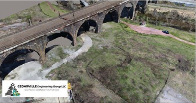
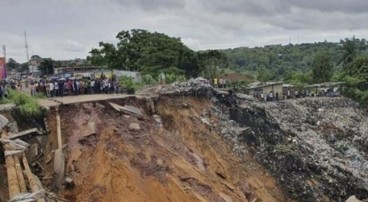
CEDARVILLE Engineering Group (CEDARVILLE) was tasked to provide 3D design and conceptual planning services as part of the city of Coatesville’s “The Flats” brownfield redevelopment, a rugged, 30-acre former steel-mill site located 40 miles west of Philadelphia, Pennsylvania.
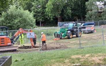
Encompassing foundations and hazardous materials remaining from the old industrial plant, the project required the team to work within a constrained footprint to address surveying restraints related to the area—which also included a floodplain, a creek, and active railroad tracks and highways requiring authorizations to enter. Given the difficult access to the site and level of analysis necessary, CEDARVILLE needed accurate, scalable software to capture a 3D model of existing site conditions.
The project team captured more than 750 aerial photos via a drone in a matter of 20 minutes, and using Bentley’s ContextCapture, incorporated base imagery from four perimeter ground-control points to build a precise reality model. The flexibility of ContextCapture enabled CEDARVILLE to combine old survey data and other photos to create the 3D model, eliminating the need for on-site visits altogether. Moreover, the model enabled accurate quantification of a significant amount of stockpiled clean fill, which is a staple for the redevelopment project.
Using Bentley’s reality modeling application to automatically produce a georeferenced 3D model reduced risk, enhanced decision making, and accelerated buy-in from local municipalities. ContextCapture provided a 3D terrain model that allowed city planners and project engineers to accurately calculate a stockpile hold of about 22,400 cubic yards of fill, which is enough to place two feet of fill over seven acres of the 26 acres within the city boundary. By leveraging reality-capture technology, CEDARVILLE extracted the finest details from the imagery obtained in a fraction of the time that would have been required for traditional surveying. The results demonstrated that the stockpiled material on the site exceeds required zoning provisions.
Read all the details about the projuect here.
Want to read more like this story?

The City of Helsinki leverages Bentley's reality modeling software to create 3D city model
Apr, 04, 2017 | NewsThe City of Helsinki launched a EUR 1 million project to produce a 3D representation of the city to...

Leapfrog Works
Dec, 29, 2022 | Software
How to create 3D dykes using SOIVISION 3D extrusion tools
Sep, 04, 2020 | NewsAdvanced 3D tools such as SVDESIGNER offer a lot of power to the user, but such power is not alw...

North American City Strengthens Riverbank Slope Stability Using PLAXIS
Dec, 01, 2021 | NewsThe following was prepared by a Bentley Expert and first presented by Virtuosity. A city’s engin...

Why Run PLAXIS 3D Analysis?
Jun, 07, 2021 | NewsMost geotechnical engineers use FEA software packages for their geotechnical design. It is especial...

Inspectioneering and Continuous Surveying Made Possible with Reality Modeling
May, 15, 2017 | NewsWith ContextCapture by Bentley, you can produce even the largest and most challenging 3D models of e...

Bentley Systems Advances Reality Modeling to Extend the Scope of Engineering and Surveying Value
Apr, 13, 2017 | NewsBentley Systems, Incorporated, a leading global provider of comprehensive software solutions for adv...

Numerical Modelling: On the Importance of an Appropriate Soil Model
Jul, 22, 2021 | EducationThe following was prepared by Dr. Ronald B.J. Brinkgreve, and first presented by Virtuosity. Numeri...

Digital strategy for a landslide disaster protection project in West Java, Indonesia
Aug, 06, 2019 | NewsA catastrophic landslide affected the road between Bogor and Cianjur two months before the annual...
Form
Looking for more information? Fill in the form and we will contact Bentley for you. Alternatively, you can visit Bentley's website and speak with a Bentley Geotechnical Expert.
On This Day

Related Video

Trending

Unstable Ground: Lessons from the I-80 New Jersey Sinkhole Saga

Seequent announced extended gINT support until Dec 31, 2028
New Release: GeoStudio 2025.2

Artificial Ground Freezing: Applications, Techniques, and Key Considerations
Deadly mining landslide in Central African Republic raises safety concerns