Video of the shrinking Aral Sea: the detrimental effects of an irrigation project

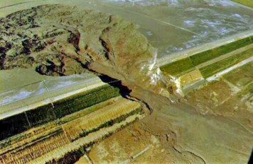
The Aral Sea, once the fourth largest lake in the world is today rapidly shrinking, as a result of the diversion of the two major rivers feeding it, back in the '60s. The effects of the Aral Sea desiccation are widely felt in the local population and the ecosystem, transforming the area in the borders between Kazakhstan and Uzbekistan into a vast toxic desert. Watch the video below with NASA's satellite pictures of the area, showing the water level changes over the years!
The once vibrant Aral Sea in Central Asia, is now almost completely dried up based on the recently released satellite images from NASA's Earth Observatory. The recession of the lake's waters began back in the 1960's as a result of a massive irrigation project undertook by the former Soviet Union. The region's two major rivers, the Amu Darya and Syr Darya, carrying water from snowmelt and precipitation in mountains far from the area, were diverted through irrigation canals to feed cotton and other crops that were created in the desert.
As the lake began to recede, the thriving local fishing industry started to decline and the communities depending on it collapsed. The salinity levels of the water began to rise and progressively became polluted with fertilizer and pesticides. According to a NASA's Earth Observatory release, with the exposure of the lake bed, the winds transferred the contaminated with agricultural chemicals soil in the surrounding croplands, increasing water demands to make the land suitable for agriculture. The local communities also started to suffer from all kinds of respiratory diseases. Another consequence of the lake's desiccation became evident in the local climate, where the absence of such a large body of water to moderate temperatures, made winters colder and summers hotter.
The extent of the lake's recession over the last 14 years has been closely monitored and based on NASA's satellite images the central part of the lake is now completely dry. According to Philip Micklin, a well-known geographer and professor emeritus of Western Michigan University and an Aral Sea expert this is the first time in modern times that this occurs.
Watch the video below with the satellite images showing the progressive recession of the Aral Sea waters!
Sources: CNN, Voice of America, NASA Earth Observatory
Want to read more like this story?

Aral Sea Rebound: Satellite Radar Reveals Slow Uplift of Earth’s Crust
Apr, 08, 2025 | NewsThe drying of the Aral Sea—once the world’s fourth-largest saline lake—has long been a symbol of en...

The Dead Sea 'Dies'
Sep, 09, 2015 | NewsThe Dead Sea dies due to human interventions, with the water level to fall by more than a meter per...

The Lake That Was Born From An Earthquake
Sep, 14, 2015 | NewsDespite the tempting turquoise waters, the story behind this beautiful lake is worrying. The Sarez L...

Earthquakes can aggravate sea water level rise
Jun, 21, 2019 | NewsAccording to a new study published in the Journal of Geophysical Research: Solid Earth, earthquakes...

Mississippi's Oktibbeha County Lake Dam found vulnerable to failure
Jan, 14, 2020 | NewsThe Oktibbeha County Lake Dam located in eastern Mississippi is prone to collapse due to intense pr...

Video: Mine spill in British Columbia to release toxic silt to nearby lake
Sep, 16, 2014 | NewsA tailings pond at the Mount Polley gold and copper mine in central B.C. failed last month and relea...

Study suggests the construction of 2 vast dams in the North Sea to protect Europe from floods
Feb, 20, 2020 | NewsAccording to scientists, as seawater level rises due to climate change, a plan to address flooding...

U.S. coastal areas will be frequently flooded if sea-level rise is not mitigated
Apr, 16, 2020 | NewsAccording to a new study, coastal cities in the United States may experience flooding incidents eve...

California is sinking
Aug, 26, 2015 | NewsCalifornia enters the fifth year of a drought and more and more water is pumped from the aquifer....
On This Day
July 14th 1990
READ MORE
Related Video

Trending

Tiebacks vs. soil nails: Choosing the right earth retention solution
When Dams Fail: The Growing Crisis of Tailings Management

Mexico City’s sinking crisis mapped by next-generation satellite
Landslide in Northern Peru Forces Evacuation of Over 170 Residents
Sinkhole outside home in Huntington Station, on Long Island: 3 fall into

Stop Guessing, Start Designing: Introducing Support Designer in Slide2

Development program prepares new engineers for success