Did Mount Everest shrink after the 2015 Nepal quake?
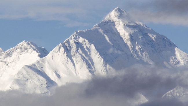
Scientists in India are planning an expedition to measure again the height of Mount Everest, in order to determine whether the world's highest summit has actually become shorter due to the 7.8M April 2015 Nepal earthquake.
After the deadly earthquake of April 2015, the capital city of Kathmandu rose vertically by about 3 ft (1 m), while satellite imagery suggested that Mount Everest shrunk about 1 inch (2.54 centimeters). According to the Press Trust of India (PTI), the Indian government will send an expedition to the mountain in two months from now, in order to measure again its height, which is now officially considered equal to 29,029 feet (8,848 meters). The trip will take a month to complete and will be followed by two weeks of data analysis.
According to John Elliott, geophysicist at the University of Leeds in England, the satellite imagery finding was controversial, as Nepal lies towards the southern limit of the diffuse collisional boundary, where the Indian Plate underthrusts the Eurasian Plate. Earthquakes triggered by such tectonics are known to "shove" earth to the surface and build mountains, instead of shrinking them.
Elliott and his colleagues used satellite imagery to measure displacements in the mountains near Kathmandu, which is about 100 miles (160 km) away from Mount Everest. According to their research, the 2015 Nepal earthquake shrunk the highest mountains, but raised a bit the peaks of the lower ones. If Mount Everest had been closer to the earthquake's epicenter, the shrinking effect would have been more pronounced, but "because Everest is far away, we can't conclusively say it went down; it's within the error of our measurement," Elliott said.
The Indian survey team now plans to measure again the peak, using 2 different techniques, for the shake of accuracy:
- Placement of a GPS device at the top of the mountain to record the distance between the summit and the sea level and
- Triangulation, i.e. they will draw baselines between two points on the Earth's surface at the base of the mountain and then use the angles between those lines and the peak to determine the height.
However, earthquakes are by no means the only force affecting the shape of mountains around the area, as John Elliott states. The Himalayas are growing due to the slow-motion collision between the Indian and Eurasian plates and the subsequent build-up of stress on the faults between those plates.
Since the officially recorded mountain height is based on an Indian survey conducted in 1955 and was last confirmed by the Chinese in 1975, the current height measurement will be a result of not only the change due to the Nepal earthquake, but also the change due to the constant uplift. Considering the area around Kathmandu as indicative, the Himalayan mountains may be growing about 0.25 inches (0.63 cm) per year. This means that the new measurement may eventually show an increase in height, thus not being able to answer the question about possible shrinkage due to the Nepal earthquake.
Source: Live Science
Nearby News
Want to read more like this story?

What controls the height of the world's mountains?
Jun, 12, 2020 | NewsA new study comes to answer an interesting question. What determines the height of the earth's moun...

Photo gallery: Nepal devastated after the 7.9 quake and powerful aftershocks
Apr, 27, 2015 | NewsWith death toll from Saturday's devastating magnitude 7.8 earthquake reaching 3,000, Nepal is strugg...

Seismic Devastation in Tibet: Earthquake Claims Hundred's of Lives and Crumbles Infrastructure
Jan, 07, 2025 | NewsA catastrophic earthquake struck the remote Tingri County in Tibet on January 7, 2025, causing wide...

Massive earthquakes possibly associated with tectonic plates reversal
Apr, 29, 2020 | NewsResearchers have found that there is a possible connection between large seismic shocks and the rev...

Study suggests that smaller earthquakes generate most strong ground motions
Jan, 04, 2021 | NewsAccording to a new study, smaller earthquakes have caused the strongest shaking incidents in the vi...

ARIA Provides New Look of Earth's Surface from Nepal Quake
May, 06, 2015 | NewsIt was only a minute the duration of the earthquake of Nepal, but this minute was enough to deform t...

The complex impact of sea-mountains on earthquake incidents
Mar, 02, 2020 | NewsScientists studied the impact of underwater mountains dragged into subduction zones and the geodyna...

Mexico gets hit again by deadly M7.1 earthquake (video)
Sep, 22, 2017 | NewsThe earthquake struck central Mexico on Tuesday, September 19, killing at least 250 people. The 7...

Videos: landslides triggered during Nepal quake caught live, drone images of destruction and CCTV footage.
Apr, 29, 2015 | NewsTwo new videos reveal the devastation caused by the magnitude 7.8 Nepal earthquake, that severely af...
On This Day

Related Video

Trending

Unstable Ground: Lessons from the I-80 New Jersey Sinkhole Saga

Seequent announced extended gINT support until Dec 31, 2028

New Release: GeoStudio 2025.2


Artificial Ground Freezing: Applications, Techniques, and Key Considerations
Major wastewater tunnel procurement begins in southern Sweden