Helicopters to Scan Wyoming and Colorado for Hidden Minerals


Sources: usgs.gov/news, mininggazette.com
Want to read more like this story?

Recovering Critical Minerals from Waste: New USGS-State Partnerships Underway
Sep, 26, 2025 | NewsThe U.S. Geological Survey (USGS) has awarded nearly $3 million in cooperative agreements to suppor...

Potential $37 billion rare earth mineral deposit found in Wyoming mine
Dec, 18, 2023 | NewsAn old coal mine in rural Wyoming was recently found to contain deposits of rare earth minerals tha...

Bentley Systems Announces Seequent’s Acquisition of Aarhus GeoSoftware
Jul, 07, 2021 | NewsBentley Systems, Incorporated (Nasdaq: BSY), the infrastructure engineering software company, today...

Oasis montaj Fundamentals Remote Training-February-2025
Feb, 18, 2025 | EventThis course is specifically designed for geophysicists, geologists, and other professionals involv...

Mitigating Risk: Disparate Data in the Mining Industry
Aug, 12, 2024 | NewsWith operations often spread across various locations and the involvement of multiple teams, data c...

Leapfrog Works
Dec, 29, 2022 | SoftwareData Management
May, 19, 2020 | Education

How geotechnics can make life simpler, safer and more certain for infrastructure projects
Dec, 10, 2021 | NewsFor any transportation project it’s essential to have a clear view of the subsurface and any proble...

New UK bill aims to unlock geotechnical data and save billions in infrastructure projects
Mar, 04, 2026 | NewsA new legislative proposal in the United Kingdom aims to transform how geotechnical and ground inve...
On This Day
July 16th 1965
READ MORE
Related Video

Trending
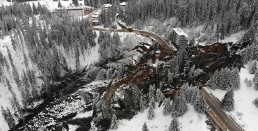
Active landslide threatens long-term connectivity in southern Bulgaria


PLAXIS example: Westergaard's added mass for hydrodynamic pressures

Rock Mass Classification Systems: A Global Review of Use and Dominant Approaches

How does the Leaning Tower of Pisa survive earthquakes
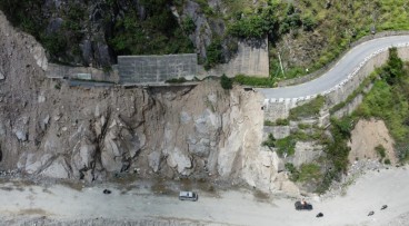
Nepal’s Himalayan settlements face escalating flood and landslide threats