Automating the analysis of 160 ground improvement designs with PLAXIS Sponsored

WSP, using the automation capability of PLAXIS together with Python, found the right ground improvement solution, from more than 160 different design combinations, for the Stephenson Avenue phase 2 exntension in Perth, Western Australia.
The Stephenson Avenue phase 2 extension is a $165 million complex road infrastructure project where site conditions showed varying ground settlement rates were a major roadblock. The extension includes a traffic bridge that crosses the busy Mitchell Freeway (built in the early 1980s) with site ground improvement due for completion in 2024. Data collected by InSAR over a six-year period up to 2020 revealed that although the freeway was built 40 years ago, the site at the proposed road extension is still settling at varying rates of up to a few millimetres a year. “If the approach embankments and bridge ramps were built without ground improvement, the peat would continue to settle significantly,” says Shan Tom Wong, Principal Geotechnical Engineer at WSP Australia.
The WSP team selected the ground improvement method of installing concrete columns through to the competent stratum below the peat layer. Three crucial design variables – peat thickness, embankment height, and concrete column spacing – resulted in a whopping 160 design combinations to be analysed, a huge task to build this many models one by one.
WSP decided to use PLAXIS 2D and 3D modelling software together with Python, which enabled them to (1) design and perform and automate advanced finite element soil and rock deformation analysis and (2) efficiently automate the modelling of all 160 different design combinations.
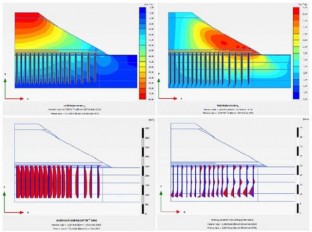
Initially, 160 2D axisymmetric numerical models in PLAXIS were created and the Python wrapper for the PLAXIS API (Application Programming Interface) was used along with the Linear Search or Brute Force Algorithm. Together with forty-year estimated settlements data files for graph plotting enabled the team to automate visualization and inteprete easily the results, as a preliminary decision before more detailed analyses using PLAXIS 3D were conducted, including additional elements such as a retaining wall, to simulate lateral movements of the ground and wall over time. The automation contributed to saving time and cost throughout the project.
The WSP geotechnical team agreed that using PLAXIS together with Python could have many other potential applications, especially in the repetitive design tasks space, to help save time and cost across infrastructure projects.
Source: How WSP automated the analysis of 160 ground improvement designs with PLAXIS
Want to read more like this story?
Optimizing Soil Improvement with PLAXIS: Techniques and Benefits
Nov, 12, 2024 | NewsSoil improvement refers to the process of modifying the physical properties of soil to improve its...

How the Past 30 Years of PLAXIS History Pave the Way for a Promising Future
Oct, 05, 2023 | NewsOver the last 30 years, PLAXIS innovation has driven the geotechnical analysis industry, enabling e...

Bentley releases new PLAXIS versions
Jun, 15, 2020 | NewsBentley is happy to announce the release of new PLAXIS CONNECT version (Edition V20 Update 3), incl...

New release PLAXIS CONNECT Edition V22 Update 1 is out!
May, 19, 2022 | NewsIn this latest minor release for PLAXIS 2D, PLAXIS 3D and Monopile Designer Bentley Systems introdu...

PLAXIS – From Concept to Construction
Mar, 03, 2022 | NewsImporting geometric and stratigraphic data to PLAXIS 3D Any infrastructure project begins with a t...

Bentley Webinar: FE and LE solution for Geotechnical Projects using PLAXIS WorkSuite
May, 11, 2022 | EventPLAXIS 2D/3D WorkSuite is the most comprehensive option of PLAXIS which includes PLAXIS 2D/3D Ultim...

Admiralty Arch Going Digital Project
Oct, 11, 2022 | NewsWSP used Bentley’s PLAXIS geotechnical application and Bentley’s RAM structural engineering applica...

Advanced Techniques with 3D FEA and Satellite Remote Sensing (InSAR) Integration Case Study
Mar, 28, 2023 | NewsThis case study demonstrates how Finite Element Method (FEM) analyses, combined with InSAR remote s...

PLAXIS 2023.2 New release is out!
Sep, 07, 2023 | NewsThis latest release solidifies Seequent's Connected Geotechnical Workflow, reducing the need for du...
Form
Looking for more information? Fill in the form and we will contact Seequent, The Bentley Subsurface Company for you.
On This Day
July 20th 1837
READ MORE
Related Video

Trending
Seven Frequently Asked Questions about Helical Piles

Block caving: A new mining method arises

Categories of isolated foundation footings
Maharashtra's longest road tunnel to be completed soon

Carnian Pluvial Episode: That time when it rained for 1-2 million years
Tailrace tunnel breakthrough advances Australia’s largest renewable project
A Legacy of Leadership, Mentorship & Service: Gary L. Seider P.E.