Bentley Webinar | DAARWIN: Reducing Geotechnical Uncertainty by Connecting PLAXIS Models with IoT Sensors begins on Apr 29th 2024
Bentley Webinar | DAARWIN: Reducing Geotechnical Uncertainty by Connecting PLAXIS Models with IoT Sensors begins on Apr 29th 2024
Create a free account and view content that fits your specific interests in geotechnical engineering Learn More
Plaxis plaxis designer SVDESIGNER Modeling modelling Visualization 3D visualization conceptual modeling stress deformation Slope stability Consolidation groundwater groundwater model calculate volumes depositional surfaces import boreholes piezometer piezometric data 


MORE 
MORE 
MORE 
MORE 
MORE 
PLAXIS Designer Featured
Geotechnical model builder to reduce time for design and analysis using engineered earth structures, construction, topology, borehole, and water data.
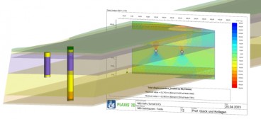
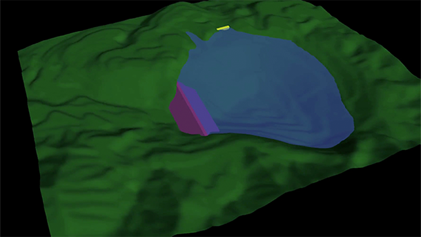
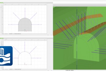
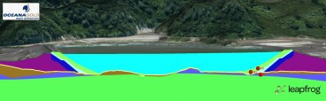
Download DocumentationPLAXIS Designer is a 3D conceptual model builder used to significantly reduce model creation times by visualizing, optimizing, and merging engineered earth structures, staged construction and excavation, topology, borehole, piezometer, and field instrumentation geotechnical data into a well-defined design model for subsequent numerical analysis. Use data from OpenGround and numerous other sources and input formats. Analyze designs with PLAXIS 3D LE, PLAXIS 2D LE, and PLAXIS 2D.
Capabilities
- Calculate material volumes
- Create construction sequences
- Create models quickly
- Create stunning client visuals
- Edit geometry
- Export to numerical modeling modules
- Generate depositional surfaces
- Import boreholes
- Import multiple file types
- Integrate field data
- Intersect surfaces
- Make surface cuts
- Represent complex 3D surfaces
| Category | Data Management , Visualization , Numerical & Constitutive Modeling |
| Licence Type | Commercial |
| Operating Systems | Windows 7, Windows 8, Windows 10 |
| Developer | Bentley Systems |
| Developer Website | https://www.virtuosity.com/software/geotechnical-engineering/plaxis/ |
| Developer Email | [email protected] |
Recommended Software
Jan, 01, 2023
Oasis montaj
Jan, 01, 2023
Res2DInv and Res3DInv

Dec, 29, 2022
Seequent Central
Dec, 29, 2022
Leapfrog Works
Nov, 06, 2020
OpenGround Cloud
News on Software

Mar, 21, 2024
GeoStudio 2024.1 new release is here!
Feb, 24, 2024
PLAXIS 2024.1 New release is out!

Feb, 21, 2024