Numerous landslides reported on Raoul Island (New Zealand) after strong earthquakes
More than 300 landslides struck Raoul Island, New Zealand after strong earthquakes occurred in early March 2021.
A series of earthquakes and aftershocks with the largest being M 8.1 and M 7.4 recently struck off the coast of New Zealand. According to the United States Geological Survey (USGS), the powerful M8.1 shock occurred on a reverse fault in the subduction zone of Tonga-Kermadec which stretches from the North Island to Samoa through Tonga. Its epicentral depth was relatively small (about 22km). At the location of the epicenter, the Pacific Plate is subducting below the Australian Plate at a rate of 6cm annually. The M7.4 earthquake was reportedly a foreshock of the aforementioned seismic shock with its epicenters being very close.
Fortunately, the earthquakes struck far from the main islands of New Zealand, therefore, the ground shaking was attenuated. No infrastructure damage or victims associated with the quakes have been reported.
Authorities in New Zealand issued tsunami alerts and warned people living in coastal areas to evacuate their residences and move to higher ground. The waves that arrived ranged between 15-64cm and did not significantly impact coastal areas, therefore, hours later people were advised to return to their houses. Similar warnings were also raised in Hawaii and in American Samoa with the impact of the earthquake being minor.
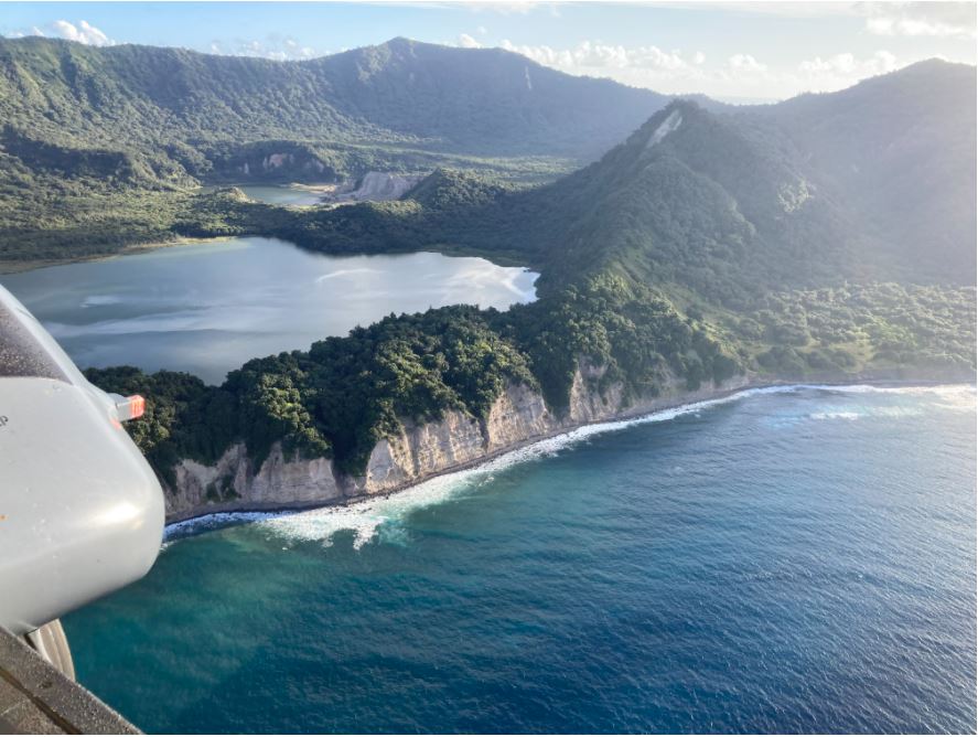
Raoul Island is the largest of the Kermadec Islands and is located northeast of New Zealand's North Island and closest to the epicenter of the earthquakes. According to GeoNet (Geological hazard information for New Zealand), more than 300 ground failures have been documented as a result of the seismic activity.
A research team from GeoNet utilized satellite imagery and photographs retrieved from the Island to identify and map the landslides triggered by the earthquakes. The post-quake model had a resolution of 0.5 meters enabling relatively accurate findings. The team utilized EQIL Tool, a landslide prediction software that provides potential landslide sites given the PGA, the topography and geological factors. They suggest that the Peak Ground Acceleration (PGA) caused by the M8.1 quake in the island ranged between 0.15g and 0.75g.
The ground failures included soil, rock avalanches and rockfalls. The findings show that most of the landslides were relatively small in terms of volume (ranging between 100 and 200 cubic meters). However, 2 large landslides were found on the north-east coast of the island (about 20,000 cubic meters). Most of the mapped slides struck in coastal slopes which are generally steeper and present a higher landslide probability. The team suggests that the results of the prediction model matched the actual observations.
In 2009, a M 8.1 earthquake struck off the coast of Tonga triggering tsunami waves that reached up to 22 meters. At least 375 people died in Tonga, Samoa and American Samoa and the infrastructure damage in the coastal areas was extensive.
Sources: CNN, USGS, GeoNet, BBC
Image Gallery


Want to read more like this story?

Massive earthquake struck off the coast of New Zealand
Jun, 18, 2020 | NewsA M 7.4 earthquake struck off the coast of New Zealand raising concerns about a potential tsunami....

Earthquakes triggered by landslides
Jul, 02, 2020 | NewsIt is widely known that earthquakes can trigger disastrous landslides but, what about the opposite?...

Massive M 7,5 earthquake struck Papua New Guinea
May, 28, 2019 | NewsA powerful M 7.5 earthquake hit the eastern coast of Papua New Guinea on Tuesday, May 14, 2019. Th...

M8.2 earthquake struck off the coast of Alaska
Jul, 28, 2021 | NewsA massive earthquake struck off the coast of Alaska prompting a tsunami alert for a large part of t...

Powerful M 7.0 earthquake struck Greece and Turkey: At least 60 casualties
Oct, 30, 2020 | NewsAt least 60 people have been reported dead and more than 950 injured after a M 7.0 earthquake struc...

Powerful earthquake struck Mexico: At least one fatality
Sep, 08, 2021 | NewsAt least one person died after a M 7.0 earthquake hit southwestern Mexico on September 8, 2021. Th...

Study suggests that smaller earthquakes generate most strong ground motions
Jan, 04, 2021 | NewsAccording to a new study, smaller earthquakes have caused the strongest shaking incidents in the vi...

New study shows 16 earthquakes were triggered by landslide
Jan, 06, 2014 | NewsThe landslide at the Bingham Canyon copper mine that occurred last April, near Salt Lake City in Uta...

Two powerful earthquakes hit China: Reports of 3 people dead
May, 21, 2021 | NewsTwo separate, strong earthquakes that struck in China have resulted in, at least, 3 fatalities. The...
On This Day
July 17th 1839
READ MORE
Related Video

Trending
Brownfield success: Engineering excellence starts below ground


Scripting Comes to RS3: Automate, Customize, and Accelerate Your 3D Modelling

2D and 3D Analysis of Retaining Systems

Mine waste dam failure in Myanmar caught on video
Tailrace tunnel breakthrough advances Australia’s largest renewable project

A Legacy of Leadership, Mentorship & Service: Gary L. Seider P.E.