Combining geological modelling and BIM for infrastructure Sponsored
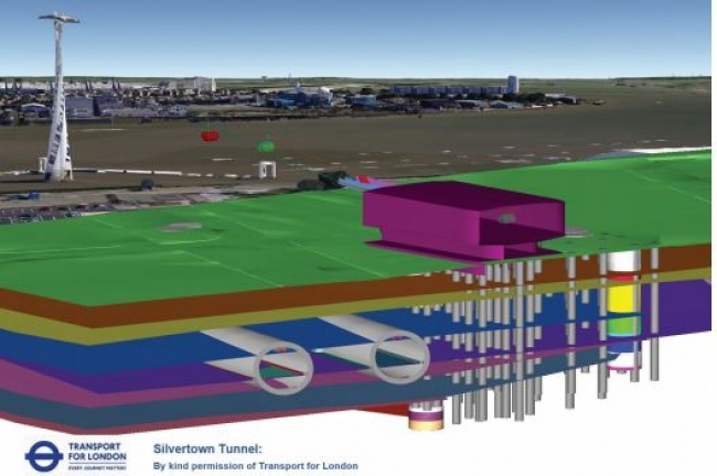
Transport for London (TfL)—the statutory authority responsible for most aspects of Greater London’s transport system—is planning a new road tunnel under the River Thames in East London. The proposed Silvertown Tunnel between Silvertown and North Greenwich will ease the strain on the nearby Blackwall Tunnel and other existing crossings. Engineering and design consultancy Atkins developed the project’s reference design.
The south portal of the tunnel route is the site of a demolished gas works. The soil in that area is contaminated and there are still remnants of the underground foundations of the plant. On the south and north banks, the proposed tunnel location comes close to the pylon foundations of the Emirates Air Line cable car. Additionally, the north bank tunnel portal is in the area of the now-filled western entrance to the Royal Victoria Dock and some demolished warehouses. Like the gas works on the south bank, there are still underground remnants of these features. “The tunnel on both sides of the river will need to thread through heavily industrialized areas of London, with a myriad of existing soil types, roads, foundations, and other subsurface structures, as well as subsurface remnants of demolished structures,” explains Simon Miles, a principal geotechnical engineer with Atkins. “To reduce the overall project cost and risk, we needed ways to better see and understand subsurface soil conditions in the context of existing built conditions, and calculate earthwork quantities and areas that will be impacted by construction.” The increased costs of treating contaminated materials makes accurate volume calculations vital for assessing cost implications.
The solution
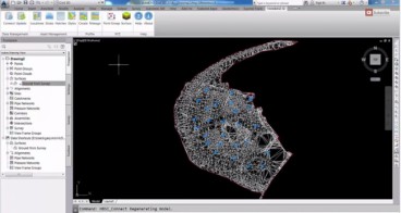
For many years, Atkins has been using AutoCAD® Civil 3D® from Autodesk for civil engineering design and documentation, and HoleBASE SI from Keynetix for geotechnical knowledge management. For its preliminary design of the Silvertown Tunnel, the firm used the HoleBASE SI Extension for AutoCAD Civil 3D to quickly visualize geotechnical data in the model-based, multidisciplinary Civil 3D environmen.
“With the HoleBASE SI Extension for Civil 3D, we could quickly combine, organize, and manage geology data, and then see that data in the context of existing and proposed above and below-ground structures,” says Jerome Chamfray, an Atkins BIM Manager. “This helped us visually understand and evaluate the design alignment, pinpoint potential construction obstructions, and determine what new site investigations were needed.” Moreover, Atkins used Civil 3D to automatically generate earthworks quantities for project costing and risk assessment.
Read the rest of the Success Story here.
Source: http://www.keynetix.com/
Want to read more like this story?
Watch Keynetix's video and learn how to display Boring Data in AutoCAD Civil 3D!
Mar, 04, 2015 | NewsIn this video you will learn the best practice for importing and displaying borehole data into the G...

Bentley Webinar | Modeling With Tunnel Designer in PLAXIS 2D & 3D
Mar, 21, 2023 | EventTunnels are created to make it easier to navigate through challenging topographical and geological...

3 major East Coast tunnel, the Hudson Tunnel, the Howard Street Tunnel and the Chesapeake Bay Bridge Tunnel, projects move forward
Jan, 11, 2022 | NewsThree major tunnel projects that connect key transportation arteries on the East Coast are advancin...

Keynetix develops Geotechnical Module for AutoCAD Civil 3D 2015
Aug, 07, 2014 | NewsKeynetix has recently developed a new Geotechnical module, which is incorporated into AutoCAD Civil...

Controversy over the New Thames tunnel in London
Sep, 12, 2021 | NewsSilvertown tunnel, a project that will potentially be the first in 3 decades to connect the two sid...

Rocscience | Geotechnical Software for Tunnelling
Jun, 24, 2022 | NewsTunnelling is a specialized civil engineering discipline for designing and constructing underground...

8 new U.S. tunnels under way: fascinating and challenging
Jan, 10, 2014 | NewsWhether you live in the U.S. or not you will find the following tunnels that are currently being bui...

Final design of HS2 Chiltern Tunnel’s North Portal revealed
Mar, 21, 2023 | NewsHigh Speed 2 (HS2) revealed the final designs of Chiltern Tunnel’s North Portal on Tuesday, March 2...

Video: Digging smart tunnels under London - an underground high-tech lab!
Jun, 19, 2014 | NewsCrossrail - the largest infrastructure project currently under construction in Europe - wi...
Form
Looking for more information? Fill in the form and we will contact Bentley for you. Alternatively, you can visit Bentley's website and speak with a Bentley Geotechnical Expert.
On This Day
April 18th 1906
READ MORE
Trending

Categories of isolated foundation footings

Best Alternatives for Fossil Fuels

Functional requirements of foundation structures

Block caving: A new mining method arises

Potential $37 billion rare earth mineral deposit found in Wyoming mine

Strongest earthquake in 25 years rattles Taiwan