Sydney Metro Rail Geotechnical Drilling Unearths Secrets
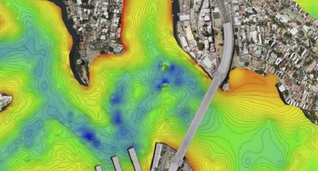
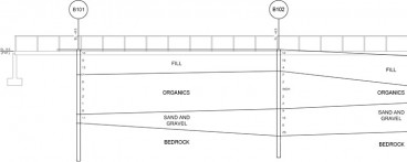
The geotechnical investigations for the Sydney Rail Project has sampled and analyzed previously unearthed geology aspects of the Sydney harbor. Since April, 2015, barges on the harbor have been drilled borings to 80 meters below the water's depth in an effort to map the contours of the harbor's previously poorly understood rock bed to find a path for the rail line.
Previous geotechnical explorations have not explored as deep as this project. Depth of competent rock is much deeper than expected.
Information for this article is taken from Sydney Morning Herold reporting. Further sampling pictures and videos are available.
Want to read more like this story?
Other Geotechnical
Jun, 04, 2019 | Education

Geotechnical works in progress for Doha metro
Mar, 02, 2015 | NewsGeotechnical investigations are on their way for the metro line in Doha. The $1.37 million project i...

Dams storage in Syndey drops below 50% for the first time in 15 years
Aug, 22, 2019 | NewsFor the first time since 2004, the levels of Sydney's dams have dropped below 50%. In May 2004, the...

What is Geotechnical Engineering?
Jun, 25, 2020 | EducationGeotechnical Engineering has been - throughout the years - an often overlooked but nonetheless inte...

Storm damage in Dawlish rail, U.K. cuts off regions and calls for inland lines.
Mar, 11, 2014 | NewsThe recent high winds, rain and high tides in the area of Dawlish, U.K. left a 30 metre section of t...

Possible second tunnel in Sydney harbour
Dec, 01, 2014 | NewsA second harbour tunnel is within the State Infrastructure Strategy's development plans in Sydney. T...
Geotechnical Earthquake Engineering
Apr, 21, 2020 | Education
Deep Foundation “Feedback”: Valuable Early Data From The Jobsite
Dec, 20, 2021 | NewsLearn how Geotechnical Engineers use valuable jobsite data to validate their recommendations for de...

Badgerys Creek airport site is taking shape
May, 18, 2015 | NewsIt is a fact that the airport at Badgerys Creek is on its way, since the geotechnical works have beg...
On This Day
April 19th 1916
READ MORE
Trending


What controls the height of the world's mountains?


How Do Dams Trigger Earthquakes?

Chesapeake Bay Bridge-Tunnel: An ‘engineering wonder’ of the modern world


